LOWER CHIQUITO

Amenities Weather Recreation


CAMPING CALIFORNIA

Lower Chiquito


April 23, 2024

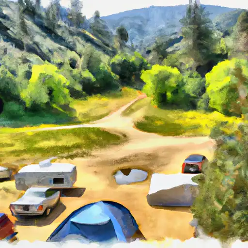
Lower Chiquito Camping Area is a beautiful campsite located in the Sierra National Forest in California, offering breathtaking views of the surrounding mountains and forests. The nearby points of interest include the stunning Bass Lake, which is perfect for swimming, boating, and fishing. The area also offers hiking trails and scenic drives. The campground has basic amenities like vault toilets, fire rings, and picnic tables. The camping area is on a first-come-first-serve basis with 25 campsites available. The best time to visit is from May to October when the temperatures range from 70 to 90 degrees Fahrenheit. It is important to note that the campground is located at an elevation of 4,400 feet, so visitors should be prepared for cooler evenings. Overall, Lower Chiquito Camping Area is an ideal getaway for those looking for a peaceful and serene natural setting.


Weather Outlook


16 Day Long Term Forecast

Seasonal Comparison


Historical Data


Fishing Destinations


Lillian Lake

Apache Trout Brook Trout Golden Trout Rainbow Trout

Grizzly Lake

Apache Trout Brown Trout Rainbow Trout

Lewis Creek

Apache Trout Rainbow Trout

Fern Lake

Apache Trout Bluefin Tuna Bluegill Kelp Bass

Manzanita Lake

Apache Trout Black Sea Bass Brown Trout

Kings River, below Pine Flat Reservoir

Apache Trout Kelp Bass

Rush Creek

Apache Trout Brown Trout

East Fork Granite Creek

Apache Trout Brook Trout

Junction Lake

Apache Trout Rainbow Trout

Dinkey Meadow Creek

Apache Trout Brook Trout

Shaver Lake

Apache Trout Atlantic Salmon Brown Trout Kelp Bass Rainbow Trout Smallmouth Bass

California Creek

Apache Trout Brown Trout Kelp Bass Smallmouth Bass

Rancheria Creek

Apache Trout Atlantic Salmon Blue Catfish Brown Trout Kelp Bass

Alpine Lake

Apache Trout Blue Catfish Bluegill Brown Trout Kelp Bass Rainbow Trout

Beryl Lake

Apache Trout Cutthroat Trout

Silver Lake (June Lake)

Apache Trout Brook Trout

Evelyn Lake

Apache Trout Brook Trout Brown Trout Rainbow Trout

Isberg Lakes

Apache Trout Brown Trout Rainbow Trout

Jackass Lakes

Almaco Jack Apache Trout Brook Trout

Ediza Lake

Apache Trout Brown Trout

Millerton Lake

Apache Trout Black Crappie Blue Catfish Kelp Bass Rainbow Trout Spotted Bass

Grant Lake

Apache Trout Atlantic Salmon Brown Trout Rainbow Trout

Fish Creek

Apache Trout Brown Trout Rainbow Trout

Vandeburg Lake

Blue Catfish Bluegill Kelp Bass

Pine Flat Lake

Apache Trout Black Crappie Blue Catfish Bluegill Kelp Bass Largemouth Bass Rainbow Trout

Finger Lake

Apache Trout Atlantic Salmon Kelp Bass


Rafting & Kayaking

HEADWATERS IN SEC 7, T11N, R18E TO BLAIR BRIDGE
Lake Tahoe Watershed, California
CENTERVILLE FLAT TO HANGMAN'S BRIDGE
Upper Carson Watershed, California
CONFLUENCE WITH VAN HORN CREEK TO COSUMNES MINE ROAD
Upper Cosumnes Watershed, California
HELL HOLE DAM TO ELLICOTTS BRIDGE
North Fork American Watershed, California
HEADWATERS TO SOUTH OF UPPER TRUCKEE ROAD (SEC LINE BETWEEN 17/20 INTERCEPTS RIVER AND UNNAMED TRIBUTARY)
Lake Tahoe Watershed, California
STATE HIGHWAY 50 TO 1/4 MILE NORTH OF STATE HIGHWAY 50
South Fork American Watershed, California
HEADWATERS IN SEC 2, T9N, R18E TO CONFLUENCE WITH MOKELUMNE RIVER
Upper Mokelumne Watershed, California
1/4 MILE NORTH OF STATE HIGHWAY 50 TO AVALANCHE LAKE
South Fork American Watershed, California
HIGHWAY 4 TO SALT SPRINGS RESERVOIR
Upper Mokelumne Watershed, California
HEADWATERS IN SEC 15,T10N, R17E TO CONFLUENCE WITH SILVER FORK OF AMERICAN RIVER
South Fork American Watershed, California

Log Your Visit

When was your last visit to Lower Chiquito?

Add a Photo

How was it? How were conditions?

Rate the camping


Submit

Leave A Review

Lower Chiquito

Submit

Upload an Image

Lower Chiquito

Favorite Limit Reached