NOE CREEK

Amenities Weather Recreation


CAMPING IDAHO

Noe Creek


April 18, 2024

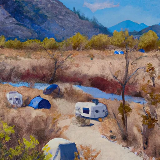
Noe Creek camping area is a beautiful campground located in the state of Idaho. Situated in a scenic natural setting, campers can enjoy a range of amenities during their stay. The campground offers spacious campsites with picnic tables and fire rings, providing a comfortable and convenient camping experience. Additionally, there are clean restrooms and potable water available for campers' use.

Reservations are not accepted at Noe Creek camping area, making it a first-come, first-served campground. It is recommended to arrive early, especially during peak periods, to secure a campsite. The best time to visit this campground is during the summer months, from May to September, when the weather is generally mild and pleasant. However, it's important to note that the campground may be busier during weekends and holidays.

While camping at Noe Creek, visitors can explore the surrounding area's scenic beauty and engage in various outdoor activities, including hiking, fishing, and wildlife viewing. The pristine Noe Creek and its nearby trails provide excellent opportunities for nature enthusiasts. It is advised to be cautious of wildlife encounters and ensure proper food storage to prevent attracting animals. Overall, Noe Creek camping area offers a serene and picturesque getaway for campers seeking a tranquil outdoor experience in Idaho.


Weather Outlook


16 Day Long Term Forecast

Seasonal Comparison


Historical Data


Fishing Destinations


Fenn Pond

Apache Trout Black Sea Bass Brook Trout Brown Trout Cutthroat Trout Rainbow Trout

Bonanza Lakes

Apache Trout Cutthroat Trout


Rafting & Kayaking

10 MILES FROM TUB GULCH TO QUARTZ CREEK TO 10 MILES FROM TUB GULCH TO QUARTZ CREEK
Upper Kootenai Watershed, Montana
FROM THE HEADWATERS OF THE WEST FORK OF QUARTZ CREEK DOWNSTREAM FOR THREE MILES TO THE BOUNDARY OF THE FLAGSTAFF MOUNTAIN INVENTORIED ROADLESS AREA #690 TO
Upper Kootenai Watershed, Montana
CABINET MTNS WILDERNESS BOUNDARY, SEC. 3, T27N, R32W TO BULL RIVER, SEC. 12, T27N, R33W
Lower Clark Fork Watershed, Idaho
EAST FORK BULL RIVER, HEADWATERS, SEC. 13, T27N, R32W TO CABINET MOUNTAINS WILDERNESS BOUNDARY, SEC. 3, T27N, R32W
Lower Clark Fork Watershed, Idaho
FROM THE BOUNDARY OF THE FLAGSTAFF MOUNTAIN INVENTORIED ROADLESS AREA #690 DOWNSTREAM FOR THREE MILES TO THE CONFLUENCE OF MAIN QUARTZ CREEK TO
Upper Kootenai Watershed, Montana
NORTH FORK BULL RIVER, SEC. 32, T29N, R32W TO PROPOSED CABINET MTNS WILDERNESS BOUNDARY, SEC. 1, T28N, R32W
Lower Clark Fork Watershed, Montana
9 MILES FROM QUARTZ CREEK TO SURPRISE GULCH,TWO MILES BELOW KOOTENAI FALLS TO 9 MILES FROM QUARTZ CREEK TO SURPRISE GULCH,TWO MILES BELOW KOOTENAI FALLS
Upper Kootenai Watershed, Montana
JUNCTION OF THE FISHER RIVER (THREE MILES SOWNSTREAM OF LIBBY DAM) TO TUB GULCH, APPROXIMATELY FOUR MILES UPSTREAM FROM THE TOWN OF LIBBY, MONTANA
Upper Kootenai Watershed, Montana
10 MILES FROM SURPRISE GULCH TO A MILE BELOW KOOTENAI VISTA ESTATES TO 10 MILES FROM SURPRISE GULCH TO A MILE BELOW KOOTENAI VISTA ESTATES
Upper Kootenai Watershed, Montana
MIDDLE FORK BULL RIVER, SEC. 9, T28N, R33W TO PROPOSED ADDITION TO CABINET MTNS WILDERNESS, SEC. 12, T28N, R33W
Lower Clark Fork Watershed, Idaho

Log Your Visit

When was your last visit to Noe Creek?

Add a Photo

How was it? How were conditions?

Rate the camping


Submit

Leave A Review

Noe Creek

Submit

Upload an Image

Noe Creek

Favorite Limit Reached