Make an Announcement

Communicate warnings, disperse advice, and share.


BOUNDARY CREEK TO CACHE BAR

Whitewater River Run


Idaho 
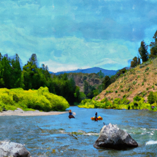
Salmon River, Middle Fork

Boundary Creek To Cache Bar

Class III TO IV+

STREAMFLOW: 11,000 CFS

Runnable
85°, Sunny Then Showers Likely

The Boundary Creek to Cache Bar river run in Idaho offers class III to IV rapids with a few class V drops, making it a challenging and exciting run for experienced paddlers. Obstacles include tight turns, steep drops, and rocky sections, but the scenery and wildlife make it a rewarding experience. The best time to float this section is typically in May or June with a recommended flow of at least 1,000 cfs. Overall, this run is not recommended for beginners, but experienced paddlers will love the challenge and beauty it offers.

Weather today, Showers likely and possibly a thunderstorm after noon. Sunny during the morning, then mostly cloudy during the afternoon, with a high near 85. Light and variable wind becoming west southwest 5 to 7 mph in the afternoon. Chance of precipitation is 60%.

Status Runnable
Class Level III to IV+
Elevation 3,017 ft
Run Length 100.0 Mi
Streamflow Discharge 11000 cfs
Gauge Height 38.5 ft
Reporting Streamgage Middle Fork Salmon River At Mouth Nr Shoup Id
USGS 13310199

Nearby Snowpack and Streamflow Levels

Gauge Streamflow Stage
Sf Boise River At Neal Bridge Nr Arrowrock Dam Id
USGS 13192200
360 cfs 7.2 ft
Lake Fork Payette River Ab Jumbo Cr Nr Mccall Id
USGS 13240000
592 cfs 6.5 ft
Efsf Salmon R Abv Sugar Crk Nr Stibnite
USGS 13311250
175 cfs 11.9 ft
Valley Creek At Stanley Id
USGS 13295000
658 cfs 2.2 ft
Mores Creek Ab Robie Creek Nr Arrowrock Dam Id
USGS 13200000
552 cfs 3.8 ft
Sf Payette River At Lowman Id
USGS 13235000
3,090 cfs 5.6 ft
Ef Of Sf Salmon River At Stibnite Id
USGS 13311000
139 cfs 5.9 ft
Boise River Nr Twin Springs Id
USGS 13185000
4,760 cfs 9.9 ft
Sugar Creek Nr Stibnite
USGS 13311450
92 cfs 7.6 ft
Middle Fork Payette River Nr Crouch Id
USGS 13237920
1,230 cfs 8.3 ft
Snotel Site Snowpack 24hr Change
Vienna Mine
SNOTEL 845
18" -3"
Trinity Mtn.
SNOTEL 830
38" -3"
Deadwood Summit
SNOTEL 439
25" -3"
Big Creek Summit
SNOTEL 338
1" -3"

Popular Destinations

Campground Campsites Reservations Toilets Showers Elevation
Fir Creek 5 6,343 ft
Helende 10 4,189 ft
Bonneville 22 4,673 ft
Golden Gate 9 4,817 ft
Dagger Falls 14 5,758 ft
Bear Valley 10 6,405 ft
Josephus Lake 14 7,039 ft
Thatcher C/G 5 6,605 ft
Bench Creek C/G 5 6,946 ft
Ice Hole 10 5,031 ft
Bull Trout Lake 30 6,985 ft
Grandjean 31 5,182 ft
Lola Creek C/G 27 6,469 ft
Boundary Creek /Complex 35 5,700 ft
Ski Area Snowpack Air Temperature 5 Day Forecast
Mount Pandora 0" 75° 0"
River Run Streamflow Length Class
Boundary Creek to Cache Bar 11000.0cfs 100.0 Mi III to IV+
Headwaters (Gold Creek to Stanley) 8330.0cfs 10.2 Mi III- to III+
Boundary Creek to Cache Bar 11000.0cfs 100.0 Mi III to IV+
Secesh to Main (The Canyon) 1720.0cfs 52.0 Mi III to V
Boundary Creek to Cache Bar 11000.0cfs 100.0 Mi III to IV+
Sunbeam Run (Stanley to Sunbeam Dam) 8330.0cfs 13.0 Mi III- to III+

Log Your Visit

When was your last visit to Boundary Creek to Cache Bar?

Add a Photo

How was it? How were conditions?

Rate the paddle


Submit

Leave A Review

Boundary Creek To Cache Bar

Submit

Upload an Image

Boundary Creek To Cache Bar
Login

Need an Account?

Forgot Your Password?

Delete User Account

Welcome to Snoflo


Continue with a free account

Already Have an Account?


Snoflo Premium

Your first week's free. Cancel anytime

Have a Promo Code?


Already Have an Account?

Signup for Basic Access


Welcome to Snoflo


Continue with a free account

Add Snoflo Premium


Already Have an Account?


Please Verify Your Account

Favorite Limit Reached
Signup for a Free Account

Already Have an Account?