Picacho Peak State Park Campground
Community Reviews
Been here? Share the conditions.
Reviews, ratings & photos are added in the free Snoflo iOS app — rate a spot, tag the conditions, and your visit is verified by location. Add or manage your reviews from the app.
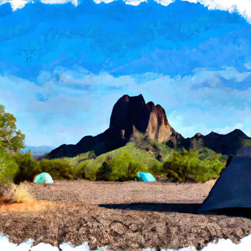
Picacho Peak State Park
Reservations are highly recommended for camping at Picacho Peak State Park. They can be made online or by phone up to 6 months in advance. The park accepts reservations for both tent and RV camping, making it convenient for all types of campers. It is advisable to make reservations well in advance, especially during peak seasons, to secure a spot.
The best time to visit Picacho Peak State Park is during the cooler months, from October to April, as the summer temperatures in Arizona can be extremely hot. The park offers various recreational activities, such as hiking, picnicking, and wildlife observation. A notable trail in the park is the Hunter Trail, which leads hikers to the summit of Picacho Peak, providing a challenging and rewarding experience. However, caution should be exercised on this trail, as it involves steep sections and cables for assistance. Additionally, visitors should be aware of potential encounters with desert wildlife, including rattlesnakes, and take appropriate precautions.
Overall, Picacho Peak State Park offers a well-equipped campground with beautiful surroundings and various recreational opportunities. By following safety guidelines and making reservations in advance, campers can enjoy a memorable experience at this remarkable Arizona camping destination.
What's on-site at Picacho Peak State Park
Key facilities Snoflo tracks for this campground. Confirm with the operator before booking -- amenities can change seasonally.
Plan your trip down to the hour
Same weather feed Snoflo's iOS app uses -- updated continuously from NOAA / yr.no.
Next 5 days, hour by hour
Temperature line with weather symbols on top, snow + rain accumulation as columns, humidity as a dotted line.
5-day forecast table
Every 3 hours, broken out across temperature, snow, rain, humidity, and wind. Each cell is colour-coded relative to the column min/max so trends jump out at a glance.
| Time | Condition | Temp (°F) | Snow (in) | Rain (in) | Humidity (%) | Wind (mps) | Wind dir |
|---|---|---|---|---|---|---|---|
| Loading detailed forecast… | |||||||
15-day temperature & precipitation
Daily temperatures, snow, and rain projected over the next two weeks. Hover any point for the full breakdown.
Other campgrounds in the area
Snoflo-tracked campsites within driving distance of Picacho Peak State Park, with reservations status.
| Campground | Reservations | Toilets | View |
|---|---|---|---|
| Raven Group Tent Area | ✗ | ✗ | → |
| Dispersed Camping | ✗ | ✗ | → |
| Silverbell Group Site | ✗ | ✗ | → |
| A Bar A Rv Park | ✗ | ✗ | → |
Nearby streamflow
USGS streamgauges within reach of Picacho Peak State Park -- pulled live from the National Water Information System.
| Streamgauge | Discharge | View |
|---|---|---|
| Santa Cruz River At Trico Road | 29 cfs | → |
| Santa Cruz River At Cortaro | 52 cfs | → |
| Canada Del Oro Blw Ina Road | · | → |
| Florence-Casa Grande Canal | 0 cfs | → |
| Rillito Creek At La Cholla Blvd Near Tucson | · | → |
| Santa Cruz River At Tucson | 254 cfs | → |
Plan a longer trip
The closest parks, lakes, boat launches, and paddle runs so a camping night can grow into a full weekend.
Parks
- Picacho Peak State Park
- Moore Road District Park
- Marana Park
- Cap Tangerine Road Park
- Rillito Vista Neighborhood Park
- Tortolita Mountain Park
Fishing spots
Points of interest
- Picacho Peak State Park Visitor Center
- Rooster Cogburn’S Ostrich Ranch
- Kvng-Fm (Eloy)
- Bell Ah1 Cobra Michelle
- Downtown Marana Sign/Cowboy Statue
- Kkmr-Fm (Arizona City)
Paddle runs
- Pusch Ridge Wilderness Boundary To Confluence With Cañada Del Oro
- 1/4 Mile South Of Forest Road 736 To Coronado National Forest Boundary
- Headwaters To 1/4 Mile South Of Forest Road 736
- Headwaters To Pusch Ridge Wilderness Boundary
- Kelvin Run
- Marshall Gulch Recreation Area To Wilderness Boundary
Camping essentials & Leave No Trace
- Pack it in, pack it out
- Take all trash, food scraps, and gear back with you to keep campsites clean and protect wildlife.
- Respect wildlife
- Observe animals from a distance, store food securely, and never feed wildlife to maintain natural behavior and safety.
- Know before you go
- Check weather, fire restrictions, trail conditions, and permit requirements to ensure a safe and well-planned trip.
- Minimize campfire impact
- Use established fire rings, keep fires small, fully extinguish them, or opt for a camp stove when fires are restricted.
- Leave what you find
- Preserve natural and cultural features by avoiding removal of plants, rocks, artifacts, or other elements of the environment.
Set push alerts in the Snoflo app
Save Picacho Peak State Park as a favorite, set a custom threshold (precipitation, snowpack, freezing temperatures), and the iOS app will push the moment conditions cross.
About Picacho Peak State Park
Can I make reservations at Picacho Peak State Park?
Yes -- this campground accepts reservations. Snoflo recommends booking early for peak season; check the operator (Recreation.gov / state park system / private operator) for the booking window and cancellation policy.
How fresh is the weather data on this page?
The hourly forecast updates throughout the day from the NOAA / yr.no public feeds. Streamflow data is pulled live from USGS streamgauges and snowpack from the NRCS SNOTEL network.
What's the best time of year to visit?
Use the 15-day temperature & precipitation outlook on this page to plan -- pick a window with comfortable temperatures and low precipitation. For longer trips, the 5-day hourly meteogram shows snow + rain accumulation hour-by-hour.
How do I get to Picacho Peak State Park?
Tap Directions in the hero above to open driving directions in Google Maps, or Open in map to center the Snoflo interactive map on the campground.
Can I get alerts when conditions change?
Yes -- alerts are managed through the Snoflo iOS app. Favorite this campground, set a threshold (temperature, snowpack, precipitation), and you'll get a push the moment it crosses.
Other campgrounds near here
Snoflo-tracked campgrounds within driving distance of Picacho Peak State Park.