Water Wheel Campground
Community Reviews
Been here? Share the conditions.
Reviews, ratings & photos are added in the free Snoflo iOS app — rate a spot, tag the conditions, and your visit is verified by location. Add or manage your reviews from the app.
Water Wheel
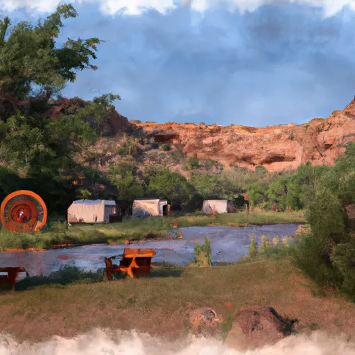
The campground itself offers a range of amenities for visitors, including picnic tables, fire pits, and restrooms with running water. The area also features a nearby store where campers can purchase supplies and groceries. The campground is available on a first-come-first-serve basis, with a total of 24 campsites available.
An interesting fact about the area is that it is known for its rich mining history, dating back to the late 1800s. The nearby town of Payson was once a bustling mining community, and remnants of the past can still be seen in the surrounding landscape.
The best time of year to visit the Water Wheel Camping Area is during the spring and fall months, when temperatures are mild and comfortable. Average temperatures during this time range from the mid-60s to mid-70s Fahrenheit. Visitors should be prepared for occasional rain showers during the summer months.
What's on-site at Water Wheel
Key facilities Snoflo tracks for this campground. Confirm with the operator before booking -- amenities can change seasonally.
Plan your trip down to the hour
Same weather feed Snoflo's iOS app uses -- updated continuously from NOAA / yr.no.
Next 5 days, hour by hour
Temperature line with weather symbols on top, snow + rain accumulation as columns, humidity as a dotted line.
5-day forecast table
Every 3 hours, broken out across temperature, snow, rain, humidity, and wind. Each cell is colour-coded relative to the column min/max so trends jump out at a glance.
| Time | Condition | Temp (°F) | Snow (in) | Rain (in) | Humidity (%) | Wind (mps) | Wind dir |
|---|---|---|---|---|---|---|---|
| Loading detailed forecast… | |||||||
15-day temperature & precipitation
Daily temperatures, snow, and rain projected over the next two weeks. Hover any point for the full breakdown.
Other campgrounds in the area
Snoflo-tracked campsites within driving distance of Water Wheel, with reservations status.
| Campground | Reservations | Toilets | View |
|---|---|---|---|
| Isaac Creek | ✓ | ✓ | → |
| Damsite West Bank | ✗ | ✓ | → |
| Haines Island | ✗ | ✓ | → |
| Bells Landing | ✗ | ✓ | → |
| Old Lock 1 - Coffeeville Lake | ✓ | ✓ | → |
| Saint Stephens Park Campsite 2 | ✗ | ✗ | → |
Nearby streamflow
USGS streamgauges within reach of Water Wheel -- pulled live from the National Water Information System.
| Streamgauge | Discharge | View |
|---|---|---|
| Cienga Creek Near Sonoita | 0 cfs | → |
| Pantano Wash Near Vail | 0 cfs | → |
| Upper Babocomari River Near Huachuca City | · | → |
| Rincon Creek Near Tucson | · | → |
| Babocomari River Near Tombstone | 0 cfs | → |
| San Pedro River Near Tombstone | 89 cfs | → |
Nearby snow depths
NRCS SNOTEL stations within reach of Water Wheel -- relevant when planning a shoulder-season or alpine trip.
| SNOTEL station | Snowpack | 24h Snowfall | View |
|---|---|---|---|
| Nohrsc Baker Butte Smt | 0.0 in | 0.0 in | → |
| Baker Butte Smt | 0.0 in | 0.0 in | → |
| Baker Butte | 1.0 in | 0.0 in | → |
| Promontory | 0.0 in | 0.0 in | → |
| Nohrsc Happy Jack | 0.0 in | 0.0 in | → |
| Happy Jack | 0.0 in | 0.0 in | → |
Plan a longer trip
The closest parks, lakes, boat launches, and paddle runs so a camping night can grow into a full weekend.
Camping essentials & Leave No Trace
- Pack it in, pack it out
- Take all trash, food scraps, and gear back with you to keep campsites clean and protect wildlife.
- Respect wildlife
- Observe animals from a distance, store food securely, and never feed wildlife to maintain natural behavior and safety.
- Know before you go
- Check weather, fire restrictions, trail conditions, and permit requirements to ensure a safe and well-planned trip.
- Minimize campfire impact
- Use established fire rings, keep fires small, fully extinguish them, or opt for a camp stove when fires are restricted.
- Leave what you find
- Preserve natural and cultural features by avoiding removal of plants, rocks, artifacts, or other elements of the environment.
Set push alerts in the Snoflo app
Save Water Wheel as a favorite, set a custom threshold (precipitation, snowpack, freezing temperatures), and the iOS app will push the moment conditions cross.
About Water Wheel
Can I make reservations at Water Wheel?
This campground does not appear to accept reservations -- it's typically first-come, first-served. Arrive early on summer weekends.
How fresh is the weather data on this page?
The hourly forecast updates throughout the day from the NOAA / yr.no public feeds. Streamflow data is pulled live from USGS streamgauges and snowpack from the NRCS SNOTEL network.
What's the best time of year to visit?
Use the 15-day temperature & precipitation outlook on this page to plan -- pick a window with comfortable temperatures and low precipitation. For longer trips, the 5-day hourly meteogram shows snow + rain accumulation hour-by-hour.
How do I get to Water Wheel?
Tap Directions in the hero above to open driving directions in Google Maps, or Open in map to center the Snoflo interactive map on the campground.
Can I get alerts when conditions change?
Yes -- alerts are managed through the Snoflo iOS app. Favorite this campground, set a threshold (temperature, snowpack, precipitation), and you'll get a push the moment it crosses.
Other campgrounds near here
Snoflo-tracked campgrounds within driving distance of Water Wheel.