Upper Blue Lake Campground
Community Reviews
Been here? Share the conditions.
Reviews, ratings & photos are added in the free Snoflo iOS app — rate a spot, tag the conditions, and your visit is verified by location. Add or manage your reviews from the app.
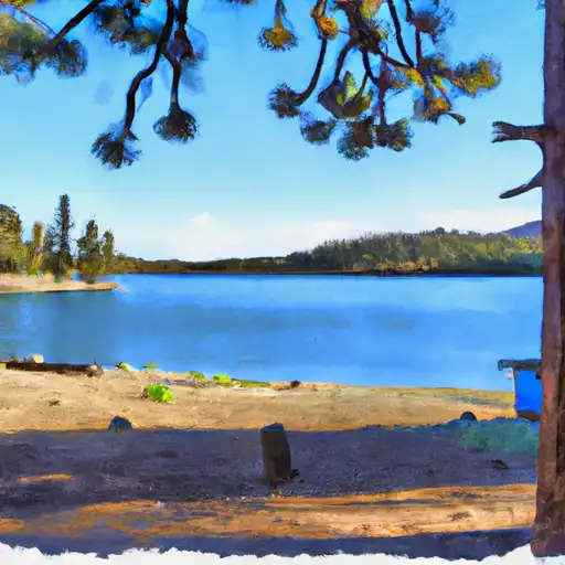
Upper Blue Lake
The campground amenities include picnic tables, fire rings, restrooms, and drinking water. It is a first-come, first-serve campground with 20 individual campsites and 2 group sites. An interesting fact about the area is that it is home to a variety of wildlife, including black bears, mountain lions, and bald eagles.
The best time of year to visit Upper Blue Lake is from June through September, with average temperatures ranging from 65 to 85 degrees Fahrenheit. Visitors can enjoy fishing, boating, hiking, and scenic drives in the area. Overall, Upper Blue Lake camping area is a great destination for those seeking a peaceful retreat in the great outdoors.
What's on-site at Upper Blue Lake
Key facilities Snoflo tracks for this campground. Confirm with the operator before booking -- amenities can change seasonally.
Plan your trip down to the hour
Same weather feed Snoflo's iOS app uses -- updated continuously from NOAA / yr.no.
Next 5 days, hour by hour
Temperature line with weather symbols on top, snow + rain accumulation as columns, humidity as a dotted line.
5-day forecast table
Every 3 hours, broken out across temperature, snow, rain, humidity, and wind. Each cell is colour-coded relative to the column min/max so trends jump out at a glance.
| Time | Condition | Temp (°F) | Snow (in) | Rain (in) | Humidity (%) | Wind (mps) | Wind dir |
|---|---|---|---|---|---|---|---|
| Loading detailed forecast… | |||||||
15-day temperature & precipitation
Daily temperatures, snow, and rain projected over the next two weeks. Hover any point for the full breakdown.
Other campgrounds in the area
Snoflo-tracked campsites within driving distance of Upper Blue Lake, with reservations status.
| Campground | Reservations | Toilets | View |
|---|---|---|---|
| Lost Campings | ✗ | ✗ | → |
| Upper Blue Lake Dam | ✗ | ✓ | → |
| Middle Creek/Expansion | ✗ | ✗ | → |
| Lower Blue Lake | ✗ | ✓ | → |
| Lower Blue Lake Campgroung (Pg&E) | ✗ | ✗ | → |
Nearby streamflow
USGS streamgauges within reach of Upper Blue Lake -- pulled live from the National Water Information System.
| Streamgauge | Discharge | View |
|---|---|---|
| West Fork Carson River At Woodfords | 27 cfs | → |
| Upper Truckee R At S Upper Truckee Rd Nr Meyers Ca | 4 cfs | → |
| E F Carson R Bl Markleeville C Nr Markleevilleca | 99 cfs | → |
| Upper Truckee R At Hwy 50 Above Meyers Ca | 41 cfs | → |
| Leviathan C Channel Underdrain Nr Markleeville Ca | 0 cfs | → |
| 4l C Nr Markleeville Ca | 0 cfs | → |
Nearby snow depths
NRCS SNOTEL stations within reach of Upper Blue Lake -- relevant when planning a shoulder-season or alpine trip.
| SNOTEL station | Snowpack | 24h Snowfall | View |
|---|---|---|---|
| Lost Lake Snotel | 0.0 in | 0.0 in | → |
| Nohrsc Blue Lakes | 2.0 in | 0.0 in | → |
| Blue Lakes | 2.0 in | 0.0 in | → |
| Nohrsc Forestdale Creek | 0.0 in | 0.0 in | → |
| Forestdale Creek | 0.0 in | 0.0 in | → |
| Carson Pass | 0.0 in | 0.0 in | → |
Plan a longer trip
The closest parks, lakes, boat launches, and paddle runs so a camping night can grow into a full weekend.
Parks
- Grover Hot Springs State Park
- Wilderness Mokelumne
- Wilderness Desolation
- Heenan Lake Wildlife Area
- Washoe Meadows State Park
- Lake Valley State Recreation Area
Boat launches
- Caples Lake Resort
- Kit Carson Resort
- Amador County
- Silver Lake
- Lake Alpine
- Summit Lake Trail Alpine County
Fishing spots
Points of interest
Paddle runs
- Headwaters In Sec 2, T9n, R18e To Confluence With Mokelumne River
- Highway 4 To Salt Springs Reservoir
- Headwaters In Sec 15,T10n, R17e To Confluence With Silver Fork Of American River
- Centerville Flat To Hangman's Bridge
- Headwaters To South Of Upper Truckee Road (Sec Line Between 17/20 Intercepts River And Unnamed Tributary)
- Headwaters In Sec 7, T11n, R18e To Blair Bridge
Camping essentials & Leave No Trace
- Pack it in, pack it out
- Take all trash, food scraps, and gear back with you to keep campsites clean and protect wildlife.
- Respect wildlife
- Observe animals from a distance, store food securely, and never feed wildlife to maintain natural behavior and safety.
- Know before you go
- Check weather, fire restrictions, trail conditions, and permit requirements to ensure a safe and well-planned trip.
- Minimize campfire impact
- Use established fire rings, keep fires small, fully extinguish them, or opt for a camp stove when fires are restricted.
- Leave what you find
- Preserve natural and cultural features by avoiding removal of plants, rocks, artifacts, or other elements of the environment.
Set push alerts in the Snoflo app
Save Upper Blue Lake as a favorite, set a custom threshold (precipitation, snowpack, freezing temperatures), and the iOS app will push the moment conditions cross.
About Upper Blue Lake
Can I make reservations at Upper Blue Lake?
This campground does not appear to accept reservations -- it's typically first-come, first-served. Arrive early on summer weekends.
How fresh is the weather data on this page?
The hourly forecast updates throughout the day from the NOAA / yr.no public feeds. Streamflow data is pulled live from USGS streamgauges and snowpack from the NRCS SNOTEL network.
What's the best time of year to visit?
Use the 15-day temperature & precipitation outlook on this page to plan -- pick a window with comfortable temperatures and low precipitation. For longer trips, the 5-day hourly meteogram shows snow + rain accumulation hour-by-hour.
How do I get to Upper Blue Lake?
Tap Directions in the hero above to open driving directions in Google Maps, or Open in map to center the Snoflo interactive map on the campground.
Can I get alerts when conditions change?
Yes -- alerts are managed through the Snoflo iOS app. Favorite this campground, set a threshold (temperature, snowpack, precipitation), and you'll get a push the moment it crosses.
Other campgrounds near here
Snoflo-tracked campgrounds within driving distance of Upper Blue Lake.