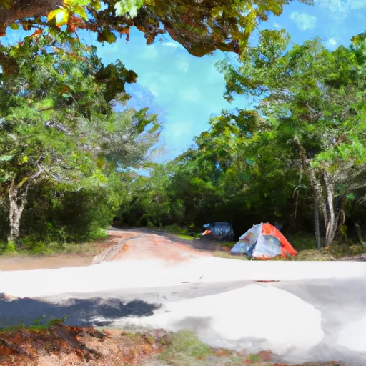
Magnolia County Park Campground
Community Reviews
Been here? Share the conditions.
Reviews, ratings & photos are added in the free Snoflo iOS app — rate a spot, tag the conditions, and your visit is verified by location. Add or manage your reviews from the app.
Magnolia County Park
Reservations are accepted at this campground, allowing campers to secure their spot ahead of time. This can be particularly beneficial during peak seasons when the campground tends to fill up quickly. It is advisable to check availability and make reservations in advance to guarantee a spot.
The best time to visit Magnolia County Park is during the cooler months, typically from October to April. The weather during this period is more pleasant and suitable for outdoor activities. Moreover, campers can take advantage of the lower humidity and fewer bugs during these months.
While camping at Magnolia County Park, there are a few things to be aware of. Mosquitoes can be quite prevalent in this area, especially during the warmer months, so it is recommended to bring insect repellent. Additionally, it is important to be cautious of wildlife in the surrounding area, such as snakes and alligators. Visitors should be mindful of their surroundings and follow all safety guidelines to ensure a safe and enjoyable camping experience at Magnolia County Park.
What's on-site at Magnolia County Park
Key facilities Snoflo tracks for this campground. Confirm with the operator before booking -- amenities can change seasonally.
Plan your trip down to the hour
Same weather feed Snoflo's iOS app uses -- updated continuously from NOAA / yr.no.
Next 5 days, hour by hour
Temperature line with weather symbols on top, snow + rain accumulation as columns, humidity as a dotted line.
5-day forecast table
Every 3 hours, broken out across temperature, snow, rain, humidity, and wind. Each cell is colour-coded relative to the column min/max so trends jump out at a glance.
| Time | Condition | Temp (°F) | Snow (in) | Rain (in) | Humidity (%) | Wind (mps) | Wind dir |
|---|---|---|---|---|---|---|---|
| Loading detailed forecast… | |||||||
15-day temperature & precipitation
Daily temperatures, snow, and rain projected over the next two weeks. Hover any point for the full breakdown.
Other campgrounds in the area
Snoflo-tracked campsites within driving distance of Magnolia County Park, with reservations status.
| Campground | Reservations | Toilets | View |
|---|---|---|---|
| Clarcona Horse Park | ✗ | ✗ | → |
| Wekiva Youth Camp | ✗ | ✗ | → |
| Campsites 1-30 | ✗ | ✗ | → |
| Campsites 31-60 | ✗ | ✗ | → |
| Wekiwa Springs State Park | ✓ | ✗ | → |
Nearby streamflow
USGS streamgauges within reach of Magnolia County Park -- pulled live from the National Water Information System.
| Streamgauge | Discharge | View |
|---|---|---|
| Apopka Flow-Way Feeder Canal Near Astatula | 7 cfs | → |
| Little Wekiva River Nr Altamonte Springs | 32 cfs | → |
| Apopka-Beauclair Canal Nr Astatula | 12 cfs | → |
| Wolf Branch At Fcrr Near Mount Dora | · | → |
| Howell Creek Nr Altamonte Springs | 5 cfs | → |
| Lateral-405 Ab S-405a | · | → |
Plan a longer trip
The closest parks, lakes, boat launches, and paddle runs so a camping night can grow into a full weekend.
Parks
- Clarcona Park
- Vignetti Park
- Wekiwa Springs Concession
- Lake Lotus Park
- Rose Place Park
- Oakland Nature Preserve
Boat launches
- South Binion Road 3002, Apopka
- North Lakeshore Drive 101-173, Ocoee
- North Lakeview Avenue 799, Winter Garden
- Abrams Avenue 17200, Montverde
- Dolores Drive, Pine Hills
- North Orange Blossom Trail 4503, Orlando
Fishing spots
Points of interest
- Apopka Wildlife Nature Drive
- Heritage Foundation History Center
- Bird Feeder
- Harry Potter And The Escape From Gringotts
- Orlando Gun Club
- Men In Black: Alien Attack
Paddle runs
- Segment A--Mouth Of Spring On Ocala Nf To Alexander Springs Wilderness Boundary
- Segment B--Alexander Springs Wilderness Boundary To Confluence With St. Johns River
- Segment A--Mouth Of Spring On Ocala Nf (At Juniper Springs Wilderness) To Bridge On Sh 19 (At Wilderness Boundary)
- Segment B--Bridge On Sh 19 To Confluence With Lake George
Camping essentials & Leave No Trace
- Pack it in, pack it out
- Take all trash, food scraps, and gear back with you to keep campsites clean and protect wildlife.
- Respect wildlife
- Observe animals from a distance, store food securely, and never feed wildlife to maintain natural behavior and safety.
- Know before you go
- Check weather, fire restrictions, trail conditions, and permit requirements to ensure a safe and well-planned trip.
- Minimize campfire impact
- Use established fire rings, keep fires small, fully extinguish them, or opt for a camp stove when fires are restricted.
- Leave what you find
- Preserve natural and cultural features by avoiding removal of plants, rocks, artifacts, or other elements of the environment.
Set push alerts in the Snoflo app
Save Magnolia County Park as a favorite, set a custom threshold (precipitation, snowpack, freezing temperatures), and the iOS app will push the moment conditions cross.
About Magnolia County Park
Can I make reservations at Magnolia County Park?
This campground does not appear to accept reservations -- it's typically first-come, first-served. Arrive early on summer weekends.
How fresh is the weather data on this page?
The hourly forecast updates throughout the day from the NOAA / yr.no public feeds. Streamflow data is pulled live from USGS streamgauges and snowpack from the NRCS SNOTEL network.
What's the best time of year to visit?
Use the 15-day temperature & precipitation outlook on this page to plan -- pick a window with comfortable temperatures and low precipitation. For longer trips, the 5-day hourly meteogram shows snow + rain accumulation hour-by-hour.
How do I get to Magnolia County Park?
Tap Directions in the hero above to open driving directions in Google Maps, or Open in map to center the Snoflo interactive map on the campground.
Can I get alerts when conditions change?
Yes -- alerts are managed through the Snoflo iOS app. Favorite this campground, set a threshold (temperature, snowpack, precipitation), and you'll get a push the moment it crosses.
Other campgrounds near here
Snoflo-tracked campgrounds within driving distance of Magnolia County Park.