Deep Hole Recreation Area campground
Community Reviews
Been here? Share the conditions.
Reviews, ratings & photos are added in the free Snoflo iOS app — rate a spot, tag the conditions, and your visit is verified by location. Add or manage your reviews from the app.
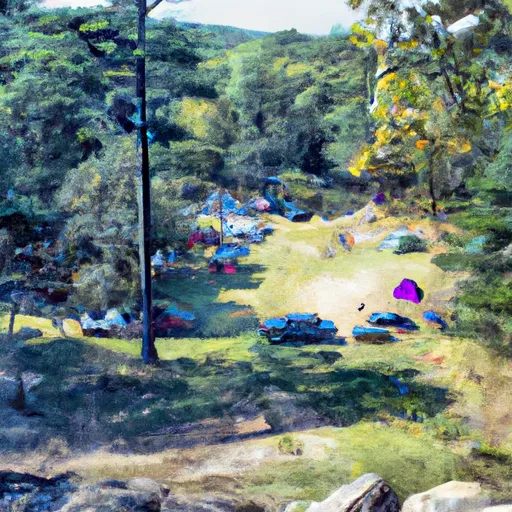
Deep Hole Recreation Area
Reservations are accepted at Deep Hole Recreation Area, allowing campers to secure their spot in advance. This is particularly recommended during the peak season, as the campground can get quite busy. Speaking of the best time to visit, it is advisable to plan a trip to this camping area during the warmer months, from spring to fall, when the weather is pleasant and conducive to outdoor activities.
While enjoying the beauty of Deep Hole Recreation Area, campers should be cautious of certain factors. It is important to be aware of wildlife in the area and take proper precautions to store food and dispose of waste responsibly to avoid any unwanted encounters. Additionally, campers should be cautious of potentially slippery paths near the river and pay attention to any safety signage or warnings provided by park authorities.
In conclusion, Deep Hole Recreation Area in Georgia offers a well-equipped camping area with amenities such as picnic tables, fire rings, and access to a nearby river. Reservations are accepted, and the best time to visit is during the warmer months. Campers should be mindful of wildlife and take necessary precautions, as well as be cautious of slippery paths near the river.
What's on-site at Deep Hole Recreation Area
Key facilities Snoflo tracks for this campground. Confirm with the operator before booking -- amenities can change seasonally.
Plan your trip down to the hour
Same weather feed Snoflo's iOS app uses -- updated continuously from NOAA / yr.no.
Next 5 days, hour by hour
Temperature line with weather symbols on top, snow + rain accumulation as columns, humidity as a dotted line.
5-day forecast table
Every 3 hours, broken out across temperature, snow, rain, humidity, and wind. Each cell is colour-coded relative to the column min/max so trends jump out at a glance.
| Time | Condition | Temp (°F) | Snow (in) | Rain (in) | Humidity (%) | Wind (mps) | Wind dir |
|---|---|---|---|---|---|---|---|
| Loading detailed forecast… | |||||||
15-day temperature & precipitation
Daily temperatures, snow, and rain projected over the next two weeks. Hover any point for the full breakdown.
Other campgrounds in the area
Snoflo-tracked campsites within driving distance of Deep Hole Recreation Area, with reservations status.
| Campground | Reservations | Toilets | View |
|---|---|---|---|
| Deep Hole | ✗ | ✗ | → |
| Hawk Mountain (Base) Campsite | ✗ | ✗ | → |
| Frank Gross | ✗ | ✗ | → |
| Frank Gross Recreation Area | ✓ | ✗ | → |
| Mulky Campground | ✗ | ✗ | → |
Nearby streamflow
USGS streamgauges within reach of Deep Hole Recreation Area -- pulled live from the National Water Information System.
| Streamgauge | Discharge | View |
|---|---|---|
| Toccoa River Near Dial | 276 cfs | → |
| Nottely River Near Blairsville | 227 cfs | → |
| Cartecay River Near Ellijay | 161 cfs | → |
| Chestatee River Near Dahlonega | 1,110 cfs | → |
| Coosawattee River Near Ellijay | 297 cfs | → |
| Ocoee River At Copperhill | 471 cfs | → |
Nearby snow depths
NRCS SNOTEL stations within reach of Deep Hole Recreation Area -- relevant when planning a shoulder-season or alpine trip.
| SNOTEL station | Snowpack | 24h Snowfall | View |
|---|---|---|---|
| Dahlonega | 0.0 in | 0.0 in | → |
| Sautee 3.5 Sw | 0.0 in | 0.0 in | → |
| Jasper | 0.0 in | 0.0 in | → |
| Germany Valley | 0.0 in | 0.0 in | → |
| Dillard 0.7 Nnw | 0.0 in | 0.0 in | → |
Plan a longer trip
The closest parks, lakes, boat launches, and paddle runs so a camping night can grow into a full weekend.
Parks
- Wilderness Blood Mountain
- Vogel State Park
- Wilderness Rich Mountain
- Amicalola Falls State Park
- Dahlonega Gold Museum Historic Site
- Lumpkin County Park
Boat launches
- Morganton Point
- Lake Blue Ridge Recreation Area
- Lake Blue Ridge Marina
- Mallard Point Road 109, Fannin County
- Jack's Creek Boat Ramp
- Tammen Park
Fishing spots
Points of interest
- Tasting Room
- World's Largest Amish Chair
- Paradise Valley Resort Tasting Room
- Bert's Farm
- Yahoola Cherokee Museum
- The Cottage Vineyard & Winery Tasting Room
Paddle runs
- Mark Trail Wilderness Boundry To Old Turnpike Crossing Near Vandiver Branch
- Old Turnpike Crossing To Martin Branch Bridge
- Source Near Chattahoochee Gap To Mark Trail Wilderness Boundary
- Martin Branch Bridge To Robertsontown Bridge On Ga Highway 356
- Source In Cohutta Wilderness To Nf Boundary North Of Murray's Lake
- Southern Boundary Cohutta Wilderness Near Peter Cove To Northern Boundary Cohutta Wilderness Near Alaculsy
Camping essentials & Leave No Trace
- Pack it in, pack it out
- Take all trash, food scraps, and gear back with you to keep campsites clean and protect wildlife.
- Respect wildlife
- Observe animals from a distance, store food securely, and never feed wildlife to maintain natural behavior and safety.
- Know before you go
- Check weather, fire restrictions, trail conditions, and permit requirements to ensure a safe and well-planned trip.
- Minimize campfire impact
- Use established fire rings, keep fires small, fully extinguish them, or opt for a camp stove when fires are restricted.
- Leave what you find
- Preserve natural and cultural features by avoiding removal of plants, rocks, artifacts, or other elements of the environment.
Set push alerts in the Snoflo app
Save Deep Hole Recreation Area as a favorite, set a custom threshold (precipitation, snowpack, freezing temperatures), and the iOS app will push the moment conditions cross.
About Deep Hole Recreation Area
Can I make reservations at Deep Hole Recreation Area?
This campground does not appear to accept reservations -- it's typically first-come, first-served. Arrive early on summer weekends.
How fresh is the weather data on this page?
The hourly forecast updates throughout the day from the NOAA / yr.no public feeds. Streamflow data is pulled live from USGS streamgauges and snowpack from the NRCS SNOTEL network.
What's the best time of year to visit?
Use the 15-day temperature & precipitation outlook on this page to plan -- pick a window with comfortable temperatures and low precipitation. For longer trips, the 5-day hourly meteogram shows snow + rain accumulation hour-by-hour.
How do I get to Deep Hole Recreation Area?
Tap Directions in the hero above to open driving directions in Google Maps, or Open in map to center the Snoflo interactive map on the campground.
Can I get alerts when conditions change?
Yes -- alerts are managed through the Snoflo iOS app. Favorite this campground, set a threshold (temperature, snowpack, precipitation), and you'll get a push the moment it crosses.
Other campgrounds near here
Snoflo-tracked campgrounds within driving distance of Deep Hole Recreation Area.