Upper Dry Gulch Campsite Campground
Community Reviews
Been here? Share the conditions.
Reviews, ratings & photos are added in the free Snoflo iOS app — rate a spot, tag the conditions, and your visit is verified by location. Add or manage your reviews from the app.
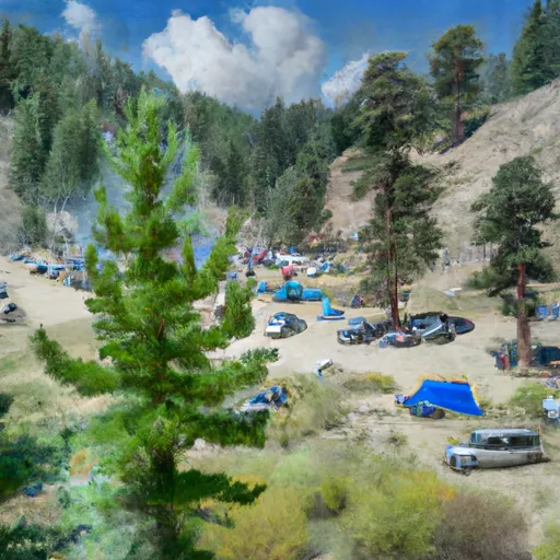
Upper Dry Gulch Campsite
The campsite offers several amenities, including picnic tables, fire pits, and restroom facilities. The area is available on a first-come, first-served basis, and the campsite offers ten campsites for visitors to choose from. With its serene and tranquil environment, the Upper Dry Gulch Campsite is a perfect spot for a getaway from the bustling city life.
An interesting fact about the area is that it is home to several hot springs in the region, which offer a chance to relax and unwind after a day of exploring the surrounding forests. The best time to visit the Upper Dry Gulch Campsite is during the summer months, between June and September, when the average temperature is around 75°F. Overall, the Upper Dry Gulch Campsite is an excellent camping destination for tourists who are looking for a peaceful and relaxing camping experience.
What's on-site at Upper Dry Gulch Campsite
Key facilities Snoflo tracks for this campground. Confirm with the operator before booking -- amenities can change seasonally.
Plan your trip down to the hour
Same weather feed Snoflo's iOS app uses -- updated continuously from NOAA / yr.no.
Next 5 days, hour by hour
Temperature line with weather symbols on top, snow + rain accumulation as columns, humidity as a dotted line.
5-day forecast table
Every 3 hours, broken out across temperature, snow, rain, humidity, and wind. Each cell is colour-coded relative to the column min/max so trends jump out at a glance.
| Time | Condition | Temp (°F) | Snow (in) | Rain (in) | Humidity (%) | Wind (mps) | Wind dir |
|---|---|---|---|---|---|---|---|
| Loading detailed forecast… | |||||||
15-day temperature & precipitation
Daily temperatures, snow, and rain projected over the next two weeks. Hover any point for the full breakdown.
Other campgrounds in the area
Snoflo-tracked campsites within driving distance of Upper Dry Gulch Campsite, with reservations status.
| Campground | Reservations | Toilets | View |
|---|---|---|---|
| Lower Oregon Hole Campsite | ✗ | ✗ | → |
| Upper Oregon Hole Campsite | ✗ | ✗ | → |
| Hastings Campsite | ✗ | ✗ | → |
| Three Creek Campsite | ✗ | ✗ | → |
| Saddle Creek Campsite | ✗ | ✗ | → |
Nearby streamflow
USGS streamgauges within reach of Upper Dry Gulch Campsite -- pulled live from the National Water Information System.
| Streamgauge | Discharge | View |
|---|---|---|
| Snake River At Hells Canyon Dam Id-Or State Line | 19,200 cfs | → |
| Little Salmon River At Riggins Id | 253 cfs | → |
| Imnaha River At Imnaha | 150 cfs | → |
| Salmon River At White Bird Id | 6,620 cfs | → |
| Nf Payette River At Mccall Id | 55 cfs | → |
| Lake Fork Payette River Ab Jumbo Cr Nr Mccall Id | 43 cfs | → |
Nearby snow depths
NRCS SNOTEL stations within reach of Upper Dry Gulch Campsite -- relevant when planning a shoulder-season or alpine trip.
| SNOTEL station | Snowpack | 24h Snowfall | View |
|---|---|---|---|
| Lucile 1.2 Nne | 0.0 in | 0.0 in | → |
| West Branch | 1.0 in | 0.0 in | → |
| Nohrsc West Branch | 2.0 in | 0.0 in | → |
| Mt. Howard | 0.0 in | 0.0 in | → |
| Nohrsc Mt. Howard | 1.0 in | 0.0 in | → |
| Joseph | 0.0 in | 0.0 in | → |
Plan a longer trip
The closest parks, lakes, boat launches, and paddle runs so a camping night can grow into a full weekend.
Parks
- National Wild And Scenic River Snake, Idaho And Oregon
- Wilderness Hells Canyon
- Iwetemlaykin State Heritage Site
- Wallowa Lake State Park
- Nez Perce National Historic Park-Confluence Overlook
- Hells Canyon National Recreation Area
Boat launches
- Hells Canyon Creek Recreation Site
- Main Street Idaho County
- National Forest Development Road 1614 Idaho County
- Us 95 Idaho County
- Allison Creek Trail Adams County
Camping essentials & Leave No Trace
- Pack it in, pack it out
- Take all trash, food scraps, and gear back with you to keep campsites clean and protect wildlife.
- Respect wildlife
- Observe animals from a distance, store food securely, and never feed wildlife to maintain natural behavior and safety.
- Know before you go
- Check weather, fire restrictions, trail conditions, and permit requirements to ensure a safe and well-planned trip.
- Minimize campfire impact
- Use established fire rings, keep fires small, fully extinguish them, or opt for a camp stove when fires are restricted.
- Leave what you find
- Preserve natural and cultural features by avoiding removal of plants, rocks, artifacts, or other elements of the environment.
Set push alerts in the Snoflo app
Save Upper Dry Gulch Campsite as a favorite, set a custom threshold (precipitation, snowpack, freezing temperatures), and the iOS app will push the moment conditions cross.
About Upper Dry Gulch Campsite
Can I make reservations at Upper Dry Gulch Campsite?
This campground does not appear to accept reservations -- it's typically first-come, first-served. Arrive early on summer weekends.
How fresh is the weather data on this page?
The hourly forecast updates throughout the day from the NOAA / yr.no public feeds. Streamflow data is pulled live from USGS streamgauges and snowpack from the NRCS SNOTEL network.
What's the best time of year to visit?
Use the 15-day temperature & precipitation outlook on this page to plan -- pick a window with comfortable temperatures and low precipitation. For longer trips, the 5-day hourly meteogram shows snow + rain accumulation hour-by-hour.
How do I get to Upper Dry Gulch Campsite?
Tap Directions in the hero above to open driving directions in Google Maps, or Open in map to center the Snoflo interactive map on the campground.
Can I get alerts when conditions change?
Yes -- alerts are managed through the Snoflo iOS app. Favorite this campground, set a threshold (temperature, snowpack, precipitation), and you'll get a push the moment it crosses.
Other campgrounds near here
Snoflo-tracked campgrounds within driving distance of Upper Dry Gulch Campsite.