Sutton Bluff Campground
Community Reviews
Been here? Share the conditions.
Reviews, ratings & photos are added in the free Snoflo iOS app — rate a spot, tag the conditions, and your visit is verified by location. Add or manage your reviews from the app.
Sutton Bluff
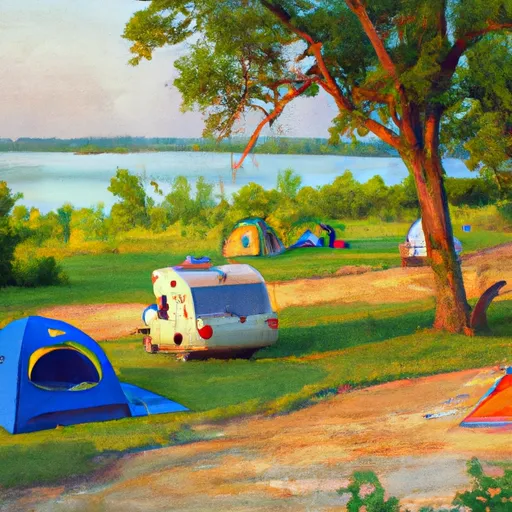
The campground has 27 campsites with electrical hookups and access to water. The amenities include a dump station, hot showers, and flushing toilets. The campground is first-come-first-serve and does not offer reservations.
An interesting fact about the area is that it was once home to the Missouri Iron Company, which operated a large furnace that produced iron for the Civil War.
The best time of year to visit Sutton Bluff is during the spring or fall when the temperatures are mild. The average temperature in the spring (April-June) is around 60-70°F, and in the fall (September-November) is around 50-60°F. It's important to note that the campground is closed during the winter months from December through February. Overall, Sutton Bluff camping area is a great place to enjoy the beautiful scenery of the Ozarks and explore nearby state parks.
What's on-site at Sutton Bluff
Key facilities Snoflo tracks for this campground. Confirm with the operator before booking -- amenities can change seasonally.
Plan your trip down to the hour
Same weather feed Snoflo's iOS app uses -- updated continuously from NOAA / yr.no.
Next 5 days, hour by hour
Temperature line with weather symbols on top, snow + rain accumulation as columns, humidity as a dotted line.
5-day forecast table
Every 3 hours, broken out across temperature, snow, rain, humidity, and wind. Each cell is colour-coded relative to the column min/max so trends jump out at a glance.
| Time | Condition | Temp (°F) | Snow (in) | Rain (in) | Humidity (%) | Wind (mps) | Wind dir |
|---|---|---|---|---|---|---|---|
| Loading detailed forecast… | |||||||
15-day temperature & precipitation
Daily temperatures, snow, and rain projected over the next two weeks. Hover any point for the full breakdown.
Other campgrounds in the area
Snoflo-tracked campsites within driving distance of Sutton Bluff, with reservations status.
| Campground | Reservations | Toilets | View |
|---|---|---|---|
| Sutton Bluff Recreation Area | ✓ | ✗ | → |
| Park's Bluff | ✗ | ✗ | → |
| Johnsons Shut-Ins State Park | ✓ | ✓ | → |
| Ozark Trail Gunstock Hollow | ✗ | ✗ | → |
| Panther Branch | ✗ | ✗ | → |
Nearby streamflow
USGS streamgauges within reach of Sutton Bluff -- pulled live from the National Water Information System.
| Streamgauge | Discharge | View |
|---|---|---|
| East Fork Black River At Lesterville | 44 cfs | → |
| East Fork Black River Nr Lesterville | 1 cfs | → |
| Black River Near Annapolis | 307 cfs | → |
| Logan Creek At Ellington | 6 cfs | → |
| Jacks Fork At Eminence | 131 cfs | → |
| St. Francis River Near Saco | 70 cfs | → |
Nearby snow depths
NRCS SNOTEL stations within reach of Sutton Bluff -- relevant when planning a shoulder-season or alpine trip.
| SNOTEL station | Snowpack | 24h Snowfall | View |
|---|---|---|---|
| Clearwater Dam - Black Rvr | 0.0 in | 0.0 in | → |
Plan a longer trip
The closest parks, lakes, boat launches, and paddle runs so a camping night can grow into a full weekend.
Parks
- Johnson's Shut-Ins State Park
- Wilderness Bell Mountain
- Taum Sauk Mountain State Park
- Conservation Area Ketcherside Mountain
- Logan Creek Conservation Area
- Elephant Rocks State Park
Boat launches
- Enough Boat Launch And Trailhead
- Council Bluff Lake Trail Washington County
- Ozark Trail - Marble Creek Section Iron County
- Bluff View
- Shannon County
- Two Rivers Access (Ozark National Scenic Riverways)
Fishing spots
Points of interest
- Taum Sauk Nature Museum
- Mina Sauk Falls
- Memorial
- Engine House Ruin
- Fort Davidson
- Round Spring Visitor Center
Paddle runs
- Forest Boundary At North Section Line Of Sec 4, T33n, R5e To Forest Boundary At South Section Line Of Sec 35, T32n, R5e
- Confluence With Alley Spring (Branch) To Confluence With Current River (Does Not Include River Segment In Gap Between Parkland Units)
- The Most Upstream Portion Of Ozark National Scenic Riverways To The Most Downstream Portion Of Ozark National Scenic Riverways
- Markam Spring Recreation Area To Nf Boundary
- State Highway 49 Bridge Near Dillard, Missouri To Forest Boundary In Sections 13/24, T38n, R3w
Camping essentials & Leave No Trace
- Pack it in, pack it out
- Take all trash, food scraps, and gear back with you to keep campsites clean and protect wildlife.
- Respect wildlife
- Observe animals from a distance, store food securely, and never feed wildlife to maintain natural behavior and safety.
- Know before you go
- Check weather, fire restrictions, trail conditions, and permit requirements to ensure a safe and well-planned trip.
- Minimize campfire impact
- Use established fire rings, keep fires small, fully extinguish them, or opt for a camp stove when fires are restricted.
- Leave what you find
- Preserve natural and cultural features by avoiding removal of plants, rocks, artifacts, or other elements of the environment.
Set push alerts in the Snoflo app
Save Sutton Bluff as a favorite, set a custom threshold (precipitation, snowpack, freezing temperatures), and the iOS app will push the moment conditions cross.
About Sutton Bluff
Can I make reservations at Sutton Bluff?
Yes -- this campground accepts reservations. Snoflo recommends booking early for peak season; check the operator (Recreation.gov / state park system / private operator) for the booking window and cancellation policy.
How fresh is the weather data on this page?
The hourly forecast updates throughout the day from the NOAA / yr.no public feeds. Streamflow data is pulled live from USGS streamgauges and snowpack from the NRCS SNOTEL network.
What's the best time of year to visit?
Use the 15-day temperature & precipitation outlook on this page to plan -- pick a window with comfortable temperatures and low precipitation. For longer trips, the 5-day hourly meteogram shows snow + rain accumulation hour-by-hour.
How do I get to Sutton Bluff?
Tap Directions in the hero above to open driving directions in Google Maps, or Open in map to center the Snoflo interactive map on the campground.
Can I get alerts when conditions change?
Yes -- alerts are managed through the Snoflo iOS app. Favorite this campground, set a threshold (temperature, snowpack, precipitation), and you'll get a push the moment it crosses.
Other campgrounds near here
Snoflo-tracked campgrounds within driving distance of Sutton Bluff.