Cold Creek- State Forest Campground
Community Reviews
Been here? Share the conditions.
Reviews, ratings & photos are added in the free Snoflo iOS app — rate a spot, tag the conditions, and your visit is verified by location. Add or manage your reviews from the app.
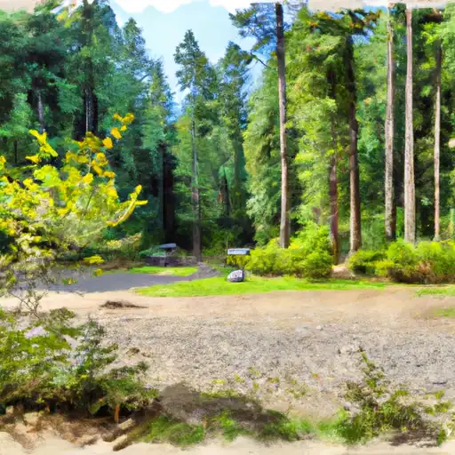
Cold Creek- State Forest
Reservations are required for camping at Cold Creek State Forest, ensuring that campers have a designated spot upon arrival. It is advised to book well in advance due to the campground's popularity. The best time to visit this camping area is during the summer months, from June to September, when the weather is pleasant for outdoor activities and exploring the surrounding nature.
While camping at Cold Creek State Forest, there are a few things to be cautious of. It is important to be mindful of wildlife in the area, including bears and other potentially dangerous animals. Proper food storage techniques should be followed to prevent attracting wildlife to campsites. Additionally, campers should be prepared for sudden weather changes, as Washington's climate can be unpredictable. Overall, Cold Creek State Forest camping area offers a picturesque setting for nature lovers seeking a peaceful camping experience in Washington State.
What's on-site at Cold Creek- State Forest
Key facilities Snoflo tracks for this campground. Confirm with the operator before booking -- amenities can change seasonally.
Plan your trip down to the hour
Same weather feed Snoflo's iOS app uses -- updated continuously from NOAA / yr.no.
Next 5 days, hour by hour
Temperature line with weather symbols on top, snow + rain accumulation as columns, humidity as a dotted line.
5-day forecast table
Every 3 hours, broken out across temperature, snow, rain, humidity, and wind. Each cell is colour-coded relative to the column min/max so trends jump out at a glance.
| Time | Condition | Temp (°F) | Snow (in) | Rain (in) | Humidity (%) | Wind (mps) | Wind dir |
|---|---|---|---|---|---|---|---|
| Loading detailed forecast… | |||||||
15-day temperature & precipitation
Daily temperatures, snow, and rain projected over the next two weeks. Hover any point for the full breakdown.
Other campgrounds in the area
Snoflo-tracked campsites within driving distance of Cold Creek- State Forest, with reservations status.
| Campground | Reservations | Toilets | View |
|---|---|---|---|
| Copper City Campsite | ✗ | ✗ | → |
| Campground: Sunset Falls Campground And Day Use | ✓ | ✗ | → |
| Battle Ground Lake State Park | ✓ | ✗ | → |
| Hike/Bike | ✗ | ✗ | → |
| Doughgob Camp | ✗ | ✗ | → |
Nearby streamflow
USGS streamgauges within reach of Cold Creek- State Forest -- pulled live from the National Water Information System.
| Streamgauge | Discharge | View |
|---|---|---|
| East Fork Lewis River Near Heisson | 68 cfs | → |
| Canyon Creek Near Amboy | 32 cfs | → |
| Beaver Creek At Troutdale | 1 cfs | → |
| Fairview Creek At Glisan St Near Gresham | 1 cfs | → |
| Lewis River At Ariel | 1,410 cfs | → |
| Speelyai Creek Near Cougar | 5 cfs | → |
Nearby snow depths
NRCS SNOTEL stations within reach of Cold Creek- State Forest -- relevant when planning a shoulder-season or alpine trip.
| SNOTEL station | Snowpack | 24h Snowfall | View |
|---|---|---|---|
| Calamity | 0.0 in | 0.0 in | → |
| Bonneville Dam | 0.0 in | 0.0 in | → |
| Nohrsc North Fork | 0.0 in | 0.0 in | → |
| North Fork | 0.0 in | 0.0 in | → |
| Cascade Locks | 0.0 in | 0.0 in | → |
| Headworks Portland Water Bureau | 0.0 in | 0.0 in | → |
Plan a longer trip
The closest parks, lakes, boat launches, and paddle runs so a camping night can grow into a full weekend.
Parks
- Wilderness Cranberry
- Droop Mountain Battlefield State Park
- Watoga State Park
- Seneca State Forest
- Cass Scenic Railroad State Park
- Beartown State Park
Boat launches
- Handley Water Management Area Lake
- Summit Lake Trail No 201 Greenbrier County
- Watoga State Park Lake
- Big Ditch Lake
- Renick
- Lake Sherwood Road Greenbrier County
Camping essentials & Leave No Trace
- Pack it in, pack it out
- Take all trash, food scraps, and gear back with you to keep campsites clean and protect wildlife.
- Respect wildlife
- Observe animals from a distance, store food securely, and never feed wildlife to maintain natural behavior and safety.
- Know before you go
- Check weather, fire restrictions, trail conditions, and permit requirements to ensure a safe and well-planned trip.
- Minimize campfire impact
- Use established fire rings, keep fires small, fully extinguish them, or opt for a camp stove when fires are restricted.
- Leave what you find
- Preserve natural and cultural features by avoiding removal of plants, rocks, artifacts, or other elements of the environment.
Set push alerts in the Snoflo app
Save Cold Creek- State Forest as a favorite, set a custom threshold (precipitation, snowpack, freezing temperatures), and the iOS app will push the moment conditions cross.
About Cold Creek- State Forest
Can I make reservations at Cold Creek- State Forest?
This campground does not appear to accept reservations -- it's typically first-come, first-served. Arrive early on summer weekends.
How fresh is the weather data on this page?
The hourly forecast updates throughout the day from the NOAA / yr.no public feeds. Streamflow data is pulled live from USGS streamgauges and snowpack from the NRCS SNOTEL network.
What's the best time of year to visit?
Use the 15-day temperature & precipitation outlook on this page to plan -- pick a window with comfortable temperatures and low precipitation. For longer trips, the 5-day hourly meteogram shows snow + rain accumulation hour-by-hour.
How do I get to Cold Creek- State Forest?
Tap Directions in the hero above to open driving directions in Google Maps, or Open in map to center the Snoflo interactive map on the campground.
Can I get alerts when conditions change?
Yes -- alerts are managed through the Snoflo iOS app. Favorite this campground, set a threshold (temperature, snowpack, precipitation), and you'll get a push the moment it crosses.
Other campgrounds near here
Snoflo-tracked campgrounds within driving distance of Cold Creek- State Forest.