Succor Creek State Natural Area Campground
Community Reviews
Been here? Share the conditions.
Reviews, ratings & photos are added in the free Snoflo iOS app — rate a spot, tag the conditions, and your visit is verified by location. Add or manage your reviews from the app.
Succor Creek State Natural Area
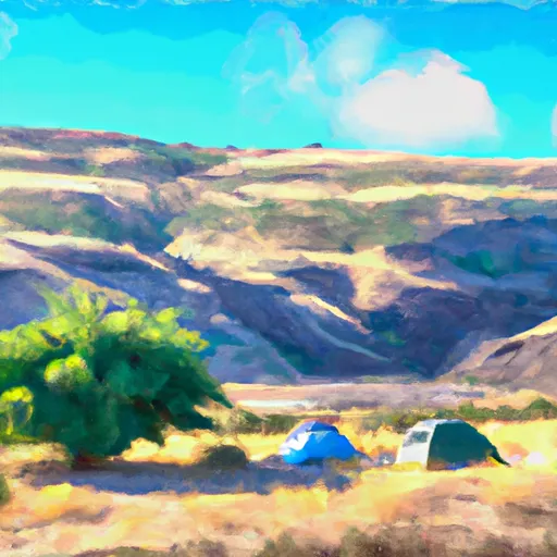
Reservations at Succor Creek State Natural Area are not accepted, and campsites operate on a first-come, first-served basis. It is advisable to arrive early, especially during peak seasons, to secure a desired spot. The best time to visit this camping area is during the spring or fall when temperatures are mild and the landscape is adorned with vibrant wildflowers or colorful foliage.
Campers at Succor Creek State Natural Area are in for a treat as there are several points of interest to explore. The area is renowned for its striking rock formations, such as the towering Succor Creek Canyon walls. Hiking enthusiasts can traverse the various trails that wind through the canyon, offering stunning views and opportunities to spot wildlife. However, caution must be exercised as the trails can be rugged and steep, requiring proper footwear and navigation skills.
In summary, Succor Creek State Natural Area in Oregon is an excellent camping destination for those seeking a tranquil and scenic getaway. With its basic amenities, first-come, first-served campsites, and picturesque surroundings, it offers an immersive outdoor experience. Whether enjoying the vibrant spring wildflowers or the fall foliage, adventurers can explore the captivating rock formations and hike the scenic trails. However, visitors should come prepared with their own supplies and be cautious while navigating the rugged terrain.
What's on-site at Succor Creek State Natural Area
Key facilities Snoflo tracks for this campground. Confirm with the operator before booking -- amenities can change seasonally.
Plan your trip down to the hour
Same weather feed Snoflo's iOS app uses -- updated continuously from NOAA / yr.no.
Next 5 days, hour by hour
Temperature line with weather symbols on top, snow + rain accumulation as columns, humidity as a dotted line.
5-day forecast table
Every 3 hours, broken out across temperature, snow, rain, humidity, and wind. Each cell is colour-coded relative to the column min/max so trends jump out at a glance.
| Time | Condition | Temp (°F) | Snow (in) | Rain (in) | Humidity (%) | Wind (mps) | Wind dir |
|---|---|---|---|---|---|---|---|
| Loading detailed forecast… | |||||||
15-day temperature & precipitation
Daily temperatures, snow, and rain projected over the next two weeks. Hover any point for the full breakdown.
Other campgrounds in the area
Snoflo-tracked campsites within driving distance of Succor Creek State Natural Area, with reservations status.
| Campground | Reservations | Toilets | View |
|---|---|---|---|
| Lake Owyhee State Park | ✓ | ✗ | → |
| Slocum Creek Campground | ✗ | ✗ | → |
| Leslie Gulch Site | ✗ | ✗ | → |
| Basque | ✗ | ✗ | → |
| Parma City Park - Old Fort Boise | ✗ | ✗ | → |
Nearby streamflow
USGS streamgauges within reach of Succor Creek State Natural Area -- pulled live from the National Water Information System.
| Streamgauge | Discharge | View |
|---|---|---|
| Owyhee River Below Owyhee Dam Or | 118 cfs | → |
| Dixie Drain Nr Wilder Id | 149 cfs | → |
| Boise River Nr Parma Id | 510 cfs | → |
| Sand Run Gulch Nr Parma Id | 119 cfs | → |
| Conway Gulch Below 1st St At Notus | 31 cfs | → |
| Boise River At Caldwell | 278 cfs | → |
Nearby snow depths
NRCS SNOTEL stations within reach of Succor Creek State Natural Area -- relevant when planning a shoulder-season or alpine trip.
| SNOTEL station | Snowpack | 24h Snowfall | View |
|---|---|---|---|
| Homedale 4.0 Wnw | 0.0 in | 0.0 in | → |
| Homedale 1 Se | 0.0 in | 0.0 in | → |
| Reynolds Creek | 0.0 in | 0.0 in | → |
| Nohrsc Reynolds Creek | 0.0 in | 0.0 in | → |
| Meridian 4.8 Sse | 0.0 in | 0.0 in | → |
| Meridian 3.9 Se | 0.0 in | 0.0 in | → |
Plan a longer trip
The closest parks, lakes, boat launches, and paddle runs so a camping night can grow into a full weekend.
Parks
- Succor Creek State Natural Area
- Lake Owyhee State Park
- Old Fort Boise Park
- Sebree Park
- Whitenberger Park
- Luby Park
Boat launches
- Indian Creek Campground
- Gordon Gulch Day Use
- Mccormack Campground
- Lake Owyhee Dam Ramp
- Leslie Gulch
- Leslie Gulch Road Malheur County
Camping essentials & Leave No Trace
- Pack it in, pack it out
- Take all trash, food scraps, and gear back with you to keep campsites clean and protect wildlife.
- Respect wildlife
- Observe animals from a distance, store food securely, and never feed wildlife to maintain natural behavior and safety.
- Know before you go
- Check weather, fire restrictions, trail conditions, and permit requirements to ensure a safe and well-planned trip.
- Minimize campfire impact
- Use established fire rings, keep fires small, fully extinguish them, or opt for a camp stove when fires are restricted.
- Leave what you find
- Preserve natural and cultural features by avoiding removal of plants, rocks, artifacts, or other elements of the environment.
Set push alerts in the Snoflo app
Save Succor Creek State Natural Area as a favorite, set a custom threshold (precipitation, snowpack, freezing temperatures), and the iOS app will push the moment conditions cross.
About Succor Creek State Natural Area
Can I make reservations at Succor Creek State Natural Area?
This campground does not appear to accept reservations -- it's typically first-come, first-served. Arrive early on summer weekends.
How fresh is the weather data on this page?
The hourly forecast updates throughout the day from the NOAA / yr.no public feeds. Streamflow data is pulled live from USGS streamgauges and snowpack from the NRCS SNOTEL network.
What's the best time of year to visit?
Use the 15-day temperature & precipitation outlook on this page to plan -- pick a window with comfortable temperatures and low precipitation. For longer trips, the 5-day hourly meteogram shows snow + rain accumulation hour-by-hour.
How do I get to Succor Creek State Natural Area?
Tap Directions in the hero above to open driving directions in Google Maps, or Open in map to center the Snoflo interactive map on the campground.
Can I get alerts when conditions change?
Yes -- alerts are managed through the Snoflo iOS app. Favorite this campground, set a threshold (temperature, snowpack, precipitation), and you'll get a push the moment it crosses.
Other campgrounds near here
Snoflo-tracked campgrounds within driving distance of Succor Creek State Natural Area.