Vincent Creek Campground
Community Reviews
Been here? Share the conditions.
Reviews, ratings & photos are added in the free Snoflo iOS app — rate a spot, tag the conditions, and your visit is verified by location. Add or manage your reviews from the app.
Vincent Creek
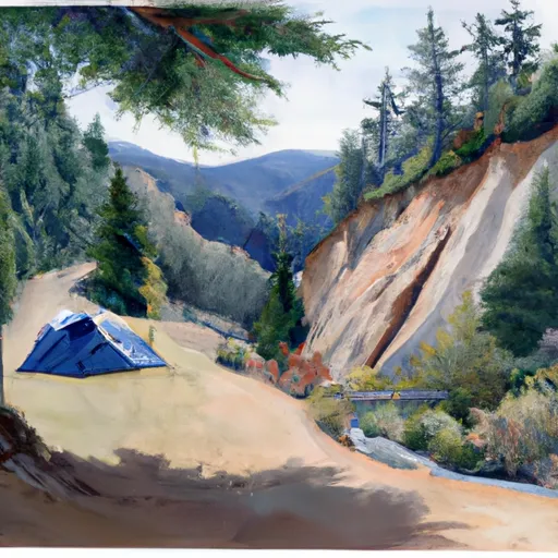
The campground amenities include picnic tables, fire pits, and vault toilets. There are 15 campsites available on a first-come-first-serve basis, making it an ideal spot for spontaneous camping trips. An interesting fact about the area is that it was once a logging camp before being converted to a campground.
The best time to visit Vincent Creek Camping Area is during the summer months, from June to August, with average temperatures ranging from the mid-70s to low 80s Fahrenheit. However, visitors should be prepared for occasional rain showers.
Overall, the Vincent Creek Camping Area is a great destination for nature lovers who want to escape the hustle and bustle of city life and enjoy the peace and quiet of the great outdoors.
What's on-site at Vincent Creek
Key facilities Snoflo tracks for this campground. Confirm with the operator before booking -- amenities can change seasonally.
Plan your trip down to the hour
Same weather feed Snoflo's iOS app uses -- updated continuously from NOAA / yr.no.
Next 5 days, hour by hour
Temperature line with weather symbols on top, snow + rain accumulation as columns, humidity as a dotted line.
5-day forecast table
Every 3 hours, broken out across temperature, snow, rain, humidity, and wind. Each cell is colour-coded relative to the column min/max so trends jump out at a glance.
| Time | Condition | Temp (°F) | Snow (in) | Rain (in) | Humidity (%) | Wind (mps) | Wind dir |
|---|---|---|---|---|---|---|---|
| Loading detailed forecast… | |||||||
15-day temperature & precipitation
Daily temperatures, snow, and rain projected over the next two weeks. Hover any point for the full breakdown.
Other campgrounds in the area
Snoflo-tracked campsites within driving distance of Vincent Creek, with reservations status.
| Campground | Reservations | Toilets | View |
|---|---|---|---|
| Vincent Creek Campground | ✗ | ✗ | → |
| Vincent Creek Recreation Site | ✗ | ✗ | → |
| Smith River Falls Campground | ✗ | ✗ | → |
| Smith River Falls Recreation Site | ✗ | ✗ | → |
| Smith River Falls | ✗ | ✗ | → |
Nearby streamflow
USGS streamgauges within reach of Vincent Creek -- pulled live from the National Water Information System.
| Streamgauge | Discharge | View |
|---|---|---|
| Umpqua River Near Elkton | 798 cfs | → |
| Siuslaw River Near Mapleton | 107 cfs | → |
| Long Tom River Near Noti | 14 cfs | → |
| Little Wolf Creek Near Tyee | 0 cfs | → |
| East Fork Lobster Creek Near Alsea | 1 cfs | → |
| Long Tom River Near Alvadore | 62 cfs | → |
Nearby snow depths
NRCS SNOTEL stations within reach of Vincent Creek -- relevant when planning a shoulder-season or alpine trip.
| SNOTEL station | Snowpack | 24h Snowfall | View |
|---|---|---|---|
| Eugene-Mahlon Sweet Field | 0.0 in | 0.0 in | → |
| Cottage Grove 2e | 0.0 in | 0.0 in | → |
Plan a longer trip
The closest parks, lakes, boat launches, and paddle runs so a camping night can grow into a full weekend.
Parks
- Scottsburg Park
- Umpqua Myrtle State Park
- Siuslaw National Forest
- Umpqua State Scenic Corridor
- Umpqua Myrtle State Natural Site
- Ada Park
Boat launches
Points of interest
- Whittaker Creek Campground Watchable Wildlife
- Siuslaw River Viewpoint
- Gardiner Historic District
- Sand Dunes Frontier
- The Laughing Crab Gallery & Tasting Room
- Siuslaw Vista Day Use
Paddle runs
- East Section Line Of Ne1/4se1/4 Of Sec 16, T21s, R10w To Confluence With Smith River
- Confluence With Jump Creek To East Section Line Of Sec 36, T19s, R10w
- East Section Line Of Sec 36, T19s, R10w To South Section Line Of Sec 32, T19s, R10w
- Eastern Siuslaw Nf Boundary To East Section Line Of Ne1/4se1/4 Of Sec 16, T21s, R10w
- Eastern Siuslaw Nf Boundary To Confluence With Jump Creek
- Siuslaw River Seg C
Camping essentials & Leave No Trace
- Pack it in, pack it out
- Take all trash, food scraps, and gear back with you to keep campsites clean and protect wildlife.
- Respect wildlife
- Observe animals from a distance, store food securely, and never feed wildlife to maintain natural behavior and safety.
- Know before you go
- Check weather, fire restrictions, trail conditions, and permit requirements to ensure a safe and well-planned trip.
- Minimize campfire impact
- Use established fire rings, keep fires small, fully extinguish them, or opt for a camp stove when fires are restricted.
- Leave what you find
- Preserve natural and cultural features by avoiding removal of plants, rocks, artifacts, or other elements of the environment.
Set push alerts in the Snoflo app
Save Vincent Creek as a favorite, set a custom threshold (precipitation, snowpack, freezing temperatures), and the iOS app will push the moment conditions cross.
About Vincent Creek
Can I make reservations at Vincent Creek?
This campground does not appear to accept reservations -- it's typically first-come, first-served. Arrive early on summer weekends.
How fresh is the weather data on this page?
The hourly forecast updates throughout the day from the NOAA / yr.no public feeds. Streamflow data is pulled live from USGS streamgauges and snowpack from the NRCS SNOTEL network.
What's the best time of year to visit?
Use the 15-day temperature & precipitation outlook on this page to plan -- pick a window with comfortable temperatures and low precipitation. For longer trips, the 5-day hourly meteogram shows snow + rain accumulation hour-by-hour.
How do I get to Vincent Creek?
Tap Directions in the hero above to open driving directions in Google Maps, or Open in map to center the Snoflo interactive map on the campground.
Can I get alerts when conditions change?
Yes -- alerts are managed through the Snoflo iOS app. Favorite this campground, set a threshold (temperature, snowpack, precipitation), and you'll get a push the moment it crosses.
Other campgrounds near here
Snoflo-tracked campgrounds within driving distance of Vincent Creek.