Devils Canyon Campground
Community Reviews
Been here? Share the conditions.
Reviews, ratings & photos are added in the free Snoflo iOS app — rate a spot, tag the conditions, and your visit is verified by location. Add or manage your reviews from the app.
Devils Canyon
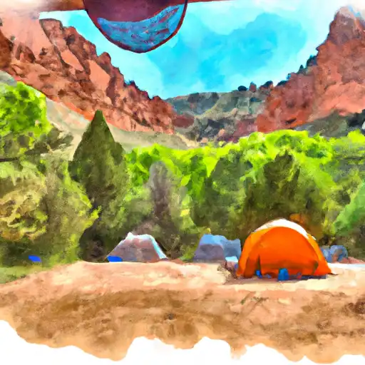
While Devils Canyon camping area provides a back-to-nature experience, it also offers some basic amenities to enhance the camping experience. These include picnic tables, fire rings, and vault toilets. However, there is no potable water available, so campers must bring their own supply. Additionally, the campground does not offer any electrical hookups or shower facilities.
Reservations are not accepted at Devils Canyon camping area, as the sites are available on a first-come, first-served basis. It is advisable to arrive early, particularly during peak season, to secure a spot. The best time to visit this campground is during the spring and fall months when the weather is mild and temperatures are comfortable. Summers can be scorching hot, while winters bring cold temperatures and occasional snowfall.
While exploring Devils Canyon camping area, campers should be cautious of the rugged terrain and steep cliffs. It is important to stay on designated trails and avoid venturing too close to the edges. Wildlife encounters are common in this area, so campers should store food securely and respect the natural habitat. Overall, Devils Canyon camping area is a haven for nature lovers seeking a rustic camping experience immersed in the stunning landscapes of Utah.
What's on-site at Devils Canyon
Key facilities Snoflo tracks for this campground. Confirm with the operator before booking -- amenities can change seasonally.
Plan your trip down to the hour
Same weather feed Snoflo's iOS app uses -- updated continuously from NOAA / yr.no.
Next 5 days, hour by hour
Temperature line with weather symbols on top, snow + rain accumulation as columns, humidity as a dotted line.
5-day forecast table
Every 3 hours, broken out across temperature, snow, rain, humidity, and wind. Each cell is colour-coded relative to the column min/max so trends jump out at a glance.
| Time | Condition | Temp (°F) | Snow (in) | Rain (in) | Humidity (%) | Wind (mps) | Wind dir |
|---|---|---|---|---|---|---|---|
| Loading detailed forecast… | |||||||
15-day temperature & precipitation
Daily temperatures, snow, and rain projected over the next two weeks. Hover any point for the full breakdown.
Other campgrounds in the area
Snoflo-tracked campsites within driving distance of Devils Canyon, with reservations status.
| Campground | Reservations | Toilets | View |
|---|---|---|---|
| Devils Canyon Campground | ✓ | ✗ | → |
| Nizhoni Campground | ✗ | ✗ | → |
| Nizhoni | ✓ | ✓ | → |
| Free Camping | ✗ | ✗ | → |
| Westerner Trailer Park | ✗ | ✗ | → |
Nearby streamflow
USGS streamgauges within reach of Devils Canyon -- pulled live from the National Water Information System.
| Streamgauge | Discharge | View |
|---|---|---|
| Recapture Creek Near Blanding | · | → |
| South Creek Above Reservoir Near Monticello | 0 cfs | → |
| Dolores River Near Slick Rock | 2 cfs | → |
| Mcelmo Creek Near Colorado-Utah State Line | 3 cfs | → |
| San Juan River Near Bluff | 763 cfs | → |
| Mcelmo Creek Above Trail Canyon Near Cortez | 25 cfs | → |
Nearby snow depths
NRCS SNOTEL stations within reach of Devils Canyon -- relevant when planning a shoulder-season or alpine trip.
| SNOTEL station | Snowpack | 24h Snowfall | View |
|---|---|---|---|
| Camp Jackson | 0.0 in | 0.0 in | → |
| Camp Jackson | 0.0 in | 0.0 in | → |
| Buckboard Flat | 0.0 in | 0.0 in | → |
| Buckboard Flat | 0.0 in | 0.0 in | → |
| Hovenweep National Monument | 0.0 in | 0.0 in | → |
| Bluff | 0.0 in | 0.0 in | → |
Plan a longer trip
The closest parks, lakes, boat launches, and paddle runs so a camping night can grow into a full weekend.
Parks
- Edge Of The Cedars State Park
- Wilderness Dark Canyon
- Manti La Sal National Forest
- Hovenweep National Monument-Square Tower
- Natural Bridges National Monument
Fishing spots
- Dry Wash Reservoir
- Monticello Lake Fishing Site
- Narraguinnep Reservoir
- Medicine Lake
- Mcphee Reservoir
Points of interest
Camping essentials & Leave No Trace
- Pack it in, pack it out
- Take all trash, food scraps, and gear back with you to keep campsites clean and protect wildlife.
- Respect wildlife
- Observe animals from a distance, store food securely, and never feed wildlife to maintain natural behavior and safety.
- Know before you go
- Check weather, fire restrictions, trail conditions, and permit requirements to ensure a safe and well-planned trip.
- Minimize campfire impact
- Use established fire rings, keep fires small, fully extinguish them, or opt for a camp stove when fires are restricted.
- Leave what you find
- Preserve natural and cultural features by avoiding removal of plants, rocks, artifacts, or other elements of the environment.
Set push alerts in the Snoflo app
Save Devils Canyon as a favorite, set a custom threshold (precipitation, snowpack, freezing temperatures), and the iOS app will push the moment conditions cross.
About Devils Canyon
Can I make reservations at Devils Canyon?
Yes -- this campground accepts reservations. Snoflo recommends booking early for peak season; check the operator (Recreation.gov / state park system / private operator) for the booking window and cancellation policy.
How fresh is the weather data on this page?
The hourly forecast updates throughout the day from the NOAA / yr.no public feeds. Streamflow data is pulled live from USGS streamgauges and snowpack from the NRCS SNOTEL network.
What's the best time of year to visit?
Use the 15-day temperature & precipitation outlook on this page to plan -- pick a window with comfortable temperatures and low precipitation. For longer trips, the 5-day hourly meteogram shows snow + rain accumulation hour-by-hour.
How do I get to Devils Canyon?
Tap Directions in the hero above to open driving directions in Google Maps, or Open in map to center the Snoflo interactive map on the campground.
Can I get alerts when conditions change?
Yes -- alerts are managed through the Snoflo iOS app. Favorite this campground, set a threshold (temperature, snowpack, precipitation), and you'll get a push the moment it crosses.
Other campgrounds near here
Snoflo-tracked campgrounds within driving distance of Devils Canyon.