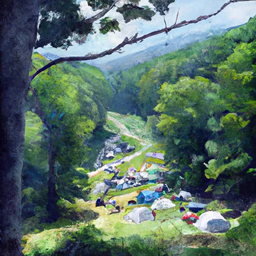
Lewis Mountain campground
Community Reviews
Been here? Share the conditions.
Reviews, ratings & photos are added in the free Snoflo iOS app — rate a spot, tag the conditions, and your visit is verified by location. Add or manage your reviews from the app.
Lewis Mountain
One of the main attractions near Lewis Mountain is the Dark Hollow Falls trail, which is a 1.4-mile hike to a 70-foot waterfall. Another nearby trail is the Lewis Falls Trail, which is a 3.3-mile hike to a waterfall and offers stunning views of the surrounding mountains.
The campground at Lewis Mountain offers amenities such as restrooms, showers, a camp store, and fire pits. The area is also known for its stargazing opportunities due to its location away from major cities.
Interesting facts about the area include its history as a summer retreat for wealthy families in the early 20th century. The park was established in 1935 and covers over 200,000 acres.
The best time of year to visit Lewis Mountain is from late spring to early fall, with average temperatures ranging from the mid-60s to mid-80s. However, it is important to note that the area can be prone to afternoon thunderstorms during the summer months.
Overall, Lewis Mountain in Shenandoah National Park is a beautiful and peaceful camping area that offers stunning views, nearby attractions, and comfortable amenities for visitors to enjoy.
What's on-site at Lewis Mountain
Key facilities Snoflo tracks for this campground. Confirm with the operator before booking -- amenities can change seasonally.
Plan your trip down to the hour
Same weather feed Snoflo's iOS app uses -- updated continuously from NOAA / yr.no.
Next 5 days, hour by hour
Temperature line with weather symbols on top, snow + rain accumulation as columns, humidity as a dotted line.
5-day forecast table
Every 3 hours, broken out across temperature, snow, rain, humidity, and wind. Each cell is colour-coded relative to the column min/max so trends jump out at a glance.
| Time | Condition | Temp (°F) | Snow (in) | Rain (in) | Humidity (%) | Wind (mps) | Wind dir |
|---|---|---|---|---|---|---|---|
| Loading detailed forecast… | |||||||
15-day temperature & precipitation
Daily temperatures, snow, and rain projected over the next two weeks. Hover any point for the full breakdown.
Other campgrounds in the area
Snoflo-tracked campsites within driving distance of Lewis Mountain, with reservations status.
| Campground | Reservations | Toilets | View |
|---|---|---|---|
| Lewis Mountain Campground | ✗ | ✗ | → |
| Lewis Mountain - Shenandoah National Park | ✗ | ✗ | → |
| Big Meadows - Shenandoah National Park | ✓ | ✗ | → |
| Camp 6 | ✗ | ✗ | → |
| Boone Shelter | ✗ | ✗ | → |
Nearby streamflow
USGS streamgauges within reach of Lewis Mountain -- pulled live from the National Water Information System.
| Streamgauge | Discharge | View |
|---|---|---|
| Rapidan River Near Ruckersville | 34 cfs | → |
| S F Shenandoah River Near Luray | 609 cfs | → |
| S F Shenandoah River Near Lynnwood | 393 cfs | → |
| N F Rivanna River Near Earlysville | 10 cfs | → |
| Smith Creek Near New Market | 26 cfs | → |
| Moormans River Near Free Union | 3 cfs | → |
Nearby snow depths
NRCS SNOTEL stations within reach of Lewis Mountain -- relevant when planning a shoulder-season or alpine trip.
| SNOTEL station | Snowpack | 24h Snowfall | View |
|---|---|---|---|
| Dale Enterprise Coop | 0.0 in | 0.0 in | → |
| Charlottesville 2w Coop | 0.0 in | 0.0 in | → |
Plan a longer trip
The closest parks, lakes, boat launches, and paddle runs so a camping night can grow into a full weekend.
Parks
- Shenandoah Historic District
- Preddy Creek Trails Park
- Deep Run Ponds Natural Area Preserve
- Purcell Park
- James Madison's Montpelier
- Ivy Creek Natural Area
Boat launches
- Shenandoah Riverside
- Elkton
- Grove Hill River Road Page County
- Us 340 Business Page County
- Newport
- White House
Fishing spots
- Bealers Ferry Boat Launch
- Bealers Ferry Pond Accessible Fishing Site
- Moody Boat Launch
- Batzell Boat Launch
- Tomahawk Pond Day Use Area
- White Sulphur Pond
Points of interest
Paddle runs
- Bixler Bridge On State Route 675 To Karo Landing, Approximately 6 Miles South Of Town Of Front Royal
- Segment B--State Route 730 Bridge To Nf Boundary
- Segment C--Nf Boundary To Confluence With North Fork Shenandoah River
- North River Campground To Camp May Flather
- State Route 675 At Edinburg, Va To State Highway 55 Southeast Of Strasburg, Va
- Headwaters Adjacent To Fdt 573 To State Route 622 Bridge
Camping essentials & Leave No Trace
- Pack it in, pack it out
- Take all trash, food scraps, and gear back with you to keep campsites clean and protect wildlife.
- Respect wildlife
- Observe animals from a distance, store food securely, and never feed wildlife to maintain natural behavior and safety.
- Know before you go
- Check weather, fire restrictions, trail conditions, and permit requirements to ensure a safe and well-planned trip.
- Minimize campfire impact
- Use established fire rings, keep fires small, fully extinguish them, or opt for a camp stove when fires are restricted.
- Leave what you find
- Preserve natural and cultural features by avoiding removal of plants, rocks, artifacts, or other elements of the environment.
Set push alerts in the Snoflo app
Save Lewis Mountain as a favorite, set a custom threshold (precipitation, snowpack, freezing temperatures), and the iOS app will push the moment conditions cross.
About Lewis Mountain
Can I make reservations at Lewis Mountain?
This campground does not appear to accept reservations -- it's typically first-come, first-served. Arrive early on summer weekends.
How fresh is the weather data on this page?
The hourly forecast updates throughout the day from the NOAA / yr.no public feeds. Streamflow data is pulled live from USGS streamgauges and snowpack from the NRCS SNOTEL network.
What's the best time of year to visit?
Use the 15-day temperature & precipitation outlook on this page to plan -- pick a window with comfortable temperatures and low precipitation. For longer trips, the 5-day hourly meteogram shows snow + rain accumulation hour-by-hour.
How do I get to Lewis Mountain?
Tap Directions in the hero above to open driving directions in Google Maps, or Open in map to center the Snoflo interactive map on the campground.
Can I get alerts when conditions change?
Yes -- alerts are managed through the Snoflo iOS app. Favorite this campground, set a threshold (temperature, snowpack, precipitation), and you'll get a push the moment it crosses.
Other campgrounds near here
Snoflo-tracked campgrounds within driving distance of Lewis Mountain.