Moquah

Climate Recreation Community Catastrophe

Moquah
Eden Index

Climate 5.7 Recreation 2.9 Community 2.7 Safeguard

4.0/10

Moquah is a small town located in Bayfield County, Wisconsin. The climate in Moquah is classified as humid continental, characterized by cold winters and warm summers. Average temperatures range from around 10°F (-12°C) in winter to 80°F (27°C) in summer. Precipitation is abundant throughout the year, with an average annual rainfall of around 30 inches.

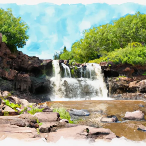
Hydrologically, Moquah is situated near the Moquah River, a tributary of Lake Superior. The river provides opportunities for fishing, particularly for trout, as well as canoeing and kayaking. The area also boasts numerous lakes and ponds, offering additional recreational options for boating, swimming, and water sports.

Outdoor enthusiasts will find Moquah to be an ideal destination for various activities. The nearby Chequamegon-Nicolet National Forest provides ample opportunities for hiking, camping, and wildlife observation. The area is renowned for its fall foliage, making it a popular destination for leaf-peeping and photography. In winter, snowmobiling, cross-country skiing, and snowshoeing are popular activities in the area.

With its diverse climate, hydrology constituents, and abundant outdoor recreation opportunities, Moquah is an enticing destination for nature lovers and adventure seekers alike.

What is the Eden Index?

The Snoflo Eden Index serves as a comprehensive rating system for regions, evaluating their desirability through a holistic assessment of climate health, outdoor recreation opportunities, and natural disaster risk, acknowledging the profound impact of these factors on livability and well-being.


Climate Health Indicator (CHI): 5.7


Moquah receives approximately 752mm of rain per year, with humidity levels near 83% and air temperatures averaging around 6°C. Moquah has a plant hardyness factor of 4, meaning plants and agriculture in this region thrive during a short period during spring and early summer. Most plants will die off during the colder winter months. By considering the ideal temperature range, reliable water supplies, clean air, and stable seasonal rain or snowpacks, the Climate Health Indicator (CHI) underscores the significance of a healthy climate as the foundation for quality living.

A healthy climate is paramount for ensuring a high quality of life and livability in a region, fostering both physical well-being and environmental harmony. This can be characterized by ideal temperatures, reliable access to water supplies, clean air, and consistent seasonal rain or snowpacks.


Weather Forecast


Streamflow Conditions

Southwestern Lake Superior

Area Rivers

Southwestern Lake Superior


Snowpack Depths

Southwestern Lake Superior


Reservoir Storage Capacity

Southwestern Lake Superior


Groundwater Levels


Recreational Opportunity Index (ROI): 2.9


The Recreational Opportunity Index (ROI) recognizes the value of outdoor recreational options, such as parks, hiking trails, camping sites, and fishing spots, while acknowledging that climate plays a pivotal role in ensuring the comfort and consistency of these experiences. Access to outdoor recreational opportunities, encompassing activities such as parks, hiking, camping, and fishing, is crucial for overall well-being, and the climate plays a pivotal role in enabling and enhancing these experiences, ensuring that individuals can engage in nature-based activities comfortably and consistently.


Camping Areas

Campground Campsites Reservations Toilets Showers Elevation
Watercress 114 523 ft
Wild Rock County Park 30 1,067 ft
Sugar Creek City Campground None 618 ft
Leroy Percy State Park None 108 ft
Cuivre River State Park 94 658 ft
Fourth Pumping Plant Rec Area 22 531 ft
Deer Leap 46 338 ft
River Road - Clearwater Lake None 471 ft
Memorial Park - Washburn 51 636 ft
Sawbill Lake 50 1,863 ft
Meramec State Park None 613 ft
Henderson County State Conservation 35 554 ft
Beauford T. Anderson Park None 723 ft
Robertsville State Park 27 502 ft
Great River Road State Park None 150 ft
Toohey Lake 10 1,674 ft
Council Bluff - Wild Boar Ridge 100 1,268 ft
Mead Lake Park 71 1,109 ft
Stock Farm Bridge 8 1,463 ft
Lake Three 8 1,384 ft
Eden Valley Park None 710 ft
West End Thompson City Park 51 602 ft
Snively Access 30 656 ft
Float Camp 16 472 ft
Pine View Military - Fort McCoy None 870 ft
Ridge - Sidie Hollow Park 20 1,209 ft
Lake Charlie Capps None 146 ft
Crescent Lake 34 1,819 ft
Castle Mound - Black River State Forest 35 855 ft
Big River State Forest 100 541 ft
Fillmore County Rec Area None 835 ft
Highway K - Clearwater Lake None 600 ft
Rock Dam Park 150 1,014 ft
Bennett Park 13 795 ft
Russell Memorial Park 230 955 ft
Johnsons Shut-Ins State Park None 849 ft
Washington State Park None 637 ft
Day Lake 52 1,511 ft
Coon Fork Lake None 990 ft
Robb City Park None 700 ft
Connors Lake - Flambeau River State Forest 30 1,457 ft
Main - Sidie Hollow Park 31 930 ft
Argyle Lake State Park 160 695 ft
Joinerville County Park None 684 ft
Keithsburg Riverside Campground 60 541 ft
Baker Lake 5 1,827 ft
Big Spring - Ozark National Scenic River 123 727 ft
Bankston Park 50 950 ft
Josie Creek County Park 15 1,250 ft
Blanchard Island - Mississippi River 35 556 ft
Black Lake 29 1,426 ft
Walnut Grove Co Park None 691 ft
Babler Memorial State Park None 733 ft
Finleys Landing City Park 30 633 ft
Shady Creek - Mississippi River 50 554 ft
Lake of the Pines - Flambeau River State Forest 30 1,493 ft
Maquoketa Caves State Park None 888 ft
North Rec Composite 15 97 ft
George Crosby - Manitou State Park 20 1,431 ft
Siloam Springs State Park 180 690 ft
East Twin 10 1,502 ft
Wildcat Mound County Park None 1,112 ft
Klondike County Park None 530 ft
Hawkins Community Park None 1,374 ft
Clarks Ferry - Mississippi River 45 556 ft
Kawishiwi Lake 5 1,660 ft
West Arbutus County Park 44 938 ft
Esofea - Rentz Memorial Park 27 958 ft
Delabar State Park 60 575 ft
Prentice City Park None 599 ft
Temperance River 11 1,524 ft
Sutton Bluff 45 820 ft
Ninemile Lake 24 1,644 ft
Pittsfield City Lake None 639 ft
Kreher City Park 33 604 ft
Berryman 19 1,009 ft
Pictured Rocks Co Park None 885 ft
Fairport State Rec Area 40 566 ft
East Arbutus Camp 187 891 ft
Weinberg - King State Park 19 590 ft
Anderson Campground - Soldiers Grove 30 725 ft
Swiss Valley County Park 100 726 ft
Cappy Russell Access Dispersed None 554 ft
Boat Landing - Sidie Hollow Park 22 939 ft
Great River Road Campground None 451 ft
Mud Lake County Park 75 638 ft
Hixton Village Campground 20 943 ft
Namekagon 34 1,453 ft
Gile Memorial Village 20 932 ft
South Recreation Composite 100 140 ft
Ferry Landing 50 604 ft
Sherman Co Park None 701 ft
Webb Creek - Clearwater Lake None 727 ft
Bluff View - Clearwater Lake None 572 ft
Hazel Creek None 846 ft
Mineral Lake 12 1,442 ft
Snyder Park 32 1,010 ft
Piedmont - Clearwater Lake None 570 ft

Catastrophe Safeguard Index (CSI):


The Catastrophe Safeguard Index (CSI) recognizes that natural disaster risk, encompassing floods, fires, hurricanes, and tornadoes, can drastically affect safety and the overall appeal of an area. The level of natural disaster risk in a region significantly affects safety and the overall livability, with climate change amplifying these risks by potentially increasing the frequency and intensity of events like floods, fires, hurricanes, and tornadoes, thereby posing substantial challenges to community resilience and well-being.


Community Resilience Indicator (CRI): 2.7


The Community Resilience Indicator (CRI) recognizes that education, healthcare, and socioeconomics are crucial to the well-being of a region. The CRI acknowledges the profound impact of these elements on residents' overall quality of life. By evaluating educational resources, healthcare accessibility, and economic inclusivity, the index captures the essential aspects that contribute to a thriving community, fostering resident satisfaction, equity, and social cohesion.


Log Your Visit

When was your last visit to ?

Add a Photo

How was it? How were conditions?

Rate the


Submit

Leave A Review


Submit

Upload an Image


Favorite Limit Reached