Northboro

Climate Recreation Community Catastrophe

Northboro
Eden Index

Climate 8.1 Recreation 2.5 Community Safeguard

4.1/10

Northboro, Iowa experiences a humid continental climate with four distinct seasons. Summers are warm and humid, with average temperatures reaching the high 80s°F. Winters are cold and snowy, with average temperatures in the 20s°F. The area receives around 33 inches of precipitation annually, evenly distributed throughout the year.

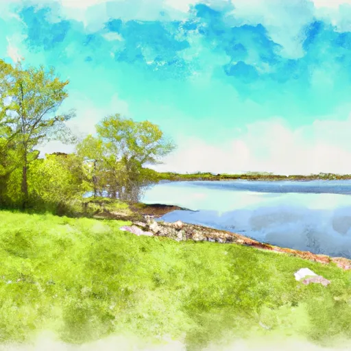
Northboro is surrounded by beautiful natural surroundings, including several lakes and rivers. The East Nishnabotna River flows through the region, providing opportunities for fishing and boating. Outdoor enthusiasts can also explore the nearby Waubonsie State Park, offering hiking trails, camping facilities, and picturesque views. With its diverse landscape and natural beauty, Northboro offers a range of outdoor recreation opportunities for residents and visitors alike.

What is the Eden Index?

The Snoflo Eden Index serves as a comprehensive rating system for regions, evaluating their desirability through a holistic assessment of climate health, outdoor recreation opportunities, and natural disaster risk, acknowledging the profound impact of these factors on livability and well-being.


Climate Health Indicator (CHI): 8.1


Northboro receives approximately 870mm of rain per year, with humidity levels near 83% and air temperatures averaging around 11°C. Northboro has a plant hardyness factor of 5, meaning plants and agriculture in this region thrive during a short period during spring and early summer. Most plants will die off during the colder winter months. By considering the ideal temperature range, reliable water supplies, clean air, and stable seasonal rain or snowpacks, the Climate Health Indicator (CHI) underscores the significance of a healthy climate as the foundation for quality living.

A healthy climate is paramount for ensuring a high quality of life and livability in a region, fostering both physical well-being and environmental harmony. This can be characterized by ideal temperatures, reliable access to water supplies, clean air, and consistent seasonal rain or snowpacks.


Weather Forecast


Streamflow Conditions

Missouri-Nishnabotna

Area Rivers

Missouri-Nishnabotna


Snowpack Depths

Missouri-Nishnabotna


Reservoir Storage Capacity

Missouri-Nishnabotna


Groundwater Levels


Recreational Opportunity Index (ROI): 2.5


The Recreational Opportunity Index (ROI) recognizes the value of outdoor recreational options, such as parks, hiking trails, camping sites, and fishing spots, while acknowledging that climate plays a pivotal role in ensuring the comfort and consistency of these experiences. Access to outdoor recreational opportunities, encompassing activities such as parks, hiking, camping, and fishing, is crucial for overall well-being, and the climate plays a pivotal role in enabling and enhancing these experiences, ensuring that individuals can engage in nature-based activities comfortably and consistently.


Camping Areas

Campground Campsites Reservations Toilets Showers Elevation
Pomona State Park 370 1,023 ft
Carson City Park 15 1,060 ft
Pottawattamie County Fairgrounds 60 1,132 ft
Pioneer City Park None 1,080 ft
Lake Garnett City Park None 1,035 ft
Prairie Rose State Park 95 1,250 ft
Legion City Park 10 1,033 ft
Olde Towne Co Park None 1,044 ft
Nishna Bend Rec Area 14 1,188 ft
Michigan Valley - Pomona Reservoir 95 998 ft
Lyons Park None 1,214 ft
Botna Bend County Park 40 1,108 ft
Pierce Creek Rec Area 20 1,078 ft
Outlet Park - Pomona Reservoir 35 980 ft

Catastrophe Safeguard Index (CSI):


The Catastrophe Safeguard Index (CSI) recognizes that natural disaster risk, encompassing floods, fires, hurricanes, and tornadoes, can drastically affect safety and the overall appeal of an area. The level of natural disaster risk in a region significantly affects safety and the overall livability, with climate change amplifying these risks by potentially increasing the frequency and intensity of events like floods, fires, hurricanes, and tornadoes, thereby posing substantial challenges to community resilience and well-being.


Community Resilience Indicator (CRI):


The Community Resilience Indicator (CRI) recognizes that education, healthcare, and socioeconomics are crucial to the well-being of a region. The CRI acknowledges the profound impact of these elements on residents' overall quality of life. By evaluating educational resources, healthcare accessibility, and economic inclusivity, the index captures the essential aspects that contribute to a thriving community, fostering resident satisfaction, equity, and social cohesion.


Log Your Visit

When was your last visit to ?

Add a Photo

How was it? How were conditions?

Rate the


Submit

Leave A Review


Submit

Upload an Image


Favorite Limit Reached