Ringgold

Climate Recreation Community Catastrophe

Ringgold
Eden Index

Climate 7.7 Recreation 2.5 Community Safeguard

4.0/10

Ringgold is a small town located in Bienville Parish, Louisiana. The climate in Ringgold is categorized as humid subtropical, characterized by hot and humid summers and mild winters. Average temperatures range from the upper 80s Fahrenheit (around 31°C) in summer to the mid-50s Fahrenheit (around 13°C) in winter. Rainfall is evenly distributed throughout the year, with the wettest months being May and October.

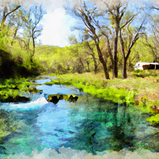
Ringgold is surrounded by beautiful natural landscapes, including lakes, rivers, and forests. Hydrologically, it is situated near several bodies of water, such as Lake Bistineau, which offers opportunities for fishing, boating, and water sports. The lake is known for its diverse fish species and is a popular spot for anglers. Additionally, nearby Kisatchie National Forest provides opportunities for hiking, camping, and wildlife viewing.

Outdoor enthusiasts in Ringgold can also explore the Dorcheat Bayou, a scenic waterway that offers kayaking and canoeing opportunities. The bayou is home to various wildlife species, including alligators, turtles, and numerous bird species. Overall, Ringgold provides a favorable climate, diverse hydrology constituents, and ample outdoor recreation opportunities for nature lovers.

What is the Eden Index?

The Snoflo Eden Index serves as a comprehensive rating system for regions, evaluating their desirability through a holistic assessment of climate health, outdoor recreation opportunities, and natural disaster risk, acknowledging the profound impact of these factors on livability and well-being.


Climate Health Indicator (CHI): 7.7


Ringgold receives approximately 1361mm of rain per year, with humidity levels near 87% and air temperatures averaging around 18°C. Ringgold has a plant hardyness factor of 8, meaning plants and agriculture in this region tend to thrive here all year round. By considering the ideal temperature range, reliable water supplies, clean air, and stable seasonal rain or snowpacks, the Climate Health Indicator (CHI) underscores the significance of a healthy climate as the foundation for quality living.

A healthy climate is paramount for ensuring a high quality of life and livability in a region, fostering both physical well-being and environmental harmony. This can be characterized by ideal temperatures, reliable access to water supplies, clean air, and consistent seasonal rain or snowpacks.


Weather Forecast


Streamflow Conditions


Area Rivers


Snowpack Depths


Reservoir Storage Capacity


Groundwater Levels


Recreational Opportunity Index (ROI): 2.5


The Recreational Opportunity Index (ROI) recognizes the value of outdoor recreational options, such as parks, hiking trails, camping sites, and fishing spots, while acknowledging that climate plays a pivotal role in ensuring the comfort and consistency of these experiences. Access to outdoor recreational opportunities, encompassing activities such as parks, hiking, camping, and fishing, is crucial for overall well-being, and the climate plays a pivotal role in enabling and enhancing these experiences, ensuring that individuals can engage in nature-based activities comfortably and consistently.


Camping Areas

Campground Campsites Reservations Toilets Showers Elevation
Holbrook Parish Park None 20 ft
Hodges Gardens State Park 30 320 ft
Lotus Camp 20 215 ft
Spring Lake 53 522 ft
Intracoastal Parish Park 25 8 ft
White Oak Lake State Park None 208 ft
Alpine Ridge - De Gray Lake 49 473 ft
Shoal Bay - Lake Dardanelle None 375 ft
South Abutment East 12 177 ft
Twin Creek - Lake Ouachita 15 590 ft
Lake Ouachita State Park None 759 ft
Frank Anthony RV Park 30 242 ft
Big Fir 50 617 ft
Ivan Lake 4 212 ft
Lena Landing - Lake Ouachita 10 599 ft
Shouse Ford - De Gray Lake 99 401 ft
Tompkins Bend - Lake Ouachita 77 603 ft
DeGray Lake State Park 113 403 ft
Long Pool 77 615 ft
Brady Mountain - Lake Ouachita 74 616 ft
Highway 27 - Lake Ouachita None 593 ft
County Line None 359 ft
Edgewood - De Gray Lake 51 409 ft
Dogwood Complex 12 174 ft
Haw Creek Falls 9 791 ft
Cane Creek - Lake Dardanelle 16 344 ft
Crystal Springs - Lake Ouachita 74 623 ft
Stephens - Lake Ouachita 9 420 ft
Cedar Fourche - Lake Ouachita None 587 ft
Logoly State Park None 327 ft
Irons Fork - Lake Ouachita 12 586 ft
Riverview - Lake Dardanelle None 363 ft
Lost Valley - Buffalo National River None 1,096 ft
Denby Point - Lake Ouachita 67 655 ft
Sam Houston Jones State Park 40 18 ft
River Road None 355 ft
Quarry Cove None 372 ft
Red Bluff Camp Complex 10 205 ft
Carter Cove None 358 ft
Spadra - Lake Dardanelle None 360 ft
Highway 157 Primitive None 203 ft
Joplin - Lake Ouachita 64 592 ft
Steel Creek - Buffalo National River None 977 ft
Charlton 58 725 ft
Ozone 28 1,825 ft
Lake Dardanelle State Park None 344 ft
Ozan Point - De Gray Lake 50 422 ft
Turtle Slide None 223 ft
Little Fir - Lake Ouachita 29 602 ft
Buckville - Lake Ouachita None 610 ft
Caddo Drive - De Gray Lake 72 415 ft
Piney Bay - Lake Dardanelle None 365 ft
Avant - Lake Ouachita 25 589 ft
Lake Bistineau State Park None 170 ft
Iron Mountain - De Gray Lake 69 456 ft
Teague Lake Primitive None 199 ft
Rabbit Tail - Lake Ouachita None 652 ft
Mount Nebo State Park None 1,404 ft
Point Cedar - De Gray Lake 62 417 ft
Arlie Moore - De Gray Lake 87 517 ft
Washita - Lake Ouachita None 600 ft

Catastrophe Safeguard Index (CSI):


The Catastrophe Safeguard Index (CSI) recognizes that natural disaster risk, encompassing floods, fires, hurricanes, and tornadoes, can drastically affect safety and the overall appeal of an area. The level of natural disaster risk in a region significantly affects safety and the overall livability, with climate change amplifying these risks by potentially increasing the frequency and intensity of events like floods, fires, hurricanes, and tornadoes, thereby posing substantial challenges to community resilience and well-being.


Community Resilience Indicator (CRI):


The Community Resilience Indicator (CRI) recognizes that education, healthcare, and socioeconomics are crucial to the well-being of a region. The CRI acknowledges the profound impact of these elements on residents' overall quality of life. By evaluating educational resources, healthcare accessibility, and economic inclusivity, the index captures the essential aspects that contribute to a thriving community, fostering resident satisfaction, equity, and social cohesion.


Log Your Visit

When was your last visit to ?

Add a Photo

How was it? How were conditions?

Rate the


Submit

Leave A Review


Submit

Upload an Image


Favorite Limit Reached