Tazewell

Climate Recreation Community Catastrophe

Tazewell
Eden Index

Climate 8.2 Recreation 2.2 Community 2.3 Safeguard

4.6/10

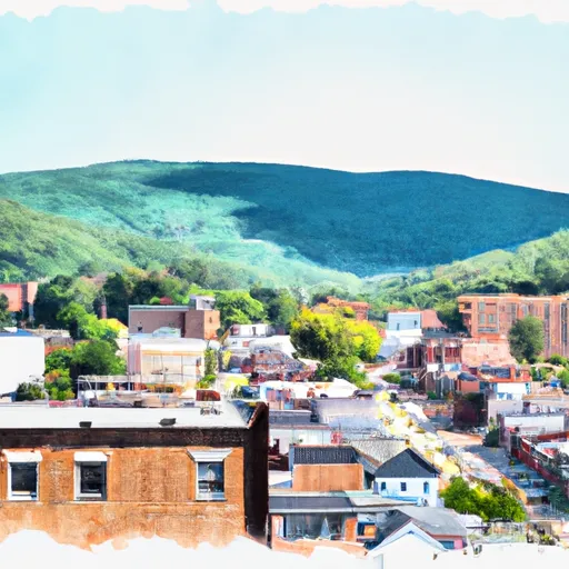
Tazewell, Virginia is a charming town nestled in the Appalachian Mountains. With a humid subtropical climate, residents and visitors can expect hot, humid summers and mild to cool winters. Average temperatures range from 27°F (-3°C) in January to 86°F (30°C) in July. The region experiences precipitation throughout the year, with an average annual rainfall of 42 inches (1,066 mm) and occasional snowfall during the winter months.

Tazewell benefits from the presence of the Clinch River, which flows through the area. The river serves as a vital hydrological feature, providing a scenic backdrop and offering various recreational opportunities such as fishing, kayaking, and canoeing. Anglers can find a diverse array of fish species, including smallmouth bass and channel catfish.

In addition to the Clinch River, Tazewell boasts numerous outdoor recreation opportunities. The nearby Appalachian Trail provides hiking enthusiasts with breathtaking vistas and challenging trails, while the Jefferson National Forest offers countless options for camping, hunting, and wildlife viewing. Tazewell County also features several parks and recreational areas, providing opportunities for picnicking, boating, and swimming in the warmer months.

Overall, Tazewell, Virginia offers a temperate climate, a scenic hydrological landscape, and diverse outdoor recreational activities, making it an ideal destination for nature lovers and adventure seekers.

What is the Eden Index?

The Snoflo Eden Index serves as a comprehensive rating system for regions, evaluating their desirability through a holistic assessment of climate health, outdoor recreation opportunities, and natural disaster risk, acknowledging the profound impact of these factors on livability and well-being.


Climate Health Indicator (CHI): 8.2


Tazewell receives approximately 1168mm of rain per year, with humidity levels near 85% and air temperatures averaging around 11°C. Tazewell has a plant hardyness factor of 6, meaning plants and agriculture in this region thrive during a short period during spring and early summer. Most plants will die off during the colder winter months. By considering the ideal temperature range, reliable water supplies, clean air, and stable seasonal rain or snowpacks, the Climate Health Indicator (CHI) underscores the significance of a healthy climate as the foundation for quality living.

A healthy climate is paramount for ensuring a high quality of life and livability in a region, fostering both physical well-being and environmental harmony. This can be characterized by ideal temperatures, reliable access to water supplies, clean air, and consistent seasonal rain or snowpacks.


Weather Forecast


Streamflow Conditions

Upper Tennessee

Area Rivers

Upper Tennessee


Snowpack Depths

Upper Tennessee


Reservoir Storage Capacity

Upper Tennessee


Groundwater Levels


Recreational Opportunity Index (ROI): 2.2


The Recreational Opportunity Index (ROI) recognizes the value of outdoor recreational options, such as parks, hiking trails, camping sites, and fishing spots, while acknowledging that climate plays a pivotal role in ensuring the comfort and consistency of these experiences. Access to outdoor recreational opportunities, encompassing activities such as parks, hiking, camping, and fishing, is crucial for overall well-being, and the climate plays a pivotal role in enabling and enhancing these experiences, ensuring that individuals can engage in nature-based activities comfortably and consistently.


Catastrophe Safeguard Index (CSI):


The Catastrophe Safeguard Index (CSI) recognizes that natural disaster risk, encompassing floods, fires, hurricanes, and tornadoes, can drastically affect safety and the overall appeal of an area. The level of natural disaster risk in a region significantly affects safety and the overall livability, with climate change amplifying these risks by potentially increasing the frequency and intensity of events like floods, fires, hurricanes, and tornadoes, thereby posing substantial challenges to community resilience and well-being.


Community Resilience Indicator (CRI): 2.3


The Community Resilience Indicator (CRI) recognizes that education, healthcare, and socioeconomics are crucial to the well-being of a region. The CRI acknowledges the profound impact of these elements on residents' overall quality of life. By evaluating educational resources, healthcare accessibility, and economic inclusivity, the index captures the essential aspects that contribute to a thriving community, fostering resident satisfaction, equity, and social cohesion.


Log Your Visit

When was your last visit to ?

Add a Photo

How was it? How were conditions?

Rate the


Submit

Leave A Review


Submit

Upload an Image


Favorite Limit Reached