-
Snoflo Premium
Get unlimited access to all our content
With no Ad interruptions! - Start Your Free Trial Login with existing account
Whitetop
Eden Index
Climate
7.4
•
Recreation
6.9
•
Community
•
Safeguard
5.4/10
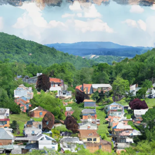
Whitetop, Virginia is a picturesque mountain community located in the southwestern part of the state. Nestled in the heart of the Mount Rogers National Recreation Area, it offers a unique climate and a wealth of outdoor recreation opportunities.
The climate in Whitetop can be described as cool and temperate, with mild summers and cold winters. The area experiences ample rainfall throughout the year, contributing to the hydrology constituents of the region. Whitetop is home to several streams and rivers, including the South Fork of the Holston River and Whitetop Laurel Creek, which provide abundant fishing and kayaking opportunities.
Outdoor enthusiasts will find a wide range of activities to enjoy in Whitetop. The area boasts an extensive network of hiking and biking trails, offering stunning panoramic views of the surrounding mountains. One of the highlights is the Virginia Creeper Trail, a popular 34.3-mile multi-use trail that winds through the scenic countryside, making it perfect for biking, walking, or horseback riding.
Additionally, Whitetop is known for its excellent camping facilities, providing the perfect setting for overnight stays and outdoor adventures. Whether it's fishing, hiking, biking, or simply immersing in the natural beauty, Whitetop offers a remarkable outdoor experience for visitors and residents alike.
What is the Eden Index?
The Snoflo Eden Index serves as a comprehensive rating system for regions, evaluating their desirability through a holistic assessment of climate health, outdoor recreation opportunities, and natural disaster risk, acknowledging the profound impact of these factors on livability and well-being.
Climate Health Indicator (CHI): 7.4
Whitetop receives approximately
1328mm of rain per year,
with humidity levels near 83%
and air temperatures averaging around
10°C.
Whitetop has a plant hardyness factor of
6, meaning
plants and agriculture in this region thrive during a short period during spring and early summer. Most
plants will die off during the colder winter months.
By considering the ideal temperature range, reliable water supplies, clean air, and stable seasonal rain or snowpacks, the Climate Health Indicator (CHI) underscores the significance of a healthy climate as the foundation for quality living.
A healthy climate is paramount for ensuring a high quality of life and livability in a region, fostering both physical well-being and environmental harmony. This can be characterized by ideal temperatures, reliable access to water supplies, clean air, and consistent seasonal rain or snowpacks.
Weather Forecast
Streamflow Conditions
Area Rivers
Snowpack Depths
Reservoir Storage Capacity
Groundwater Levels
Recreational Opportunity Index (ROI): 6.9
The Recreational Opportunity Index (ROI) recognizes the value of outdoor recreational options, such as parks, hiking trails, camping sites, and fishing spots, while acknowledging that climate plays a pivotal role in ensuring the comfort and consistency of these experiences.
Access to outdoor recreational opportunities, encompassing activities such as parks, hiking, camping, and fishing, is crucial for overall well-being, and the climate plays a pivotal role in enabling and enhancing these experiences, ensuring that individuals can engage in nature-based activities comfortably and consistently.
Camping Areas
Campground | Campsites | Reservations | Toilets | Showers | Elevation |
---|---|---|---|---|---|
John H. Moss Lake City Campground | None | 765 ft | |||
Hurricane | 30 | 2,908 ft | |||
Grindstone | 108 | 3,771 ft | |||
South Mountains State Park | None | 1,243 ft | |||
Beartree | 90 | 3,128 ft | |||
Julian Price - Blue Ridge Parkway | 40 | 3,521 ft | |||
Guyandotte | None | 1,233 ft | |||
Raccoon Branch | 20 | 2,823 ft | |||
Hungry Mother State Park | None | 2,196 ft | |||
Mortimer | 21 | 1,501 ft | |||
Grayson Highlands State Park | None | 4,310 ft |
Catastrophe Safeguard Index (CSI):
The Catastrophe Safeguard Index (CSI) recognizes that natural disaster risk, encompassing floods, fires, hurricanes, and tornadoes, can drastically affect safety and the overall appeal of an area.
The level of natural disaster risk in a region significantly affects safety and the overall livability, with climate change amplifying these risks by potentially increasing the frequency and intensity of events like floods, fires, hurricanes, and tornadoes, thereby posing substantial challenges to community resilience and well-being.
Community Resilience Indicator (CRI):
The Community Resilience Indicator (CRI) recognizes that education, healthcare, and socioeconomics are crucial to the well-being of a region. The CRI acknowledges the profound impact of these elements on residents' overall quality of life. By evaluating educational resources, healthcare accessibility, and economic inclusivity, the index captures the essential aspects that contribute to a thriving community, fostering resident satisfaction, equity, and social cohesion.