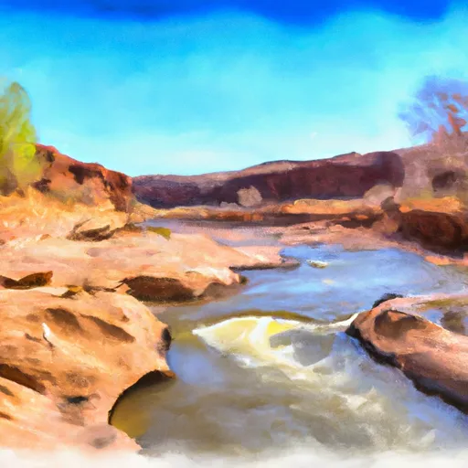
Paria River river run
Community Reviews
Been here? Share the conditions.
Reviews, ratings & photos are added in the free Snoflo iOS app — rate a spot, tag the conditions, and your visit is verified by location. Add or manage your reviews from the app.
Paria River
The Paria River features several notable rapids and obstacles, including the House Rock Rapid, located about 9 miles downstream from the launch point, which is a class III-IV rapid with a large boulder in the middle of the channel that creates a challenging obstacle for boaters. Another significant rapid is the Paria Riffle, located about 23 miles downstream, which is a class III rapid that requires precise maneuvering to avoid rocks and shallow areas.
There are specific regulations to the area that must be followed in order to protect the river and surrounding environment. These regulations include obtaining a permit to float the river, following Leave No Trace principles, and adhering to strict camping guidelines to prevent damage to the fragile desert ecosystem.
In conclusion, the Paria River in Arizona offers a thrilling and challenging whitewater experience with a range of rapids and obstacles to navigate. With a specific set of regulations in place, it is important for boaters to follow guidelines to ensure the preservation of this unique and beautiful river system.
Plan your run down to the hour
Same weather feed Snoflo's iOS app uses -- updated continuously from NOAA / yr.no. Watch the precipitation column on the meteogram; rain ahead of a run typically lifts flows 12-48 hours later depending on the basin.
Next 5 days, hour by hour
Temperature line with weather symbols on top, snow + rain accumulation as columns, humidity as a dotted line.
5-day forecast table
Every 3 hours, broken out across temperature, snow, rain, humidity, and wind. Each cell is colour-coded relative to the column min/max.
| Time | Condition | Temp (°F) | Snow (in) | Rain (in) | Humidity (%) | Wind (mps) | Wind dir |
|---|---|---|---|---|---|---|---|
| Loading detailed forecast… | |||||||
15-day temperature & precipitation
Daily temperatures, snow, and rain projected over the next two weeks -- the upstream story that drives next week's flows.
Regional streamflow levels
USGS streamgauges around Paria River -- useful for spotting upstream pulses and gauging which tributary is contributing what.
| Streamgauge | Discharge | View |
|---|---|---|
| Paria River At Lees Ferry | 3 cfs | → |
| Colorado River At Lees Ferry | 9,060 cfs | → |
| Paria River Near Kanab | 0 cfs | → |
| Little Colorado River Abv Mouth Nr Desert View | 215 cfs | → |
| Kanab Creek Near Kanab | 4 cfs | → |
| Moenkopi Wash At Moenkopi | · | → |
Plan a longer trip
The closest boat launches, other paddle runs, and campgrounds so a day on the water can grow into a full weekend.
Boat launches
- Stateline Launch Ramp Kane County
- Wahweap - 1
- Wahweap - 2
- Antelope Point Boat Launch Coconino County
- Antelope Point Marina Access Coconino County
Other river runs
- Park Boundary To Confluence With The Colorado River
- Grand Canyon
- Paria River Segment 68-69
- Lower Paria River
Whitewater safety
- Check the flow before you run
- Use the linked-gauge card and Regional Flow panel above. Class ratings change with flow -- a Class III at low water can become Class IV+ at high water.
- Know your skill ceiling
- Pick runs comfortably below your ceiling. Cold-water and big-water runs raise the consequences of any mistake.
- Wear the right gear
- Helmet, PFD, drysuit / wetsuit when water is below 60°F. Throw bag, knife, and whistle on your person, not in the boat.
- Scout, set safety, and run with a team
- Scout new rapids on foot, set safety with throw bags above the consequence pool, and run with at least one other competent paddler.
- Respect the river
- Strainers, undercuts, low-head dams, and wood can kill at any class rating. When in doubt, portage.
Set push alerts in the Snoflo app
Save Paria River as a favorite, set a discharge threshold (e.g. "alert me when flow hits 600 cfs"), and the iOS app pushes the moment the linked gauge crosses.
About Paria River
What's the optimal flow for Paria River?
The optimal flow depends on the section and the craft. Check the Run Details panel for the linked gauge and current status.
How fresh is the cfs reading on this page?
The linked USGS streamgauge reports continuously (every 15 minutes); Snoflo refreshes throughout the day. Hover the streamflow sparkline to read individual datapoints.
What's the whitewater class?
See the Run Details panel for the class rating Snoflo tracks for this run. Class ratings change with flow -- a Class III at low water can become Class IV in high water.
Where do I put in / take out?
Tap Directions in the hero above to open driving directions to the put-in. For shuttle planning, check the Nearby Boat Launches panel and the river run operator's site.
Can I get alerts when flows hit the optimal range?
Yes -- alerts are managed in the Snoflo iOS app. Favorite this run, set a discharge threshold, and you'll get a push the moment the gauge crosses.
Other runs near here
Snoflo-tracked paddle runs within driving distance of Paria River.