Yampa River Segment 1 river run
Community Reviews
Been here? Share the conditions.
Reviews, ratings & photos are added in the free Snoflo iOS app — rate a spot, tag the conditions, and your visit is verified by location. Add or manage your reviews from the app.
Yampa River Segment 1
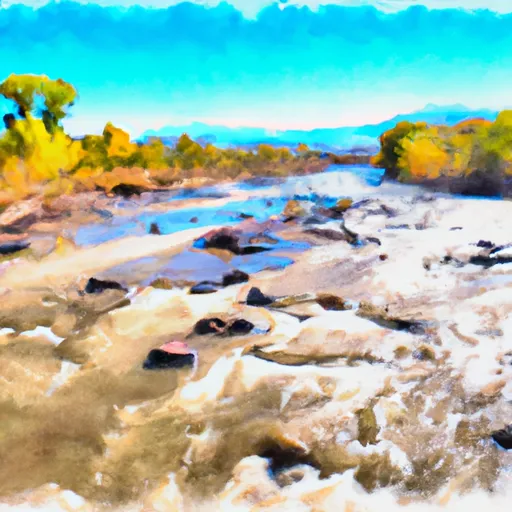
There are several notable rapids and obstacles on this section of the river, including the "Little Joe" rapid, which features a steep drop with a narrow channel and large boulders, as well as "Cable Rapid" and "Warm Springs Rapid," both of which require precise maneuvering around rocks and through narrow channels.
There are specific regulations in place for the Yampa River, including a permit system for commercial rafting companies and private boaters, as well as a ban on alcohol and glass containers. In addition, visitors are required to follow Leave No Trace principles to minimize their impact on the environment.
Overall, the Yampa River Segment 1 is a challenging and exciting whitewater run with unique rapids and stunning scenery. It is important to check current streamflow conditions and adhere to all regulations to ensure a safe and enjoyable experience.
Plan your run down to the hour
Same weather feed Snoflo's iOS app uses -- updated continuously from NOAA / yr.no. Watch the precipitation column on the meteogram; rain ahead of a run typically lifts flows 12-48 hours later depending on the basin.
Next 5 days, hour by hour
Temperature line with weather symbols on top, snow + rain accumulation as columns, humidity as a dotted line.
5-day forecast table
Every 3 hours, broken out across temperature, snow, rain, humidity, and wind. Each cell is colour-coded relative to the column min/max.
| Time | Condition | Temp (°F) | Snow (in) | Rain (in) | Humidity (%) | Wind (mps) | Wind dir |
|---|---|---|---|---|---|---|---|
| Loading detailed forecast… | |||||||
15-day temperature & precipitation
Daily temperatures, snow, and rain projected over the next two weeks -- the upstream story that drives next week's flows.
Regional streamflow levels
USGS streamgauges around Yampa River Segment 1 -- useful for spotting upstream pulses and gauging which tributary is contributing what.
| Streamgauge | Discharge | View |
|---|---|---|
| Yampa River Below Craig | 132 cfs | → |
| Elkhead Creek Near Craig | 38 cfs | → |
| Yampa River Near Maybell | 60 cfs | → |
| Yampa River Above Elkhead Creek Near Hayden | 95 cfs | → |
| Elkhead Creek Above Long Gulch | 0 cfs | → |
| White River Near Meeker | 198 cfs | → |
Plan a longer trip
The closest boat launches, other paddle runs, and campgrounds so a day on the water can grow into a full weekend.
Boat launches
- Moffat County
- West Duffy Mountain Boat Ramp
- Pebble Beach Boat Ramp
- Yampa River State Park
- Yampa River State Wildlife Area
Other river runs
- Yampa River Segment 2
- Pumphouse To Double Bridges
- Cross Mountain Gorge
- Yampa River Segment 3
- Flat Tops Wilderness Boundary To Nf Boundary
Campgrounds
- Duffy Mountain Camping
- Duffy Mountain Upper Vista Camping
- Duffy Mountain Axial Trailhead Camping
- West Duffy Mountain Camping
- Duffy Mountain - Yampa River State Park
- South Beach - Yampa River State Park
Whitewater safety
- Check the flow before you run
- Use the linked-gauge card and Regional Flow panel above. Class ratings change with flow -- a Class III at low water can become Class IV+ at high water.
- Know your skill ceiling
- Pick runs comfortably below your ceiling. Cold-water and big-water runs raise the consequences of any mistake.
- Wear the right gear
- Helmet, PFD, drysuit / wetsuit when water is below 60°F. Throw bag, knife, and whistle on your person, not in the boat.
- Scout, set safety, and run with a team
- Scout new rapids on foot, set safety with throw bags above the consequence pool, and run with at least one other competent paddler.
- Respect the river
- Strainers, undercuts, low-head dams, and wood can kill at any class rating. When in doubt, portage.
Set push alerts in the Snoflo app
Save Yampa River Segment 1 as a favorite, set a discharge threshold (e.g. "alert me when flow hits 600 cfs"), and the iOS app pushes the moment the linked gauge crosses.
About Yampa River Segment 1
What's the optimal flow for Yampa River Segment 1?
The optimal flow depends on the section and the craft. Check the Run Details panel for the linked gauge and current status.
How fresh is the cfs reading on this page?
The linked USGS streamgauge reports continuously (every 15 minutes); Snoflo refreshes throughout the day. Hover the streamflow sparkline to read individual datapoints.
What's the whitewater class?
See the Run Details panel for the class rating Snoflo tracks for this run. Class ratings change with flow -- a Class III at low water can become Class IV in high water.
Where do I put in / take out?
Tap Directions in the hero above to open driving directions to the put-in. For shuttle planning, check the Nearby Boat Launches panel and the river run operator's site.
Can I get alerts when flows hit the optimal range?
Yes -- alerts are managed in the Snoflo iOS app. Favorite this run, set a discharge threshold, and you'll get a push the moment the gauge crosses.
Other runs near here
Snoflo-tracked paddle runs within driving distance of Yampa River Segment 1.