Big Creek River Run
Community Reviews
Been here? Share the conditions.
Reviews, ratings & photos are added in the free Snoflo iOS app — rate a spot, tag the conditions, and your visit is verified by location. Add or manage your reviews from the app.
Big Creek
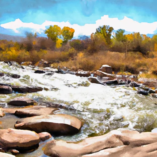
Big Creek is a popular whitewater river run located in the state of Colorado. The ideal streamflow range for this run is between 300 and 800 cubic feet per second (cfs), which is typically during the months of May and June. This run is rated as a Class IV-V, which is considered to be an advanced level of difficulty. The segment mileage for Big Creek is approximately 7 miles, making it a relatively short but intense run.
There are several specific rapids and obstacles on this stretch of river, including Boulder Garden, Top Drop, and S-Turns. Boulder Garden is a series of large boulders that require technical maneuvering to navigate. Top Drop is a steep, narrow chute that drops into a pool below. S-Turns are a series of tight turns that require precise boat control to avoid obstacles.
In terms of regulations, there are several important considerations for anyone planning to run Big Creek. First and foremost, it is important to obtain a permit from the US Forest Service before accessing the river. Additionally, there are restrictions on the use of motorized boats, and all boaters are required to wear a personal flotation device (PFD) at all times while on the water. It is also important to be aware of private property boundaries along the river, and to respect the rights of landowners in the area.
Overall, Big Creek is a challenging and exciting whitewater run that requires skill and experience to navigate safely. With the right conditions and careful preparation, it can be an unforgettable adventure for experienced boaters.
Plan your run down to the hour
Same weather feed Snoflo's iOS app uses -- updated continuously from NOAA / yr.no. Watch the precipitation column on the meteogram; rain ahead of a run typically lifts flows 12-48 hours later depending on the basin.
Next 5 days, hour by hour
Temperature line with weather symbols on top, snow + rain accumulation as columns, humidity as a dotted line.
5-day forecast table
Every 3 hours, broken out across temperature, snow, rain, humidity, and wind. Each cell is colour-coded relative to the column min/max.
| Time | Condition | Temp (°F) | Snow (in) | Rain (in) | Humidity (%) | Wind (mps) | Wind dir |
|---|---|---|---|---|---|---|---|
| Loading detailed forecast… | |||||||
15-day temperature & precipitation
Daily temperatures, snow, and rain projected over the next two weeks -- the upstream story that drives next week's flows.
Regional streamflow levels
USGS streamgauges around Big Creek -- useful for spotting upstream pulses and gauging which tributary is contributing what.
| Streamgauge | Discharge | View |
|---|---|---|
| North Platte River Near Northgate | 159 cfs | → |
| South Brush Creek Near Saratoga | 18 cfs | → |
| Encampment River Ab Hog Park Cr | 44 cfs | → |
| Encampment River At Mouth | 28 cfs | → |
| North Brush Creek Near Saratoga | 11 cfs | → |
| Laramie R Bl Pioneer Canal Nr Woods Landing | 1,010 cfs | → |
Plan a longer trip
The closest boat launches, other paddle runs, and campgrounds so a day on the water can grow into a full weekend.
Boat launches
Campgrounds
Fishing spots
- Big Creek Lakes Day Use Area
- Big Creek Lake(Lower)
- Big Creek Lake(Upper)
- Rob Roy Reservoir
- Hog Park Reservoir
- Cowdrey Lake
Whitewater safety
- Check the flow before you run
- Use the linked-gauge card and Regional Flow panel above. Class ratings change with flow -- a Class III at low water can become Class IV+ at high water.
- Know your skill ceiling
- Pick runs comfortably below your ceiling. Cold-water and big-water runs raise the consequences of any mistake.
- Wear the right gear
- Helmet, PFD, drysuit / wetsuit when water is below 60°F. Throw bag, knife, and whistle on your person, not in the boat.
- Scout, set safety, and run with a team
- Scout new rapids on foot, set safety with throw bags above the consequence pool, and run with at least one other competent paddler.
- Respect the river
- Strainers, undercuts, low-head dams, and wood can kill at any class rating. When in doubt, portage.
Set push alerts in the Snoflo app
Save Big Creek as a favorite, set a discharge threshold (e.g. "alert me when flow hits 600 cfs"), and the iOS app pushes the moment the linked gauge crosses.
About Big Creek
What's the optimal flow for Big Creek?
The optimal flow depends on the section and the craft. Check the Run Details panel for the linked gauge and current status.
How fresh is the cfs reading on this page?
The linked USGS streamgauge reports continuously (every 15 minutes); Snoflo refreshes throughout the day. Hover the streamflow sparkline to read individual datapoints.
What's the whitewater class?
See the Run Details panel for the class rating Snoflo tracks for this run. Class ratings change with flow -- a Class III at low water can become Class IV in high water.
Where do I put in / take out?
Tap Directions in the hero above to open driving directions to the put-in. For shuttle planning, check the Nearby Boat Launches panel and the river run operator's site.
Can I get alerts when flows hit the optimal range?
Yes -- alerts are managed in the Snoflo iOS app. Favorite this run, set a discharge threshold, and you'll get a push the moment the gauge crosses.
Other runs near here
Snoflo-tracked paddle runs within driving distance of Big Creek.