2026-02-19T12:00:00-06:00
* WHAT...Mixed precipitation. Additional snow accumulations up to 3 inches and ice accumulations around a light glaze. Winds gusting as high as 40 mph. * WHERE...Carlton and South St. Louis, Cook and Lake Counties. This includes the Tribal Lands of the Fond du Lac Band and the Grand Portage Reservation. This also includes the Boundary Waters eastern and central area. * WHEN...Until noon CST Thursday. * IMPACTS...Plan on slippery road conditions. The hazardous conditions could impact the Thursday morning commute.
Summary
The ideal streamflow range for this run is between 100-300 cfs. The class rating for this section of the river is Class II-III, with some Class IV rapids depending on water levels. The segment mileage for this run is approximately 15 miles.
There are several notable rapids and obstacles along the way, including the "Widowmaker" and "Big Nasty" rapids. Paddlers should also be aware of the numerous logjams and strainers that can be present in the river.
There are specific regulations for this area that paddlers should be aware of. The river is located within the Boundary Waters Canoe Area Wilderness, which means that permits are required for all overnight trips. Additionally, all gear must be packed out and campfires are only allowed in designated fire rings.
Overall, the Whitewater River Run offers a thrilling paddling experience for intermediate to advanced paddlers. It is important to check water levels and obtain the necessary permits before planning a trip to this area.
°F
°F
mph
Wind
%
Humidity
15-Day Weather Outlook
River Run Details
| Last Updated | 2026-02-07 |
| River Levels | 4410 cfs (3.84 ft) |
| Percent of Normal | 105% |
| Status | |
| Class Level | ii-iii |
| Elevation | ft |
| Streamflow Discharge | cfs |
| Gauge Height | ft |
| Reporting Streamgage | USGS 05443500 |


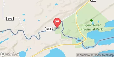
 North Fowl Lake
 South Fowl Lake
 Portage camp site
 McFarland Lake - Grand Portage State Forest
 Devilfish Lake - Grand Portage State Forest
 Pine Woods camp site
 South Fowl Lake In T64N, R3E To Lake Superior In T64N, R7E
 Western Boundary Of Grand Portage National Monument To Eastern Boundary Of Grand Portage National Monument
 Bwcaw Boundary To Forest Boundary In T62N, R2E