Confluence Of 2 Headwaters For South Fork (Sec 28, T10s, R11e) To Southern Boundary Of South Fork Campground River Run
Community Reviews
Been here? Share the conditions.
Reviews, ratings & photos are added in the free Snoflo iOS app — rate a spot, tag the conditions, and your visit is verified by location. Add or manage your reviews from the app.
Confluence Of 2 Headwaters For South Fork (Sec 28, T10s, R11e) To Southern Boundary Of South Fork Campground
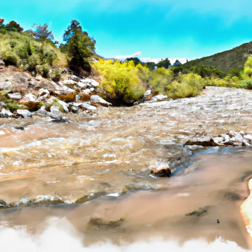
The segment runs for approximately 7.5 miles from the confluence of the two headwaters down to the southern boundary of the South Fork Campground. Along the way, there are numerous rapids and obstacles to navigate, including a Class III rapid called "Big Horn" and a Class II rapid called "Cottonwood Falls." The river also features some beautiful scenery, including red rock cliffs and ponderosa pine forests.
There are specific regulations in place for the area to ensure the safety of those participating in the whitewater river run. All boaters must wear personal flotation devices (PFDs) at all times, and it is recommended that they wear helmets as well. Additionally, all boats must be equipped with a whistle, and kayakers must have a spray skirt and a rescue throw bag.
Overall, the Whitewater River Run at the Confluence of 2 Headwaters for South Fork offers an exciting and challenging adventure for those looking to experience the thrill of whitewater rafting and kayaking in New Mexico.
Plan your run down to the hour
Same weather feed Snoflo's iOS app uses -- updated continuously from NOAA / yr.no. Watch the precipitation column on the meteogram; rain ahead of a run typically lifts flows 12-48 hours later depending on the basin.
Next 5 days, hour by hour
Temperature line with weather symbols on top, snow + rain accumulation as columns, humidity as a dotted line.
5-day forecast table
Every 3 hours, broken out across temperature, snow, rain, humidity, and wind. Each cell is colour-coded relative to the column min/max.
| Time | Condition | Temp (°F) | Snow (in) | Rain (in) | Humidity (%) | Wind (mps) | Wind dir |
|---|---|---|---|---|---|---|---|
| Loading detailed forecast… | |||||||
15-day temperature & precipitation
Daily temperatures, snow, and rain projected over the next two weeks -- the upstream story that drives next week's flows.
Regional streamflow levels
USGS streamgauges around Confluence Of 2 Headwaters For South Fork (Sec 28, T10s, R11e) To Southern Boundary Of South Fork Campground -- useful for spotting upstream pulses and gauging which tributary is contributing what.
| Streamgauge | Discharge | View |
|---|---|---|
| Eagle Creek Below South Fork Near Alto | 0 cfs | → |
| Rio Ruidoso At Ruidoso | 0 cfs | → |
| Rio Ruidoso At Hollywood | 3 cfs | → |
| Tularosa Creek Near Bent | 8 cfs | → |
| Salt Creek Near Tularosa | 0 cfs | → |
| Rio Penasco Near Dunken | 6 cfs | → |
Plan a longer trip
The closest boat launches, other paddle runs, and campgrounds so a day on the water can grow into a full weekend.
Other river runs
- Headwaters Nf Rio Ruidoso To Nf Boundary
- Headwaters Of Three Rivers, Including 5 Segments Branching South And East To Western Nf Boundary At Three Rivers Campground
- Rio Bonito
Campgrounds
Whitewater safety
- Check the flow before you run
- Use the linked-gauge card and Regional Flow panel above. Class ratings change with flow -- a Class III at low water can become Class IV+ at high water.
- Know your skill ceiling
- Pick runs comfortably below your ceiling. Cold-water and big-water runs raise the consequences of any mistake.
- Wear the right gear
- Helmet, PFD, drysuit / wetsuit when water is below 60°F. Throw bag, knife, and whistle on your person, not in the boat.
- Scout, set safety, and run with a team
- Scout new rapids on foot, set safety with throw bags above the consequence pool, and run with at least one other competent paddler.
- Respect the river
- Strainers, undercuts, low-head dams, and wood can kill at any class rating. When in doubt, portage.
Set push alerts in the Snoflo app
Save Confluence Of 2 Headwaters For South Fork (Sec 28, T10s, R11e) To Southern Boundary Of South Fork Campground as a favorite, set a discharge threshold (e.g. "alert me when flow hits 600 cfs"), and the iOS app pushes the moment the linked gauge crosses.
About Confluence Of 2 Headwaters For South Fork (Sec 28, T10s, R11e) To Southern Boundary Of South Fork Campground
What's the optimal flow for Confluence Of 2 Headwaters For South Fork (Sec 28, T10s, R11e) To Southern Boundary Of South Fork Campground?
The optimal flow depends on the section and the craft. Check the Run Details panel for the linked gauge and current status.
How fresh is the cfs reading on this page?
The linked USGS streamgauge reports continuously (every 15 minutes); Snoflo refreshes throughout the day. Hover the streamflow sparkline to read individual datapoints.
What's the whitewater class?
See the Run Details panel for the class rating Snoflo tracks for this run. Class ratings change with flow -- a Class III at low water can become Class IV in high water.
Where do I put in / take out?
Tap Directions in the hero above to open driving directions to the put-in. For shuttle planning, check the Nearby Boat Launches panel and the river run operator's site.
Can I get alerts when flows hit the optimal range?
Yes -- alerts are managed in the Snoflo iOS app. Favorite this run, set a discharge threshold, and you'll get a push the moment the gauge crosses.
Other runs near here
Snoflo-tracked paddle runs within driving distance of Confluence Of 2 Headwaters For South Fork (Sec 28, T10s, R11e) To Southern Boundary Of South Fork Campground.