Headwaters To Confluence With Diamond Creek River Run
Community Reviews
Been here? Share the conditions.
Reviews, ratings & photos are added in the free Snoflo iOS app — rate a spot, tag the conditions, and your visit is verified by location. Add or manage your reviews from the app.
Headwaters To Confluence With Diamond Creek
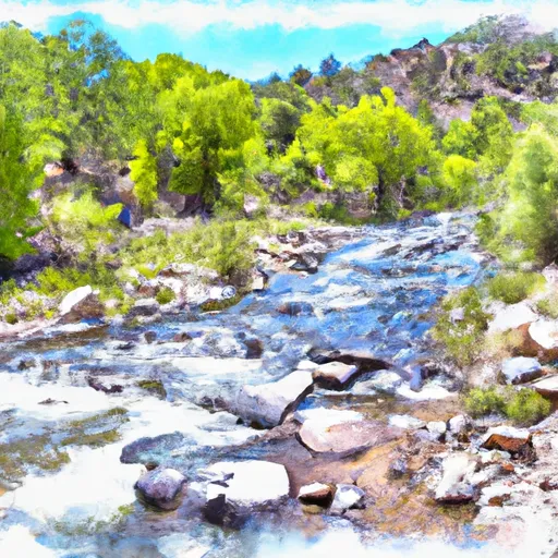
The Whitewater River Run from Headwaters to Confluence with Diamond Creek in the state of New Mexico is a popular route for rafting and kayaking enthusiasts. The ideal streamflow range for this run is between 500 and 800 cubic feet per second (cfs), which is considered moderate to high water flow. The class rating for this section of the river ranges from II to III, which means that it contains moderate rapids with some waves and obstacles that require maneuvering.
The segment mileage for this run is approximately 18 miles, and it takes between 4 and 6 hours to complete. Some of the specific river rapids and obstacles on this run include Pinball, which is a class III rapid that requires precise maneuvering to avoid the rocks and waves. The Grapevine section is also a class III rapid that requires careful navigation through a series of boulders and eddies.
There are specific regulations that apply to this area, including the requirement for all boaters to wear a personal flotation device (PFD) at all times while on the river. Additionally, there are designated take-out points that boaters must use to exit the river and return to their vehicles. It is also important to note that this section of the river is located within the Fort Apache Indian Reservation, and boaters must obtain permits and follow all regulations set forth by the tribe.
Plan your run down to the hour
Same weather feed Snoflo's iOS app uses -- updated continuously from NOAA / yr.no. Watch the precipitation column on the meteogram; rain ahead of a run typically lifts flows 12-48 hours later depending on the basin.
Next 5 days, hour by hour
Temperature line with weather symbols on top, snow + rain accumulation as columns, humidity as a dotted line.
5-day forecast table
Every 3 hours, broken out across temperature, snow, rain, humidity, and wind. Each cell is colour-coded relative to the column min/max.
| Time | Condition | Temp (°F) | Snow (in) | Rain (in) | Humidity (%) | Wind (mps) | Wind dir |
|---|---|---|---|---|---|---|---|
| Loading detailed forecast… | |||||||
15-day temperature & precipitation
Daily temperatures, snow, and rain projected over the next two weeks -- the upstream story that drives next week's flows.
Regional streamflow levels
USGS streamgauges around Headwaters To Confluence With Diamond Creek -- useful for spotting upstream pulses and gauging which tributary is contributing what.
| Streamgauge | Discharge | View |
|---|---|---|
| Mimbres River At Mimbres | 5 cfs | → |
| Gila River Near Gila | 52 cfs | → |
| Mogollon Creek Near Cliff | · | → |
| Rio Grande Below Elephant Butte Dam | · | → |
| Rio Grande At Narrows In Elephant Butte Res. | · | → |
| San Francisco River Near Glenwood | 35 cfs | → |
Plan a longer trip
The closest boat launches, other paddle runs, and campgrounds so a day on the water can grow into a full weekend.
Other river runs
- Headwaters To Junction Of Trails 707/68 (Sec 35, T12s, R11w)
- Headwaters To Aldo Leopold Wilderness Boundary
- Aldo Leopold Wilderness Boundary To Gila Wilderness Boundary
- Gila Wilderness Boundary To Confluence With East Fork Gila River
- Wilderness Run
Campgrounds
- Black Canyon Campground - Upper
- Black Canyon Campground - Lower
- Black Canyon Upper
- Rocky Canyon Campground
- Wall Lake
- Grapevine Campground
Points of interest
Whitewater safety
- Check the flow before you run
- Use the linked-gauge card and Regional Flow panel above. Class ratings change with flow -- a Class III at low water can become Class IV+ at high water.
- Know your skill ceiling
- Pick runs comfortably below your ceiling. Cold-water and big-water runs raise the consequences of any mistake.
- Wear the right gear
- Helmet, PFD, drysuit / wetsuit when water is below 60°F. Throw bag, knife, and whistle on your person, not in the boat.
- Scout, set safety, and run with a team
- Scout new rapids on foot, set safety with throw bags above the consequence pool, and run with at least one other competent paddler.
- Respect the river
- Strainers, undercuts, low-head dams, and wood can kill at any class rating. When in doubt, portage.
Set push alerts in the Snoflo app
Save Headwaters To Confluence With Diamond Creek as a favorite, set a discharge threshold (e.g. "alert me when flow hits 600 cfs"), and the iOS app pushes the moment the linked gauge crosses.
About Headwaters To Confluence With Diamond Creek
What's the optimal flow for Headwaters To Confluence With Diamond Creek?
The optimal flow depends on the section and the craft. Check the Run Details panel for the linked gauge and current status.
How fresh is the cfs reading on this page?
The linked USGS streamgauge reports continuously (every 15 minutes); Snoflo refreshes throughout the day. Hover the streamflow sparkline to read individual datapoints.
What's the whitewater class?
See the Run Details panel for the class rating Snoflo tracks for this run. Class ratings change with flow -- a Class III at low water can become Class IV in high water.
Where do I put in / take out?
Tap Directions in the hero above to open driving directions to the put-in. For shuttle planning, check the Nearby Boat Launches panel and the river run operator's site.
Can I get alerts when flows hit the optimal range?
Yes -- alerts are managed in the Snoflo iOS app. Favorite this run, set a discharge threshold, and you'll get a push the moment the gauge crosses.
Other runs near here
Snoflo-tracked paddle runs within driving distance of Headwaters To Confluence With Diamond Creek.