Headwaters To Western Boundary Of Olympic National Park River Run
Community Reviews
Been here? Share the conditions.
Reviews, ratings & photos are added in the free Snoflo iOS app — rate a spot, tag the conditions, and your visit is verified by location. Add or manage your reviews from the app.
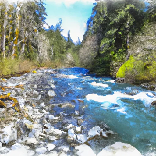
Headwaters To Western Boundary Of Olympic National Park
There are several notable rapids and obstacles along the way, including the "Waffle Wall," a Class IV rapid that demands precision and skill to navigate. "The Slot" is another challenging rapid that requires tight maneuvering to avoid being swept into a narrow chute. Additionally, paddlers should be aware of the "Log Jam," which can present a hazard in high water conditions.
As with all river runs, there are specific regulations to follow to ensure safety and preservation of the environment. Permits are required for overnight trips, and visitors should check with the National Park Service for any additional regulations or closures. It is also important to pack out all trash and respect the natural surroundings to minimize impact.
Plan your run down to the hour
Same weather feed Snoflo's iOS app uses -- updated continuously from NOAA / yr.no. Watch the precipitation column on the meteogram; rain ahead of a run typically lifts flows 12-48 hours later depending on the basin.
Next 5 days, hour by hour
Temperature line with weather symbols on top, snow + rain accumulation as columns, humidity as a dotted line.
5-day forecast table
Every 3 hours, broken out across temperature, snow, rain, humidity, and wind. Each cell is colour-coded relative to the column min/max.
| Time | Condition | Temp (°F) | Snow (in) | Rain (in) | Humidity (%) | Wind (mps) | Wind dir |
|---|---|---|---|---|---|---|---|
| Loading detailed forecast… | |||||||
15-day temperature & precipitation
Daily temperatures, snow, and rain projected over the next two weeks -- the upstream story that drives next week's flows.
Regional streamflow levels
USGS streamgauges around Headwaters To Western Boundary Of Olympic National Park -- useful for spotting upstream pulses and gauging which tributary is contributing what.
| Streamgauge | Discharge | View |
|---|---|---|
| Elwha River Above Lake Mills Nr Port Angeles | 725 cfs | → |
| Elwha River At Mcdonald Br Near Port Angeles | 380 cfs | → |
| Hoh River At Us Highway 101 Near Forks | 602 cfs | → |
| Dungeness River Near Sequim | 126 cfs | → |
| Calawah River Near Forks | 95 cfs | → |
| Nf Skokomish R Bl Staircase Rpds Nr Hoodsport | 52 cfs | → |
Plan a longer trip
The closest boat launches, other paddle runs, and campgrounds so a day on the water can grow into a full weekend.
Boat launches
- Barnes Point
- Lake Sutherland
- Fairholm Campground
- Freshwater Bay County Park
- Whiskey Creek Beach Resort
- Boat Haven West Ramp (Port Angeles)
Other river runs
- Headwaters And Includes All Tributaries To Confluence With Boulder Creek
- Headwaters And Includes All Tributaries To Confluence With Sol Duc River
- Headwaters And Includes All Tributaries To Confluence With Elwha River
Whitewater safety
- Check the flow before you run
- Use the linked-gauge card and Regional Flow panel above. Class ratings change with flow -- a Class III at low water can become Class IV+ at high water.
- Know your skill ceiling
- Pick runs comfortably below your ceiling. Cold-water and big-water runs raise the consequences of any mistake.
- Wear the right gear
- Helmet, PFD, drysuit / wetsuit when water is below 60°F. Throw bag, knife, and whistle on your person, not in the boat.
- Scout, set safety, and run with a team
- Scout new rapids on foot, set safety with throw bags above the consequence pool, and run with at least one other competent paddler.
- Respect the river
- Strainers, undercuts, low-head dams, and wood can kill at any class rating. When in doubt, portage.
Set push alerts in the Snoflo app
Save Headwaters To Western Boundary Of Olympic National Park as a favorite, set a discharge threshold (e.g. "alert me when flow hits 600 cfs"), and the iOS app pushes the moment the linked gauge crosses.
About Headwaters To Western Boundary Of Olympic National Park
What's the optimal flow for Headwaters To Western Boundary Of Olympic National Park?
The optimal flow depends on the section and the craft. Check the Run Details panel for the linked gauge and current status.
How fresh is the cfs reading on this page?
The linked USGS streamgauge reports continuously (every 15 minutes); Snoflo refreshes throughout the day. Hover the streamflow sparkline to read individual datapoints.
What's the whitewater class?
See the Run Details panel for the class rating Snoflo tracks for this run. Class ratings change with flow -- a Class III at low water can become Class IV in high water.
Where do I put in / take out?
Tap Directions in the hero above to open driving directions to the put-in. For shuttle planning, check the Nearby Boat Launches panel and the river run operator's site.
Can I get alerts when flows hit the optimal range?
Yes -- alerts are managed in the Snoflo iOS app. Favorite this run, set a discharge threshold, and you'll get a push the moment the gauge crosses.
Other runs near here
Snoflo-tracked paddle runs within driving distance of Headwaters To Western Boundary Of Olympic National Park.