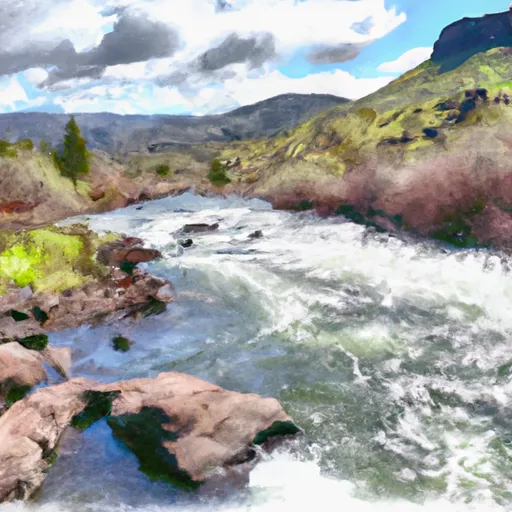
Summit Creek To Mouth Of Little Klickitat River Run
Community Reviews
Been here? Share the conditions.
Reviews, ratings & photos are added in the free Snoflo iOS app — rate a spot, tag the conditions, and your visit is verified by location. Add or manage your reviews from the app.
Summit Creek To Mouth Of Little Klickitat
The Summit Creek to Mouth of Little Klickitat segment is approximately 9 miles long, and takes around 3-4 hours to complete. Along the way, paddlers will encounter several obstacles, including rocks, drops, and chutes. BZ Falls is a particularly challenging rapid, with a steep drop and strong current that requires precise navigation.
There are several regulations in place to ensure the safety of paddlers and the preservation of the environment along the White Salmon River. All boaters are required to wear a personal flotation device, and commercial outfitters must be licensed and adhere to strict safety standards. Additionally, paddlers should be aware of seasonal closures and restrictions, as well as rules regarding camping and littering in the surrounding areas.
Plan your run down to the hour
Same weather feed Snoflo's iOS app uses -- updated continuously from NOAA / yr.no. Watch the precipitation column on the meteogram; rain ahead of a run typically lifts flows 12-48 hours later depending on the basin.
Next 5 days, hour by hour
Temperature line with weather symbols on top, snow + rain accumulation as columns, humidity as a dotted line.
5-day forecast table
Every 3 hours, broken out across temperature, snow, rain, humidity, and wind. Each cell is colour-coded relative to the column min/max.
| Time | Condition | Temp (°F) | Snow (in) | Rain (in) | Humidity (%) | Wind (mps) | Wind dir |
|---|---|---|---|---|---|---|---|
| Loading detailed forecast… | |||||||
15-day temperature & precipitation
Daily temperatures, snow, and rain projected over the next two weeks -- the upstream story that drives next week's flows.
Regional streamflow levels
USGS streamgauges around Summit Creek To Mouth Of Little Klickitat -- useful for spotting upstream pulses and gauging which tributary is contributing what.
| Streamgauge | Discharge | View |
|---|---|---|
| Klickitat River Bl Summit Creek Near Glenwood | 1,820 cfs | → |
| Klickitat River Near Pitt | 767 cfs | → |
| Deschutes River At Moody | 3,830 cfs | → |
| Columbia River At The Dalles | 117,000 cfs | → |
| Mosier Creek Near Mosier | 1 cfs | → |
| White Salmon River Near Underwood | 533 cfs | → |
Plan a longer trip
The closest boat launches, other paddle runs, and campgrounds so a day on the water can grow into a full weekend.
Boat launches
- Mineral Springs
- Stinson Flat Road Klickitat County
- Glenwood Highway Klickitat County
- Avery Park
- Horsethief State Park
- Lewis And Clark Trail Highway Dallesport
Campgrounds
- Mineral Springs - Wdfw
- Canyon Creek Campground
- Soda Springs Campground
- Stimpson Flats - Wdfw
- Stinson Flats Campground
- Leidl South Campground
Whitewater safety
- Check the flow before you run
- Use the linked-gauge card and Regional Flow panel above. Class ratings change with flow -- a Class III at low water can become Class IV+ at high water.
- Know your skill ceiling
- Pick runs comfortably below your ceiling. Cold-water and big-water runs raise the consequences of any mistake.
- Wear the right gear
- Helmet, PFD, drysuit / wetsuit when water is below 60°F. Throw bag, knife, and whistle on your person, not in the boat.
- Scout, set safety, and run with a team
- Scout new rapids on foot, set safety with throw bags above the consequence pool, and run with at least one other competent paddler.
- Respect the river
- Strainers, undercuts, low-head dams, and wood can kill at any class rating. When in doubt, portage.
Set push alerts in the Snoflo app
Save Summit Creek To Mouth Of Little Klickitat as a favorite, set a discharge threshold (e.g. "alert me when flow hits 600 cfs"), and the iOS app pushes the moment the linked gauge crosses.
About Summit Creek To Mouth Of Little Klickitat
What's the optimal flow for Summit Creek To Mouth Of Little Klickitat?
The optimal flow depends on the section and the craft. Check the Run Details panel for the linked gauge and current status.
How fresh is the cfs reading on this page?
The linked USGS streamgauge reports continuously (every 15 minutes); Snoflo refreshes throughout the day. Hover the streamflow sparkline to read individual datapoints.
What's the whitewater class?
See the Run Details panel for the class rating Snoflo tracks for this run. Class ratings change with flow -- a Class III at low water can become Class IV in high water.
Where do I put in / take out?
Tap Directions in the hero above to open driving directions to the put-in. For shuttle planning, check the Nearby Boat Launches panel and the river run operator's site.
Can I get alerts when flows hit the optimal range?
Yes -- alerts are managed in the Snoflo iOS app. Favorite this run, set a discharge threshold, and you'll get a push the moment the gauge crosses.
Other runs near here
Snoflo-tracked paddle runs within driving distance of Summit Creek To Mouth Of Little Klickitat.