Yakima River Segment 2 River Run
Community Reviews
Been here? Share the conditions.
Reviews, ratings & photos are added in the free Snoflo iOS app — rate a spot, tag the conditions, and your visit is verified by location. Add or manage your reviews from the app.
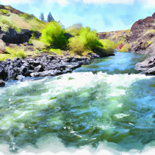
Yakima River Segment 2
Some notable rapids and obstacles along this segment include Big Horn, Roza Dam, and Ringer. These rapids are generally safe to navigate but can pose a challenge to inexperienced paddlers. It is also important to note that the Yakima River is popular for fishing and therefore, boaters should be respectful of local anglers and avoid disturbing their activities.
Specific regulations to the area include the requirement for all boaters to have a Washington state boater education card and wear a personal flotation device (PFD) at all times. Additionally, alcohol is prohibited on the river and littering is strictly enforced. Overall, the Yakima River Segment 2 offers a fun and accessible whitewater experience for paddlers of all levels.
Plan your run down to the hour
Same weather feed Snoflo's iOS app uses -- updated continuously from NOAA / yr.no. Watch the precipitation column on the meteogram; rain ahead of a run typically lifts flows 12-48 hours later depending on the basin.
Next 5 days, hour by hour
Temperature line with weather symbols on top, snow + rain accumulation as columns, humidity as a dotted line.
5-day forecast table
Every 3 hours, broken out across temperature, snow, rain, humidity, and wind. Each cell is colour-coded relative to the column min/max.
| Time | Condition | Temp (°F) | Snow (in) | Rain (in) | Humidity (%) | Wind (mps) | Wind dir |
|---|---|---|---|---|---|---|---|
| Loading detailed forecast… | |||||||
15-day temperature & precipitation
Daily temperatures, snow, and rain projected over the next two weeks -- the upstream story that drives next week's flows.
Regional streamflow levels
USGS streamgauges around Yakima River Segment 2 -- useful for spotting upstream pulses and gauging which tributary is contributing what.
| Streamgauge | Discharge | View |
|---|---|---|
| Yakima River At Umtanum | 3,660 cfs | → |
| Ahtanum Creek At Union Gap | 3 cfs | → |
| Yakima River Above Ahtanum Creek At Union Gap | 2,730 cfs | → |
| Columbia River Below Priest Rapids Dam | 83,500 cfs | → |
| Granger Drain At Granger | 49 cfs | → |
| Crab Creek Near Beverly | 134 cfs | → |
Plan a longer trip
The closest boat launches, other paddle runs, and campgrounds so a day on the water can grow into a full weekend.
Boat launches
- Roza Recreation Site
- Canyon Road 8681-9129, Yakima
- State Route 821 Kittitas County
- Big Pines Campground
Other river runs
- Yakima River Segment 1
- Confluence With Ranier Fork To Confluence With Bumping River
- Headwaters At American Lake To Confluence With Ranier Fork
- Headwaters In Se1/4 Of Sec 9, T14n, R11e To Goat Rocks Wilderness Boundary
- Confluence With Chinook Creek To Southern Boundary Of Mount Rainier National Park
Campgrounds
- Roza - Yakima River Canyon
- Roza Recreation Site
- Roza Campsite 1
- Roza Campsite 2
- Roza Campsite 3
- Roza Campsite 4
Parks
Whitewater safety
- Check the flow before you run
- Use the linked-gauge card and Regional Flow panel above. Class ratings change with flow -- a Class III at low water can become Class IV+ at high water.
- Know your skill ceiling
- Pick runs comfortably below your ceiling. Cold-water and big-water runs raise the consequences of any mistake.
- Wear the right gear
- Helmet, PFD, drysuit / wetsuit when water is below 60°F. Throw bag, knife, and whistle on your person, not in the boat.
- Scout, set safety, and run with a team
- Scout new rapids on foot, set safety with throw bags above the consequence pool, and run with at least one other competent paddler.
- Respect the river
- Strainers, undercuts, low-head dams, and wood can kill at any class rating. When in doubt, portage.
Set push alerts in the Snoflo app
Save Yakima River Segment 2 as a favorite, set a discharge threshold (e.g. "alert me when flow hits 600 cfs"), and the iOS app pushes the moment the linked gauge crosses.
About Yakima River Segment 2
What's the optimal flow for Yakima River Segment 2?
The optimal flow depends on the section and the craft. Check the Run Details panel for the linked gauge and current status.
How fresh is the cfs reading on this page?
The linked USGS streamgauge reports continuously (every 15 minutes); Snoflo refreshes throughout the day. Hover the streamflow sparkline to read individual datapoints.
What's the whitewater class?
See the Run Details panel for the class rating Snoflo tracks for this run. Class ratings change with flow -- a Class III at low water can become Class IV in high water.
Where do I put in / take out?
Tap Directions in the hero above to open driving directions to the put-in. For shuttle planning, check the Nearby Boat Launches panel and the river run operator's site.
Can I get alerts when flows hit the optimal range?
Yes -- alerts are managed in the Snoflo iOS app. Favorite this run, set a discharge threshold, and you'll get a push the moment the gauge crosses.
Other runs near here
Snoflo-tracked paddle runs within driving distance of Yakima River Segment 2.