Salmon Creek River Run
Community Reviews
Been here? Share the conditions.
Reviews, ratings & photos are added in the free Snoflo iOS app — rate a spot, tag the conditions, and your visit is verified by location. Add or manage your reviews from the app.
Salmon Creek
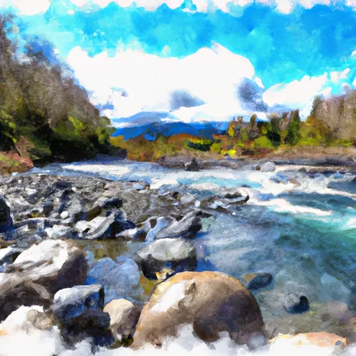
One of the biggest obstacles on the Salmon Creek run is the "The Slot," which is a technical and challenging rapid that requires precise navigation. Another challenging obstacle is "Pinball," which is a boulder garden with multiple channels and tight drops.
In terms of regulations, all paddlers must wear a personal flotation device and helmets are strongly recommended. The use of alcohol and drugs is strictly prohibited on the river. The access point for Salmon Creek is located on private property, so it is important for paddlers to obtain permission from the landowner before accessing the river.
Overall, Salmon Creek is a challenging and technical river run that requires experience and skill. Paddlers should always be aware of the current streamflow and weather conditions before attempting this run.
Plan your run down to the hour
Same weather feed Snoflo's iOS app uses -- updated continuously from NOAA / yr.no. Watch the precipitation column on the meteogram; rain ahead of a run typically lifts flows 12-48 hours later depending on the basin.
Next 5 days, hour by hour
Temperature line with weather symbols on top, snow + rain accumulation as columns, humidity as a dotted line.
5-day forecast table
Every 3 hours, broken out across temperature, snow, rain, humidity, and wind. Each cell is colour-coded relative to the column min/max.
| Time | Condition | Temp (°F) | Snow (in) | Rain (in) | Humidity (%) | Wind (mps) | Wind dir |
|---|---|---|---|---|---|---|---|
| Loading detailed forecast… | |||||||
15-day temperature & precipitation
Daily temperatures, snow, and rain projected over the next two weeks -- the upstream story that drives next week's flows.
Regional streamflow levels
USGS streamgauges around Salmon Creek -- useful for spotting upstream pulses and gauging which tributary is contributing what.
| Streamgauge | Discharge | View |
|---|---|---|
| Okanogan River At Malott | 565 cfs | → |
| Omak Creek Near Omak | 0 cfs | → |
| Okanogan River Near Tonasket | 613 cfs | → |
| Methow River At Twisp | 403 cfs | → |
| Methow River At Winthrop | 297 cfs | → |
| Twisp River Near Twisp | 85 cfs | → |
Plan a longer trip
The closest boat launches, other paddle runs, and campgrounds so a day on the water can grow into a full weekend.
Boat launches
- Green Lake
- Green Lake Road 50-374, Okanogan
- Conconully Road Conconully
- Sinlahekin Road 100-144, Okanogan
- Sinlahekin Road, Okanogan
Other river runs
- Pasayten Wilderness Boundary To Okanogan Nf Boundary
- Private Land Boundary To Okanogan Nf Boundary
- Lake Chelan-Sawtooth Wilderness Boundary To Okanogan Nf Boundary
- Confluence Of South Fork Wolf Creek To Lake Chelan-Sawtooth Wilderness Boundary
- Confluence With Tungsten Creek To Pasayten Wilderness Boundary
Campgrounds
- Rock Lakes- State Forest
- Green Lake - Wdfw
- Green Lake
- Liar's Cove Resort
- Conconully State Park
- Rock Creek- State Forest
Parks
- Conconully State Park
- Sinlahekin Deer Winter Range And Wildlife Refuge
- Omak Eastside Park
- Methow Winter Range And Wildlife Refuge
Points of interest
Whitewater safety
- Check the flow before you run
- Use the linked-gauge card and Regional Flow panel above. Class ratings change with flow -- a Class III at low water can become Class IV+ at high water.
- Know your skill ceiling
- Pick runs comfortably below your ceiling. Cold-water and big-water runs raise the consequences of any mistake.
- Wear the right gear
- Helmet, PFD, drysuit / wetsuit when water is below 60°F. Throw bag, knife, and whistle on your person, not in the boat.
- Scout, set safety, and run with a team
- Scout new rapids on foot, set safety with throw bags above the consequence pool, and run with at least one other competent paddler.
- Respect the river
- Strainers, undercuts, low-head dams, and wood can kill at any class rating. When in doubt, portage.
Set push alerts in the Snoflo app
Save Salmon Creek as a favorite, set a discharge threshold (e.g. "alert me when flow hits 600 cfs"), and the iOS app pushes the moment the linked gauge crosses.
About Salmon Creek
What's the optimal flow for Salmon Creek?
The optimal flow depends on the section and the craft. Check the Run Details panel for the linked gauge and current status.
How fresh is the cfs reading on this page?
The linked USGS streamgauge reports continuously (every 15 minutes); Snoflo refreshes throughout the day. Hover the streamflow sparkline to read individual datapoints.
What's the whitewater class?
See the Run Details panel for the class rating Snoflo tracks for this run. Class ratings change with flow -- a Class III at low water can become Class IV in high water.
Where do I put in / take out?
Tap Directions in the hero above to open driving directions to the put-in. For shuttle planning, check the Nearby Boat Launches panel and the river run operator's site.
Can I get alerts when flows hit the optimal range?
Yes -- alerts are managed in the Snoflo iOS app. Favorite this run, set a discharge threshold, and you'll get a push the moment the gauge crosses.
Other runs near here
Snoflo-tracked paddle runs within driving distance of Salmon Creek.