Glady Fork River To Otter Creek River Run
Community Reviews
Been here? Share the conditions.
Reviews, ratings & photos are added in the free Snoflo iOS app — rate a spot, tag the conditions, and your visit is verified by location. Add or manage your reviews from the app.
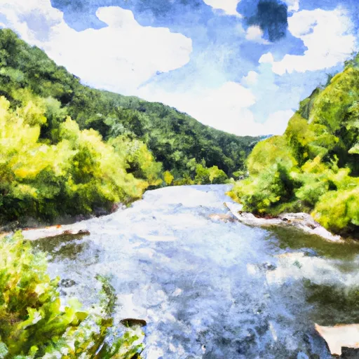
Glady Fork River To Otter Creek
The segment is rated as a Class II-III, which means it has moderate rapids and obstacles that require some maneuvering skills. The total distance of this river run is approximately 10 miles, starting at the Glady Fork River and ending at Otter Creek.
Some of the major rapids and obstacles that paddlers will encounter during this river run include the Bemis Rapid, the Double Z Rapid, and the Big Rock Rapid. These rapids offer exciting challenges for paddlers to navigate through.
It is important to note that the area has specific regulations to protect the natural environment and wildlife. Paddlers are required to follow Leave No Trace principles, which include packing out all trash and minimizing impact on the environment. Additionally, paddlers are required to wear a personal flotation device (PFD) at all times while on the river.
Overall, the Glady Fork River to Otter Creek river run offers a fun and challenging experience for paddlers. It is important to check the streamflow before embarking on this adventure and to follow all regulations to protect the natural environment.
Plan your run down to the hour
Same weather feed Snoflo's iOS app uses -- updated continuously from NOAA / yr.no. Watch the precipitation column on the meteogram; rain ahead of a run typically lifts flows 12-48 hours later depending on the basin.
Next 5 days, hour by hour
Temperature line with weather symbols on top, snow + rain accumulation as columns, humidity as a dotted line.
5-day forecast table
Every 3 hours, broken out across temperature, snow, rain, humidity, and wind. Each cell is colour-coded relative to the column min/max.
| Time | Condition | Temp (°F) | Snow (in) | Rain (in) | Humidity (%) | Wind (mps) | Wind dir |
|---|---|---|---|---|---|---|---|
| Loading detailed forecast… | |||||||
15-day temperature & precipitation
Daily temperatures, snow, and rain projected over the next two weeks -- the upstream story that drives next week's flows.
Regional streamflow levels
USGS streamgauges around Glady Fork River To Otter Creek -- useful for spotting upstream pulses and gauging which tributary is contributing what.
| Streamgauge | Discharge | View |
|---|---|---|
| Dry Fork At Hendricks | 182 cfs | → |
| Cheat River Near Parsons | 564 cfs | → |
| Blackwater R At Davis | 38 cfs | → |
| Blackwater R Nr Davis | 132 cfs | → |
| Shavers Fork Below Bowden | 134 cfs | → |
| Tygart Valley River At Belington | 186 cfs | → |
Plan a longer trip
The closest boat launches, other paddle runs, and campgrounds so a day on the water can grow into a full weekend.
Other river runs
- Enter Otter Creek Wilderness To Exit Otter Creek Wilderness
- Otter Creek To Blackwater
- North Fork To Hickory Lick Run
- Waterfall Run To Dry Fork
- Laurel Fork River To Glady Fork River
Campgrounds
- Brian's Place
- Blackwater Falls State Park
- Bear Heaven Campground
- Horseshoe Recreation And Campground Area
- Cooper's Campground
- Campsite 5
Fishing spots
Whitewater safety
- Check the flow before you run
- Use the linked-gauge card and Regional Flow panel above. Class ratings change with flow -- a Class III at low water can become Class IV+ at high water.
- Know your skill ceiling
- Pick runs comfortably below your ceiling. Cold-water and big-water runs raise the consequences of any mistake.
- Wear the right gear
- Helmet, PFD, drysuit / wetsuit when water is below 60°F. Throw bag, knife, and whistle on your person, not in the boat.
- Scout, set safety, and run with a team
- Scout new rapids on foot, set safety with throw bags above the consequence pool, and run with at least one other competent paddler.
- Respect the river
- Strainers, undercuts, low-head dams, and wood can kill at any class rating. When in doubt, portage.
Set push alerts in the Snoflo app
Save Glady Fork River To Otter Creek as a favorite, set a discharge threshold (e.g. "alert me when flow hits 600 cfs"), and the iOS app pushes the moment the linked gauge crosses.
About Glady Fork River To Otter Creek
What's the optimal flow for Glady Fork River To Otter Creek?
The optimal flow depends on the section and the craft. Check the Run Details panel for the linked gauge and current status.
How fresh is the cfs reading on this page?
The linked USGS streamgauge reports continuously (every 15 minutes); Snoflo refreshes throughout the day. Hover the streamflow sparkline to read individual datapoints.
What's the whitewater class?
See the Run Details panel for the class rating Snoflo tracks for this run. Class ratings change with flow -- a Class III at low water can become Class IV in high water.
Where do I put in / take out?
Tap Directions in the hero above to open driving directions to the put-in. For shuttle planning, check the Nearby Boat Launches panel and the river run operator's site.
Can I get alerts when flows hit the optimal range?
Yes -- alerts are managed in the Snoflo iOS app. Favorite this run, set a discharge threshold, and you'll get a push the moment the gauge crosses.
Other runs near here
Snoflo-tracked paddle runs within driving distance of Glady Fork River To Otter Creek.