Community Reviews
Been here? Share the conditions.
Reviews, ratings & photos are added in the free Snoflo iOS app — rate a spot, tag the conditions, and your visit is verified by location. Add or manage your reviews from the app.

Watson Lake Park
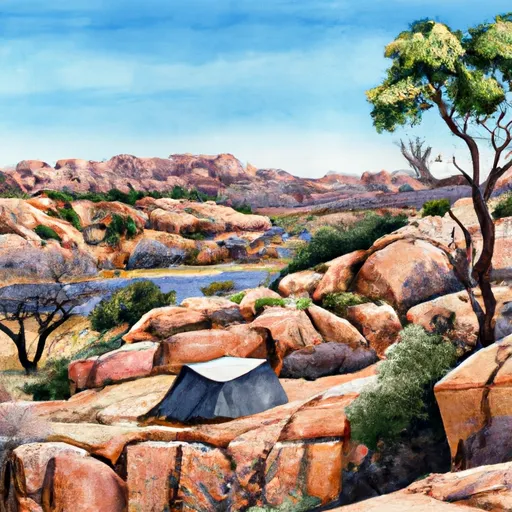
One of the primary attractions at Watson Lake Park is its picturesque lake, which is surrounded by unique granite formations. The lake provides a serene setting for various water activities, such as kayaking, canoeing, fishing, and boating. Visitors can rent watercraft or bring their own to explore the crystal-clear waters, numerous coves, and hidden beaches.
Hiking enthusiasts will find plenty of trails to explore within the park. The Peavine National Recreation Trail, which runs through Watson Lake Park, offers a scenic route for hiking, biking, and horseback riding. The trail provides stunning views of the park and its surrounding landscapes, making it a must-visit for outdoor enthusiasts.
In addition to its natural beauty, Watson Lake Park is known for its unique rock formations. These granite boulders, formed over millions of years, create an otherworldly landscape that attracts photographers, geology enthusiasts, and nature lovers. The park also features several picnic areas with panoramic views, providing a perfect spot to relax and enjoy a meal amidst the breathtaking surroundings.
Interesting facts about Watson Lake Park include its origins as a man-made reservoir formed in the early 1900s and its role in providing water to the city of Prescott. The park was officially established in 1973 and has since become a popular destination for locals and tourists alike.
The best time to visit Watson Lake Park is during the spring (March to May) and fall (September to November) seasons. During these times, the weather is generally pleasant, with mild temperatures and less chance of rain. In spring, the park comes alive with colorful wildflowers, while fall offers stunning foliage, creating a truly magical experience.
To ensure the accuracy of the information, it is recommended to verify the details mentioned above across multiple independent sources, such as official park websites, travel guides, and local tourism information.
Camping in Watson Lake Park
Campgrounds inside the park, with today's conditions score.
Plan your visit down to the hour
Same weather feed Snoflo's iOS app uses -- updated continuously from NOAA / yr.no.
Next 5 days, hour by hour
Temperature line with weather symbols on top, snow + rain accumulation as columns, humidity as a dotted line.
5-day forecast table
Every 3 hours, broken out across temperature, snow, rain, humidity, and wind.
| Time | Condition | Temp (°F) | Snow (in) | Rain (in) | Humidity (%) | Wind (mps) | Wind dir |
|---|---|---|---|---|---|---|---|
| Loading detailed forecast… | |||||||
15-day temperature & precipitation
Daily temperatures, snow, and rain projected over the next two weeks.
Responsible recreation & Leave No Trace
- Know before you go
- Check the operator's site for hours, permit requirements, seasonal closures, and fire restrictions before heading out.
- Stay on trail
- Stick to marked paths to protect vegetation, prevent erosion, and avoid disturbing wildlife habitat.
- Respect wildlife
- Observe from a distance, never feed wildlife, and store food securely if camping is permitted on-site.
- Pack it in, pack it out
- Carry out all trash, food scraps, and gear. Many parks have limited or no trash service.
- Leave what you find
- Don't take rocks, plants, or artifacts. They make the park what it is for the next visitor.
Set push alerts in the Snoflo app
Save Watson Lake Park as a favorite, set a custom threshold (precipitation, freezing temperatures, fire-restriction days), and the iOS app will push the moment conditions cross.
About Watson Lake Park
What can I do at Watson Lake Park?
Most Snoflo-tracked parks support hiking, picnicking, and wildlife viewing. Check the operator's site for activity-specific rules (camping, fishing, paddling, hunting).
How fresh is the weather data?
The hourly forecast updates throughout the day from NOAA / yr.no. Streamflow comes live from USGS streamgauges.
When is the best time to visit?
Use the 15-day temperature & precipitation outlook on this page to plan -- pick a window with comfortable temperatures and low precipitation.
How do I get to Watson Lake Park?
Tap Directions in the hero above to open driving directions in Google Maps, or Open in map to center the Snoflo interactive map on the park.
Can I get alerts when conditions change?
Yes -- alerts are managed in the Snoflo iOS app. Favorite this park, set a threshold (temperature, precipitation), and you'll get a push the moment it crosses.
Park & land designation reference
A quick legend for the federal and state land categories Snoflo tracks. Each designation comes with different rules around access, recreation, and resource extraction.
- National Park
- Large protected natural areas managed by the federal government to preserve significant landscapes, ecosystems, and cultural resources; recreation is allowed but conservation is the priority.
- State Park
- Public natural or recreational areas managed by a state government, typically smaller than national parks and focused on regional natural features, recreation, and education.
- Local Park
- Community-level parks managed by cities or counties, emphasizing recreation, playgrounds, sports, and green space close to populated areas.
- Wilderness Area
- The highest level of land protection in the U.S.; designated areas where nature is left essentially untouched, with no roads, structures, or motorized motorized access permitted.
- National Recreation Area
- Areas set aside primarily for outdoor recreation (boating, hiking, fishing, often around reservoirs, rivers, or scenic landscapes); may allow more development.
- National Conservation Area (BLM)
- BLM-managed areas with special ecological, cultural, or scientific value; more protection than typical BLM land but less strict than Wilderness Areas.
- State Forest
- State-managed forests focused on habitat, watershed, recreation, and sustainable timber harvest.
- Bureau of Land Management (BLM) Land
- Vast federal lands managed for mixed use -- recreation, grazing, mining, conservation -- with fewer restrictions than national parks or forests.