Community Reviews
Been here? Share the conditions.
Reviews, ratings & photos are added in the free Snoflo iOS app — rate a spot, tag the conditions, and your visit is verified by location. Add or manage your reviews from the app.
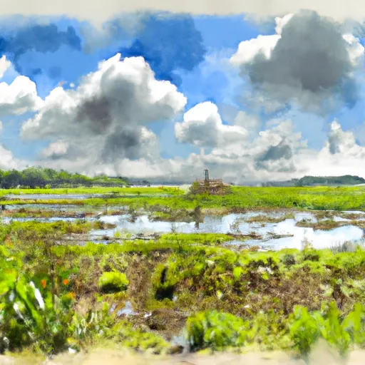
Sabine National Wildlife Refuge
Sabine National Wildlife Refuge is an expansive natural area covering over 125,000 acres and is managed by the U.S. Fish and Wildlife Service. It is a popular destination for nature enthusiasts and wildlife lovers due to its diverse ecosystems and abundant wildlife.
Reasons to visit:
1. Biodiversity: Sabine National Wildlife Refuge boasts a wide variety of habitats, including marshes, prairies, forests, and open water. These habitats support a rich diversity of plant and animal species.
2. Birdwatching: The refuge is a renowned destination for birdwatching, with over 200 species of birds recorded. It is an important stopover site for migratory birds, including waterfowl, shorebirds, and wading birds.
3. Wildlife Watching: Visitors have the opportunity to observe various wildlife species, including alligators, river otters, deer, bobcats, and numerous fish species.
4. Photography: The picturesque landscapes and abundant wildlife provide excellent opportunities for nature photography.
5. Fishing and Hunting: Sabine National Wildlife Refuge offers fishing and hunting opportunities for recreational purposes. Regulations may apply, so it is advisable to check with the refuge authorities for specific guidelines.
Points of interest:
1. Wetland Walkway: This elevated boardwalk provides visitors with a unique perspective of the wetland ecosystem, allowing them to observe plants, birds, and other wildlife up close.
2. Wildlife Drive: The refuge features a scenic drive that allows visitors to explore various habitats while looking for wildlife. The drive provides multiple viewpoints and opportunities for photography.
3. McIlhenny Trail: This trail winds through a saltwater marsh and is a great place to spot alligators, wading birds, and other marshland species.
Interesting facts:
1. Sabine National Wildlife Refuge was established in 1937 to provide habitat for migratory birds and other wildlife.
2. The refuge is named after the Sabine River, which forms a portion of its western boundary.
3. It is part of the larger Southwest Louisiana National Wildlife Refuge Complex, which also includes Cameron Prairie and Lacassine National Wildlife Refuges.
Best time to visit:
The best time to visit Sabine National Wildlife Refuge is during the fall and winter months (October to March) when migratory birds are present in large numbers. The weather is generally mild during this time, and the refuge offers guided tours and interpretive programs. However, it is advisable to check with the refuge for up-to-date information on weather conditions and seasonal wildlife sightings.
Please note that the accuracy of this information is based on various independent sources, but it is always recommended to verify specific details or check for any updates directly with Sabine National Wildlife Refuge authorities.
Plan your visit down to the hour
Same weather feed Snoflo's iOS app uses -- updated continuously from NOAA / yr.no.
Next 5 days, hour by hour
Temperature line with weather symbols on top, snow + rain accumulation as columns, humidity as a dotted line.
5-day forecast table
Every 3 hours, broken out across temperature, snow, rain, humidity, and wind.
| Time | Condition | Temp (°F) | Snow (in) | Rain (in) | Humidity (%) | Wind (mps) | Wind dir |
|---|---|---|---|---|---|---|---|
| Loading detailed forecast… | |||||||
15-day temperature & precipitation
Daily temperatures, snow, and rain projected over the next two weeks.
Responsible recreation & Leave No Trace
- Know before you go
- Check the operator's site for hours, permit requirements, seasonal closures, and fire restrictions before heading out.
- Stay on trail
- Stick to marked paths to protect vegetation, prevent erosion, and avoid disturbing wildlife habitat.
- Respect wildlife
- Observe from a distance, never feed wildlife, and store food securely if camping is permitted on-site.
- Pack it in, pack it out
- Carry out all trash, food scraps, and gear. Many parks have limited or no trash service.
- Leave what you find
- Don't take rocks, plants, or artifacts. They make the park what it is for the next visitor.
Set push alerts in the Snoflo app
Save Sabine National Wildlife Refuge as a favorite, set a custom threshold (precipitation, freezing temperatures, fire-restriction days), and the iOS app will push the moment conditions cross.
About Sabine National Wildlife Refuge
What can I do at Sabine National Wildlife Refuge?
Most Snoflo-tracked parks support hiking, picnicking, and wildlife viewing. Check the operator's site for activity-specific rules (camping, fishing, paddling, hunting).
How fresh is the weather data?
The hourly forecast updates throughout the day from NOAA / yr.no. Streamflow comes live from USGS streamgauges.
When is the best time to visit?
Use the 15-day temperature & precipitation outlook on this page to plan -- pick a window with comfortable temperatures and low precipitation.
How do I get to Sabine National Wildlife Refuge?
Tap Directions in the hero above to open driving directions in Google Maps, or Open in map to center the Snoflo interactive map on the park.
Can I get alerts when conditions change?
Yes -- alerts are managed in the Snoflo iOS app. Favorite this park, set a threshold (temperature, precipitation), and you'll get a push the moment it crosses.
Park & land designation reference
A quick legend for the federal and state land categories Snoflo tracks. Each designation comes with different rules around access, recreation, and resource extraction.
- National Park
- Large protected natural areas managed by the federal government to preserve significant landscapes, ecosystems, and cultural resources; recreation is allowed but conservation is the priority.
- State Park
- Public natural or recreational areas managed by a state government, typically smaller than national parks and focused on regional natural features, recreation, and education.
- Local Park
- Community-level parks managed by cities or counties, emphasizing recreation, playgrounds, sports, and green space close to populated areas.
- Wilderness Area
- The highest level of land protection in the U.S.; designated areas where nature is left essentially untouched, with no roads, structures, or motorized motorized access permitted.
- National Recreation Area
- Areas set aside primarily for outdoor recreation (boating, hiking, fishing, often around reservoirs, rivers, or scenic landscapes); may allow more development.
- National Conservation Area (BLM)
- BLM-managed areas with special ecological, cultural, or scientific value; more protection than typical BLM land but less strict than Wilderness Areas.
- State Forest
- State-managed forests focused on habitat, watershed, recreation, and sustainable timber harvest.
- Bureau of Land Management (BLM) Land
- Vast federal lands managed for mixed use -- recreation, grazing, mining, conservation -- with fewer restrictions than national parks or forests.