Russian Gulch State Park
Community Reviews
Been here? Share the conditions.
Reviews, ratings & photos are added in the free Snoflo iOS app — rate a spot, tag the conditions, and your visit is verified by location. Add or manage your reviews from the app.
Russian Gulch State Park
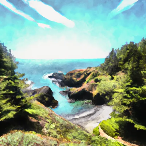
One of the main reasons to visit Russian Gulch State Park is its breathtaking scenery. The park's most prominent feature is the Russian Gulch Creek, which cuts through the lush forest and descends into a picturesque 36-foot waterfall that cascades into the Pacific Ocean. This waterfall is a must-see and offers an excellent opportunity for photography and hiking.
Another point of interest within the park is the Devil's Punchbowl, a collapsed sea cave that has formed a natural sinkhole with a small beach at its base. This unique geological formation creates a mesmerizing sight, especially during high tide when the waves crash into the sinkhole.
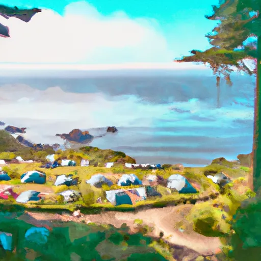
For outdoor enthusiasts, Russian Gulch State Park offers an extensive network of trails for hiking, biking, and horseback riding. The most popular trail is the 5.8-mile-long Headlands Trail, which winds along the coastal cliffs, providing breathtaking views of the rugged coastline. Additionally, the park has a campground with 30 sites, as well as picnic areas and a visitor center.
Interesting facts about Russian Gulch State Park include its historical significance. The park was established in 1933 and was one of the first units of the California State Park System. It was named after Russian Gulch, a small rocky cove where, according to local lore, a group of Russian fur traders sought shelter in the early 19th century.
The best time to visit Russian Gulch State Park is during the spring and fall seasons. Spring offers mild temperatures, blooming wildflowers, and the chance to witness migrating gray whales offshore. Fall, on the other hand, provides visitors with pleasant weather, fewer crowds, and the opportunity to witness the stunning fall foliage in the surrounding forest.
To ensure accuracy, it is recommended to verify the information provided by referring to official sources such as the official California State Parks website and local tourism websites for Mendocino County.
Trails in Russian Gulch State Park
Named trails whose route falls inside the park.
Camping in Russian Gulch State Park
Campgrounds inside the park, with today's conditions score.
Plan your visit down to the hour
Same weather feed Snoflo's iOS app uses -- updated continuously from NOAA / yr.no.
Next 5 days, hour by hour
Temperature line with weather symbols on top, snow + rain accumulation as columns, humidity as a dotted line.
5-day forecast table
Every 3 hours, broken out across temperature, snow, rain, humidity, and wind.
| Time | Condition | Temp (°F) | Snow (in) | Rain (in) | Humidity (%) | Wind (mps) | Wind dir |
|---|---|---|---|---|---|---|---|
| Loading detailed forecast… | |||||||
15-day temperature & precipitation
Daily temperatures, snow, and rain projected over the next two weeks.
Responsible recreation & Leave No Trace
- Know before you go
- Check the operator's site for hours, permit requirements, seasonal closures, and fire restrictions before heading out.
- Stay on trail
- Stick to marked paths to protect vegetation, prevent erosion, and avoid disturbing wildlife habitat.
- Respect wildlife
- Observe from a distance, never feed wildlife, and store food securely if camping is permitted on-site.
- Pack it in, pack it out
- Carry out all trash, food scraps, and gear. Many parks have limited or no trash service.
- Leave what you find
- Don't take rocks, plants, or artifacts. They make the park what it is for the next visitor.
Set push alerts in the Snoflo app
Save Russian Gulch State Park as a favorite, set a custom threshold (precipitation, freezing temperatures, fire-restriction days), and the iOS app will push the moment conditions cross.
About Russian Gulch State Park
What can I do at Russian Gulch State Park?
Most Snoflo-tracked parks support hiking, picnicking, and wildlife viewing. Check the operator's site for activity-specific rules (camping, fishing, paddling, hunting).
How fresh is the weather data?
The hourly forecast updates throughout the day from NOAA / yr.no. Streamflow comes live from USGS streamgauges.
When is the best time to visit?
Use the 15-day temperature & precipitation outlook on this page to plan -- pick a window with comfortable temperatures and low precipitation.
How do I get to Russian Gulch State Park?
Tap Directions in the hero above to open driving directions in Google Maps, or Open in map to center the Snoflo interactive map on the park.
Can I get alerts when conditions change?
Yes -- alerts are managed in the Snoflo iOS app. Favorite this park, set a threshold (temperature, precipitation), and you'll get a push the moment it crosses.
Park & land designation reference
A quick legend for the federal and state land categories Snoflo tracks. Each designation comes with different rules around access, recreation, and resource extraction.
- National Park
- Large protected natural areas managed by the federal government to preserve significant landscapes, ecosystems, and cultural resources; recreation is allowed but conservation is the priority.
- State Park
- Public natural or recreational areas managed by a state government, typically smaller than national parks and focused on regional natural features, recreation, and education.
- Local Park
- Community-level parks managed by cities or counties, emphasizing recreation, playgrounds, sports, and green space close to populated areas.
- Wilderness Area
- The highest level of land protection in the U.S.; designated areas where nature is left essentially untouched, with no roads, structures, or motorized motorized access permitted.
- National Recreation Area
- Areas set aside primarily for outdoor recreation (boating, hiking, fishing, often around reservoirs, rivers, or scenic landscapes); may allow more development.
- National Conservation Area (BLM)
- BLM-managed areas with special ecological, cultural, or scientific value; more protection than typical BLM land but less strict than Wilderness Areas.
- State Forest
- State-managed forests focused on habitat, watershed, recreation, and sustainable timber harvest.
- Bureau of Land Management (BLM) Land
- Vast federal lands managed for mixed use -- recreation, grazing, mining, conservation -- with fewer restrictions than national parks or forests.