Tybee National Wildlife Refuge
Community Reviews
Been here? Share the conditions.
Reviews, ratings & photos are added in the free Snoflo iOS app — rate a spot, tag the conditions, and your visit is verified by location. Add or manage your reviews from the app.
Tybee National Wildlife Refuge
Reasons to Visit:
1. Wildlife Viewing: The refuge offers excellent opportunities for birdwatching, especially during the migration seasons. It provides critical habitat for various bird species, including endangered and threatened species.
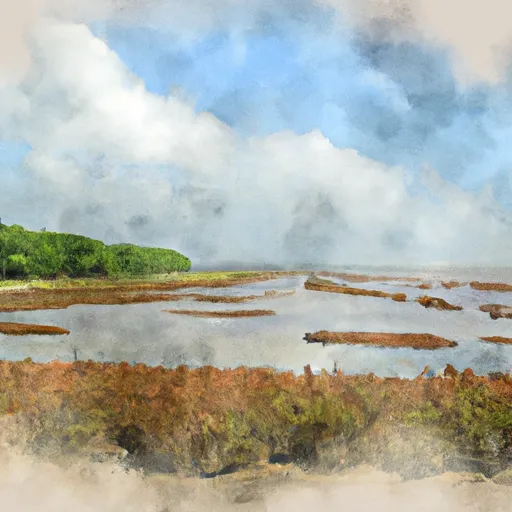
2. Nature Photography: With its diverse ecosystems, including salt marshes, tidal creeks, and maritime forests, the refuge provides beautiful landscapes and wildlife subjects for photographers.
3. Outdoor Recreation: Visitors can enjoy activities like hiking, wildlife observation, and environmental education programs provided by the refuge.
Points of Interest:
1. Tybee Island Beach: The refuge is adjacent to the beautiful Tybee Island Beach, providing a perfect combination of coastal and wildlife experiences.
2. McQueen's Island Historic Trail: This 6-mile trail, located near the refuge, offers a glimpse into the area's history, including the remnants of a 19th-century railroad.
3. Tybee Island Lighthouse: Located nearby, this historic lighthouse offers panoramic views of the island and surrounding coastal areas.
Interesting Facts:
1. Bird Species: The refuge attracts a wide variety of bird species, such as roseate spoonbills, black skimmers, wood storks, and many others.
2. Endangered Species: Tybee National Wildlife Refuge provides critical habitat for endangered loggerhead sea turtles, which nest on the island's beaches.
3. Conservation Efforts: The refuge actively engages in efforts to protect and conserve the unique ecosystems of Tybee Island, safeguarding both resident and migratory bird species.
Best Time to Visit:
The best time to visit Tybee National Wildlife Refuge is during the spring and fall migration seasons. From March to May and September to November, the refuge becomes a hub for various bird species as they pass through or settle in the area. However, the refuge offers year-round wildlife viewing opportunities, so any time of the year can be rewarding.
It is essential to verify up-to-date information about visiting the Tybee National Wildlife Refuge from multiple independent sources, such as the official website of the U.S. Fish and Wildlife Service or local tourism websites, to ensure accuracy and obtain additional details about specific programs or regulations.
Plan your visit down to the hour
Same weather feed Snoflo's iOS app uses -- updated continuously from NOAA / yr.no.
Next 5 days, hour by hour
Temperature line with weather symbols on top, snow + rain accumulation as columns, humidity as a dotted line.
5-day forecast table
Every 3 hours, broken out across temperature, snow, rain, humidity, and wind.
| Time | Condition | Temp (°F) | Snow (in) | Rain (in) | Humidity (%) | Wind (mps) | Wind dir |
|---|---|---|---|---|---|---|---|
| Loading detailed forecast… | |||||||
15-day temperature & precipitation
Daily temperatures, snow, and rain projected over the next two weeks.
Responsible recreation & Leave No Trace
- Know before you go
- Check the operator's site for hours, permit requirements, seasonal closures, and fire restrictions before heading out.
- Stay on trail
- Stick to marked paths to protect vegetation, prevent erosion, and avoid disturbing wildlife habitat.
- Respect wildlife
- Observe from a distance, never feed wildlife, and store food securely if camping is permitted on-site.
- Pack it in, pack it out
- Carry out all trash, food scraps, and gear. Many parks have limited or no trash service.
- Leave what you find
- Don't take rocks, plants, or artifacts. They make the park what it is for the next visitor.
Set push alerts in the Snoflo app
Save Tybee National Wildlife Refuge as a favorite, set a custom threshold (precipitation, freezing temperatures, fire-restriction days), and the iOS app will push the moment conditions cross.
About Tybee National Wildlife Refuge
What can I do at Tybee National Wildlife Refuge?
Most Snoflo-tracked parks support hiking, picnicking, and wildlife viewing. Check the operator's site for activity-specific rules (camping, fishing, paddling, hunting).
How fresh is the weather data?
The hourly forecast updates throughout the day from NOAA / yr.no. Streamflow comes live from USGS streamgauges.
When is the best time to visit?
Use the 15-day temperature & precipitation outlook on this page to plan -- pick a window with comfortable temperatures and low precipitation.
How do I get to Tybee National Wildlife Refuge?
Tap Directions in the hero above to open driving directions in Google Maps, or Open in map to center the Snoflo interactive map on the park.
Can I get alerts when conditions change?
Yes -- alerts are managed in the Snoflo iOS app. Favorite this park, set a threshold (temperature, precipitation), and you'll get a push the moment it crosses.
Park & land designation reference
A quick legend for the federal and state land categories Snoflo tracks. Each designation comes with different rules around access, recreation, and resource extraction.
- National Park
- Large protected natural areas managed by the federal government to preserve significant landscapes, ecosystems, and cultural resources; recreation is allowed but conservation is the priority.
- State Park
- Public natural or recreational areas managed by a state government, typically smaller than national parks and focused on regional natural features, recreation, and education.
- Local Park
- Community-level parks managed by cities or counties, emphasizing recreation, playgrounds, sports, and green space close to populated areas.
- Wilderness Area
- The highest level of land protection in the U.S.; designated areas where nature is left essentially untouched, with no roads, structures, or motorized motorized access permitted.
- National Recreation Area
- Areas set aside primarily for outdoor recreation (boating, hiking, fishing, often around reservoirs, rivers, or scenic landscapes); may allow more development.
- National Conservation Area (BLM)
- BLM-managed areas with special ecological, cultural, or scientific value; more protection than typical BLM land but less strict than Wilderness Areas.
- State Forest
- State-managed forests focused on habitat, watershed, recreation, and sustainable timber harvest.
- Bureau of Land Management (BLM) Land
- Vast federal lands managed for mixed use -- recreation, grazing, mining, conservation -- with fewer restrictions than national parks or forests.