Community Reviews
Been here? Share the conditions.
Reviews, ratings & photos are added in the free Snoflo iOS app — rate a spot, tag the conditions, and your visit is verified by location. Add or manage your reviews from the app.
Wailua Valley State Wayside Park
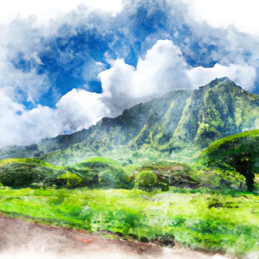
One of the primary reasons to visit Wailua Valley State Wayside Park is its natural beauty. The park is a haven for nature enthusiasts, photographers, and those seeking tranquility in a picturesque setting. With its expansive vistas and emerald landscapes, the park offers numerous opportunities for hiking and exploring. Visitors can take leisurely walks along the trails, capturing amazing views of the Wailua River winding its way through the valley. The park's lookout points provide stunning panoramic views of the valley, offering a true feast for the eyes.
One of the highlights of the park is Opaekaa Falls, which is easily accessible from the wayside area. This 151-foot waterfall is a mesmerizing sight to behold, surrounded by dense vegetation and towering cliffs. Visitors can enjoy the view from the park's viewpoint or take a short hike to get a closer look. Another point of interest is the Wailua River, which is the only navigable river in Hawaii. Visitors can enjoy a peaceful kayak or boat ride along the river, or even take guided tours to explore the hidden gems of the valley.
Interesting facts about Wailua Valley State Wayside Park include its historical significance. It is believed that ancient Hawaiian royals once resided in the area, and numerous ancient Hawaiian temples called heiaus can still be found within the park. These sacred sites offer a glimpse into Hawaii's rich cultural and historical heritage.
The best time of year to visit Wailua Valley State Wayside Park is during the dry season, which typically falls between April and October. During this time, visitors can enjoy pleasant weather and clearer views. It is advisable to check weather conditions and park accessibility before planning a visit, as heavy rainfall can occasionally make the park inaccessible or limit certain activities.
To ensure accuracy, it is recommended to verify the information provided by consulting multiple independent sources such as official state park websites, travel guides, and reputable travel blogs.
Plan your visit down to the hour
Same weather feed Snoflo's iOS app uses -- updated continuously from NOAA / yr.no.
Next 5 days, hour by hour
Temperature line with weather symbols on top, snow + rain accumulation as columns, humidity as a dotted line.
5-day forecast table
Every 3 hours, broken out across temperature, snow, rain, humidity, and wind.
| Time | Condition | Temp (°F) | Snow (in) | Rain (in) | Humidity (%) | Wind (mps) | Wind dir |
|---|---|---|---|---|---|---|---|
| Loading detailed forecast… | |||||||
15-day temperature & precipitation
Daily temperatures, snow, and rain projected over the next two weeks.
Responsible recreation & Leave No Trace
- Know before you go
- Check the operator's site for hours, permit requirements, seasonal closures, and fire restrictions before heading out.
- Stay on trail
- Stick to marked paths to protect vegetation, prevent erosion, and avoid disturbing wildlife habitat.
- Respect wildlife
- Observe from a distance, never feed wildlife, and store food securely if camping is permitted on-site.
- Pack it in, pack it out
- Carry out all trash, food scraps, and gear. Many parks have limited or no trash service.
- Leave what you find
- Don't take rocks, plants, or artifacts. They make the park what it is for the next visitor.
Set push alerts in the Snoflo app
Save Wailua Valley State Wayside Park as a favorite, set a custom threshold (precipitation, freezing temperatures, fire-restriction days), and the iOS app will push the moment conditions cross.
About Wailua Valley State Wayside Park
What can I do at Wailua Valley State Wayside Park?
Most Snoflo-tracked parks support hiking, picnicking, and wildlife viewing. Check the operator's site for activity-specific rules (camping, fishing, paddling, hunting).
How fresh is the weather data?
The hourly forecast updates throughout the day from NOAA / yr.no. Streamflow comes live from USGS streamgauges.
When is the best time to visit?
Use the 15-day temperature & precipitation outlook on this page to plan -- pick a window with comfortable temperatures and low precipitation.
How do I get to Wailua Valley State Wayside Park?
Tap Directions in the hero above to open driving directions in Google Maps, or Open in map to center the Snoflo interactive map on the park.
Can I get alerts when conditions change?
Yes -- alerts are managed in the Snoflo iOS app. Favorite this park, set a threshold (temperature, precipitation), and you'll get a push the moment it crosses.
Park & land designation reference
A quick legend for the federal and state land categories Snoflo tracks. Each designation comes with different rules around access, recreation, and resource extraction.
- National Park
- Large protected natural areas managed by the federal government to preserve significant landscapes, ecosystems, and cultural resources; recreation is allowed but conservation is the priority.
- State Park
- Public natural or recreational areas managed by a state government, typically smaller than national parks and focused on regional natural features, recreation, and education.
- Local Park
- Community-level parks managed by cities or counties, emphasizing recreation, playgrounds, sports, and green space close to populated areas.
- Wilderness Area
- The highest level of land protection in the U.S.; designated areas where nature is left essentially untouched, with no roads, structures, or motorized motorized access permitted.
- National Recreation Area
- Areas set aside primarily for outdoor recreation (boating, hiking, fishing, often around reservoirs, rivers, or scenic landscapes); may allow more development.
- National Conservation Area (BLM)
- BLM-managed areas with special ecological, cultural, or scientific value; more protection than typical BLM land but less strict than Wilderness Areas.
- State Forest
- State-managed forests focused on habitat, watershed, recreation, and sustainable timber harvest.
- Bureau of Land Management (BLM) Land
- Vast federal lands managed for mixed use -- recreation, grazing, mining, conservation -- with fewer restrictions than national parks or forests.