Trails Of Tears State Park
Community Reviews
Been here? Share the conditions.
Reviews, ratings & photos are added in the free Snoflo iOS app — rate a spot, tag the conditions, and your visit is verified by location. Add or manage your reviews from the app.
Trails Of Tears State Park
One of the primary reasons to visit Trails of Tears State Park is its historical significance. The park derives its name from the forced removal of Native American tribes, particularly the Cherokee, from their ancestral lands to present-day Oklahoma in the 1830s. It served as a significant site during this tragic event in American history, and visitors can learn about the history and impact of the Trail of Tears at the park's interpretive center.
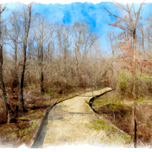
Nature enthusiasts will find plenty to enjoy in this state park. Trails of Tears State Park encompasses approximately 5,000 acres and offers a variety of outdoor activities. Hiking enthusiasts can explore over 10 miles of scenic trails, which wind through lush forests, along serene lakeshores, and up to panoramic overlooks. The park also offers opportunities for fishing, boating, and picnicking, with Lake Boutin being a popular spot for anglers.
The area's wildlife is another attraction of Trails of Tears State Park. Birdwatchers will be thrilled to spot a variety of species, including bald eagles, herons, and numerous migratory birds. White-tailed deer, wild turkeys, squirrels, and raccoons also call this park home, providing ample opportunities for wildlife observation and photography.
Interesting facts about Trails of Tears State Park include its association with the Civilian Conservation Corps (CCC), which was instrumental in developing the park during the Great Depression. Many of the structures found in the park, such as the stone lodge and picnic shelters, were built by the CCC and add to its historical charm.
The best time of year to visit Trails of Tears State Park depends on personal preferences. Spring offers beautiful wildflower displays and the opportunity to spot migratory birds. Summer is ideal for boating and fishing, while autumn showcases vibrant fall foliage. Winter offers a serene experience with fewer visitors and the chance to observe wildlife in their winter habitats.
To ensure accuracy, it is recommended to verify the information provided by cross-referencing multiple independent sources such as the official website of the Illinois Department of Natural Resources, travel guides, and reputable outdoor recreation websites.
Trails in Trails Of Tears State Park
Named trails whose route falls inside the park.
Plan your visit down to the hour
Same weather feed Snoflo's iOS app uses -- updated continuously from NOAA / yr.no.
Next 5 days, hour by hour
Temperature line with weather symbols on top, snow + rain accumulation as columns, humidity as a dotted line.
5-day forecast table
Every 3 hours, broken out across temperature, snow, rain, humidity, and wind.
| Time | Condition | Temp (°F) | Snow (in) | Rain (in) | Humidity (%) | Wind (mps) | Wind dir |
|---|---|---|---|---|---|---|---|
| Loading detailed forecast… | |||||||
15-day temperature & precipitation
Daily temperatures, snow, and rain projected over the next two weeks.
Responsible recreation & Leave No Trace
- Know before you go
- Check the operator's site for hours, permit requirements, seasonal closures, and fire restrictions before heading out.
- Stay on trail
- Stick to marked paths to protect vegetation, prevent erosion, and avoid disturbing wildlife habitat.
- Respect wildlife
- Observe from a distance, never feed wildlife, and store food securely if camping is permitted on-site.
- Pack it in, pack it out
- Carry out all trash, food scraps, and gear. Many parks have limited or no trash service.
- Leave what you find
- Don't take rocks, plants, or artifacts. They make the park what it is for the next visitor.
Set push alerts in the Snoflo app
Save Trails Of Tears State Park as a favorite, set a custom threshold (precipitation, freezing temperatures, fire-restriction days), and the iOS app will push the moment conditions cross.
About Trails Of Tears State Park
What can I do at Trails Of Tears State Park?
Most Snoflo-tracked parks support hiking, picnicking, and wildlife viewing. Check the operator's site for activity-specific rules (camping, fishing, paddling, hunting).
How fresh is the weather data?
The hourly forecast updates throughout the day from NOAA / yr.no. Streamflow comes live from USGS streamgauges.
When is the best time to visit?
Use the 15-day temperature & precipitation outlook on this page to plan -- pick a window with comfortable temperatures and low precipitation.
How do I get to Trails Of Tears State Park?
Tap Directions in the hero above to open driving directions in Google Maps, or Open in map to center the Snoflo interactive map on the park.
Can I get alerts when conditions change?
Yes -- alerts are managed in the Snoflo iOS app. Favorite this park, set a threshold (temperature, precipitation), and you'll get a push the moment it crosses.
Park & land designation reference
A quick legend for the federal and state land categories Snoflo tracks. Each designation comes with different rules around access, recreation, and resource extraction.
- National Park
- Large protected natural areas managed by the federal government to preserve significant landscapes, ecosystems, and cultural resources; recreation is allowed but conservation is the priority.
- State Park
- Public natural or recreational areas managed by a state government, typically smaller than national parks and focused on regional natural features, recreation, and education.
- Local Park
- Community-level parks managed by cities or counties, emphasizing recreation, playgrounds, sports, and green space close to populated areas.
- Wilderness Area
- The highest level of land protection in the U.S.; designated areas where nature is left essentially untouched, with no roads, structures, or motorized motorized access permitted.
- National Recreation Area
- Areas set aside primarily for outdoor recreation (boating, hiking, fishing, often around reservoirs, rivers, or scenic landscapes); may allow more development.
- National Conservation Area (BLM)
- BLM-managed areas with special ecological, cultural, or scientific value; more protection than typical BLM land but less strict than Wilderness Areas.
- State Forest
- State-managed forests focused on habitat, watershed, recreation, and sustainable timber harvest.
- Bureau of Land Management (BLM) Land
- Vast federal lands managed for mixed use -- recreation, grazing, mining, conservation -- with fewer restrictions than national parks or forests.