State Park Hart, Miller And Pleasure Islands
Community Reviews
Been here? Share the conditions.
Reviews, ratings & photos are added in the free Snoflo iOS app — rate a spot, tag the conditions, and your visit is verified by location. Add or manage your reviews from the app.
State Park Hart, Miller And Pleasure Islands
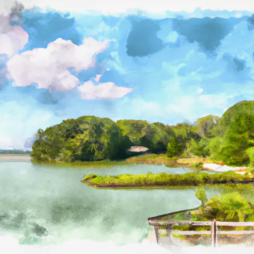
One of the key reasons to visit these islands is the abundance of outdoor activities they offer. Visitors can enjoy swimming, boating, fishing, hiking, and birdwatching, allowing them to immerse themselves in the beauty of the Chesapeake Bay. The islands also feature picnic areas and campgrounds, providing opportunities for relaxation and overnight stays.
State Park Hart, Miller, and Pleasure Islands are home to several points of interest that deserve attention. Hart-Miller Island, for example, boasts a beautiful sandy beach and a historic lighthouse, which offers panoramic views of the bay. Pleasure Island is known for its marshes, where visitors can spot a diverse range of bird species, including herons and ospreys. The islands also have several nature trails, such as the Pleasure Island Nature Trail, offering scenic walks through forests and wetlands.
Some interesting facts about the islands include their historical significance. Hart-Miller Island, for instance, was originally two separate islands that were joined together by the construction of a dike in the 1980s, creating a habitat for wildlife and a recreational area. Additionally, the area is famous for the nesting bald eagles that can be observed on the islands.
The best time of year to visit State Park Hart, Miller, and Pleasure Islands is during the spring and fall seasons. Mild temperatures and fewer crowds make these seasons ideal for outdoor activities and exploring the islands' trails. It is worth noting that some amenities and facilities might have limited availability during the off-peak seasons, so visitors should plan accordingly.
While this summary provides an overview of State Park Hart, Miller, and Pleasure Islands, it is advisable to verify the information across multiple independent sources to ensure accuracy and to account for any changes or updates to the islands' attractions and facilities.
Trails in State Park Hart, Miller And Pleasure Islands
Named trails whose route falls inside the park.
Plan your visit down to the hour
Same weather feed Snoflo's iOS app uses -- updated continuously from NOAA / yr.no.
Next 5 days, hour by hour
Temperature line with weather symbols on top, snow + rain accumulation as columns, humidity as a dotted line.
5-day forecast table
Every 3 hours, broken out across temperature, snow, rain, humidity, and wind.
| Time | Condition | Temp (°F) | Snow (in) | Rain (in) | Humidity (%) | Wind (mps) | Wind dir |
|---|---|---|---|---|---|---|---|
| Loading detailed forecast… | |||||||
15-day temperature & precipitation
Daily temperatures, snow, and rain projected over the next two weeks.
Responsible recreation & Leave No Trace
- Know before you go
- Check the operator's site for hours, permit requirements, seasonal closures, and fire restrictions before heading out.
- Stay on trail
- Stick to marked paths to protect vegetation, prevent erosion, and avoid disturbing wildlife habitat.
- Respect wildlife
- Observe from a distance, never feed wildlife, and store food securely if camping is permitted on-site.
- Pack it in, pack it out
- Carry out all trash, food scraps, and gear. Many parks have limited or no trash service.
- Leave what you find
- Don't take rocks, plants, or artifacts. They make the park what it is for the next visitor.
Set push alerts in the Snoflo app
Save State Park Hart, Miller And Pleasure Islands as a favorite, set a custom threshold (precipitation, freezing temperatures, fire-restriction days), and the iOS app will push the moment conditions cross.
About State Park Hart, Miller And Pleasure Islands
What can I do at State Park Hart, Miller And Pleasure Islands?
Most Snoflo-tracked parks support hiking, picnicking, and wildlife viewing. Check the operator's site for activity-specific rules (camping, fishing, paddling, hunting).
How fresh is the weather data?
The hourly forecast updates throughout the day from NOAA / yr.no. Streamflow comes live from USGS streamgauges.
When is the best time to visit?
Use the 15-day temperature & precipitation outlook on this page to plan -- pick a window with comfortable temperatures and low precipitation.
How do I get to State Park Hart, Miller And Pleasure Islands?
Tap Directions in the hero above to open driving directions in Google Maps, or Open in map to center the Snoflo interactive map on the park.
Can I get alerts when conditions change?
Yes -- alerts are managed in the Snoflo iOS app. Favorite this park, set a threshold (temperature, precipitation), and you'll get a push the moment it crosses.
Park & land designation reference
A quick legend for the federal and state land categories Snoflo tracks. Each designation comes with different rules around access, recreation, and resource extraction.
- National Park
- Large protected natural areas managed by the federal government to preserve significant landscapes, ecosystems, and cultural resources; recreation is allowed but conservation is the priority.
- State Park
- Public natural or recreational areas managed by a state government, typically smaller than national parks and focused on regional natural features, recreation, and education.
- Local Park
- Community-level parks managed by cities or counties, emphasizing recreation, playgrounds, sports, and green space close to populated areas.
- Wilderness Area
- The highest level of land protection in the U.S.; designated areas where nature is left essentially untouched, with no roads, structures, or motorized motorized access permitted.
- National Recreation Area
- Areas set aside primarily for outdoor recreation (boating, hiking, fishing, often around reservoirs, rivers, or scenic landscapes); may allow more development.
- National Conservation Area (BLM)
- BLM-managed areas with special ecological, cultural, or scientific value; more protection than typical BLM land but less strict than Wilderness Areas.
- State Forest
- State-managed forests focused on habitat, watershed, recreation, and sustainable timber harvest.
- Bureau of Land Management (BLM) Land
- Vast federal lands managed for mixed use -- recreation, grazing, mining, conservation -- with fewer restrictions than national parks or forests.