Community Reviews
Been here? Share the conditions.
Reviews, ratings & photos are added in the free Snoflo iOS app — rate a spot, tag the conditions, and your visit is verified by location. Add or manage your reviews from the app.
Rutland State Park
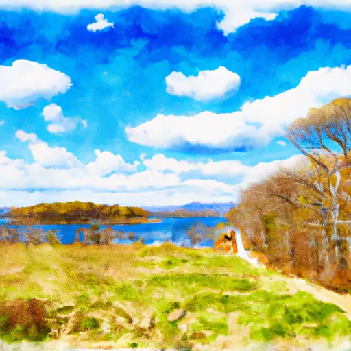
One of the primary reasons to visit Rutland State Park is its breathtaking natural beauty. The park is home to several pristine ponds, including Whitehall Pond, which is the main focal point of the park. These bodies of water provide ample opportunities for swimming, boating, and fishing, making it an ideal spot for water-based activities.
For hikers and nature walkers, Rutland State Park boasts an extensive network of trails that wind through its lush forests and scenic landscapes. The trails vary in difficulty, catering to both beginners and more experienced hikers. Along these trails, visitors can admire the stunning flora and fauna that call the park home.
One of the notable points of interest within the park is the historic Midstate Trail. This long-distance trail spans across Massachusetts, connecting various state parks and offering hikers a chance to explore the diverse landscapes of the region. Rutland State Park serves as a convenient starting or ending point for those embarking on this adventurous journey.
Interesting facts about Rutland State Park include its history as a former industrial site, hosting a woolen mill and later serving as a water source for the city of Worcester. Today, the park stands as a testament to the successful reclamation of industrial lands, showcasing the resilience of nature.
The best time to visit Rutland State Park largely depends on personal preferences and desired activities. During the summer months, the park sees a surge in visitors enjoying water activities, picnicking, and hiking. The fall season offers stunning foliage displays, making it an ideal time for nature walks and photography. Winter opens up opportunities for ice fishing and winter hiking, while spring brings an abundance of wildflowers and renewed greenery.
To ensure accuracy, it is recommended to verify the information provided by consulting multiple independent sources such as the official website of Massachusetts State Parks, travel guides, and reputable online resources dedicated to outdoor activities in Massachusetts.
Plan your visit down to the hour
Same weather feed Snoflo's iOS app uses -- updated continuously from NOAA / yr.no.
Next 5 days, hour by hour
Temperature line with weather symbols on top, snow + rain accumulation as columns, humidity as a dotted line.
5-day forecast table
Every 3 hours, broken out across temperature, snow, rain, humidity, and wind.
| Time | Condition | Temp (°F) | Snow (in) | Rain (in) | Humidity (%) | Wind (mps) | Wind dir |
|---|---|---|---|---|---|---|---|
| Loading detailed forecast… | |||||||
15-day temperature & precipitation
Daily temperatures, snow, and rain projected over the next two weeks.
Responsible recreation & Leave No Trace
- Know before you go
- Check the operator's site for hours, permit requirements, seasonal closures, and fire restrictions before heading out.
- Stay on trail
- Stick to marked paths to protect vegetation, prevent erosion, and avoid disturbing wildlife habitat.
- Respect wildlife
- Observe from a distance, never feed wildlife, and store food securely if camping is permitted on-site.
- Pack it in, pack it out
- Carry out all trash, food scraps, and gear. Many parks have limited or no trash service.
- Leave what you find
- Don't take rocks, plants, or artifacts. They make the park what it is for the next visitor.
Set push alerts in the Snoflo app
Save Rutland State Park as a favorite, set a custom threshold (precipitation, freezing temperatures, fire-restriction days), and the iOS app will push the moment conditions cross.
About Rutland State Park
What can I do at Rutland State Park?
Most Snoflo-tracked parks support hiking, picnicking, and wildlife viewing. Check the operator's site for activity-specific rules (camping, fishing, paddling, hunting).
How fresh is the weather data?
The hourly forecast updates throughout the day from NOAA / yr.no. Streamflow comes live from USGS streamgauges.
When is the best time to visit?
Use the 15-day temperature & precipitation outlook on this page to plan -- pick a window with comfortable temperatures and low precipitation.
How do I get to Rutland State Park?
Tap Directions in the hero above to open driving directions in Google Maps, or Open in map to center the Snoflo interactive map on the park.
Can I get alerts when conditions change?
Yes -- alerts are managed in the Snoflo iOS app. Favorite this park, set a threshold (temperature, precipitation), and you'll get a push the moment it crosses.
Park & land designation reference
A quick legend for the federal and state land categories Snoflo tracks. Each designation comes with different rules around access, recreation, and resource extraction.
- National Park
- Large protected natural areas managed by the federal government to preserve significant landscapes, ecosystems, and cultural resources; recreation is allowed but conservation is the priority.
- State Park
- Public natural or recreational areas managed by a state government, typically smaller than national parks and focused on regional natural features, recreation, and education.
- Local Park
- Community-level parks managed by cities or counties, emphasizing recreation, playgrounds, sports, and green space close to populated areas.
- Wilderness Area
- The highest level of land protection in the U.S.; designated areas where nature is left essentially untouched, with no roads, structures, or motorized motorized access permitted.
- National Recreation Area
- Areas set aside primarily for outdoor recreation (boating, hiking, fishing, often around reservoirs, rivers, or scenic landscapes); may allow more development.
- National Conservation Area (BLM)
- BLM-managed areas with special ecological, cultural, or scientific value; more protection than typical BLM land but less strict than Wilderness Areas.
- State Forest
- State-managed forests focused on habitat, watershed, recreation, and sustainable timber harvest.
- Bureau of Land Management (BLM) Land
- Vast federal lands managed for mixed use -- recreation, grazing, mining, conservation -- with fewer restrictions than national parks or forests.