Community Reviews
Been here? Share the conditions.
Reviews, ratings & photos are added in the free Snoflo iOS app — rate a spot, tag the conditions, and your visit is verified by location. Add or manage your reviews from the app.
Warwick State Forest
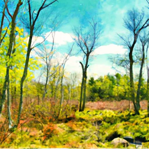
One of the primary reasons to visit Warwick State Forest is its ample opportunities for outdoor recreation. The forest encompasses over 1,000 acres of pristine woodlands, making it a perfect destination for hikers, nature enthusiasts, and adventure seekers. The well-maintained trails cater to all skill levels, allowing visitors to explore the beautiful scenery at their own pace.
Within the forest, there are several notable points of interest worth visiting. The popular Wendell State Forest, which borders Warwick State Forest, offers additional trails, picnic areas, and a beautiful swimming area at Ruggles Pond. This proximity allows visitors to enjoy an extended adventure and experience even more natural beauty.
One of the unique features of Warwick State Forest is its diverse wildlife. The region is home to various species of birds, including the elusive pileated woodpecker, making it a paradise for birdwatchers. Additionally, the forest boasts a range of plant life, from vibrant wildflowers to towering trees, providing excellent opportunities for photography and nature observation.
The best time to visit Warwick State Forest largely depends on personal preferences and desired activities. During the spring and summer, the forest comes alive with lush greenery, blooming wildflowers, and vibrant birdlife. This time of year is ideal for hiking, camping, and enjoying the picturesque views. In autumn, the forest bursts into a kaleidoscope of colors as the leaves change, attracting leaf peepers from far and wide. The crisp air and stunning fall foliage make it a popular season for photography and scenic drives.
To ensure the accuracy of this information, it is recommended to consult multiple independent sources such as official state park websites, travel guides, and reputable outdoor recreation websites.
Trails in Warwick State Forest
Named trails whose route falls inside the park.
Plan your visit down to the hour
Same weather feed Snoflo's iOS app uses -- updated continuously from NOAA / yr.no.
Next 5 days, hour by hour
Temperature line with weather symbols on top, snow + rain accumulation as columns, humidity as a dotted line.
5-day forecast table
Every 3 hours, broken out across temperature, snow, rain, humidity, and wind.
| Time | Condition | Temp (°F) | Snow (in) | Rain (in) | Humidity (%) | Wind (mps) | Wind dir |
|---|---|---|---|---|---|---|---|
| Loading detailed forecast… | |||||||
15-day temperature & precipitation
Daily temperatures, snow, and rain projected over the next two weeks.
Responsible recreation & Leave No Trace
- Know before you go
- Check the operator's site for hours, permit requirements, seasonal closures, and fire restrictions before heading out.
- Stay on trail
- Stick to marked paths to protect vegetation, prevent erosion, and avoid disturbing wildlife habitat.
- Respect wildlife
- Observe from a distance, never feed wildlife, and store food securely if camping is permitted on-site.
- Pack it in, pack it out
- Carry out all trash, food scraps, and gear. Many parks have limited or no trash service.
- Leave what you find
- Don't take rocks, plants, or artifacts. They make the park what it is for the next visitor.
Set push alerts in the Snoflo app
Save Warwick State Forest as a favorite, set a custom threshold (precipitation, freezing temperatures, fire-restriction days), and the iOS app will push the moment conditions cross.
About Warwick State Forest
What can I do at Warwick State Forest?
Most Snoflo-tracked parks support hiking, picnicking, and wildlife viewing. Check the operator's site for activity-specific rules (camping, fishing, paddling, hunting).
How fresh is the weather data?
The hourly forecast updates throughout the day from NOAA / yr.no. Streamflow comes live from USGS streamgauges.
When is the best time to visit?
Use the 15-day temperature & precipitation outlook on this page to plan -- pick a window with comfortable temperatures and low precipitation.
How do I get to Warwick State Forest?
Tap Directions in the hero above to open driving directions in Google Maps, or Open in map to center the Snoflo interactive map on the park.
Can I get alerts when conditions change?
Yes -- alerts are managed in the Snoflo iOS app. Favorite this park, set a threshold (temperature, precipitation), and you'll get a push the moment it crosses.
Park & land designation reference
A quick legend for the federal and state land categories Snoflo tracks. Each designation comes with different rules around access, recreation, and resource extraction.
- National Park
- Large protected natural areas managed by the federal government to preserve significant landscapes, ecosystems, and cultural resources; recreation is allowed but conservation is the priority.
- State Park
- Public natural or recreational areas managed by a state government, typically smaller than national parks and focused on regional natural features, recreation, and education.
- Local Park
- Community-level parks managed by cities or counties, emphasizing recreation, playgrounds, sports, and green space close to populated areas.
- Wilderness Area
- The highest level of land protection in the U.S.; designated areas where nature is left essentially untouched, with no roads, structures, or motorized motorized access permitted.
- National Recreation Area
- Areas set aside primarily for outdoor recreation (boating, hiking, fishing, often around reservoirs, rivers, or scenic landscapes); may allow more development.
- National Conservation Area (BLM)
- BLM-managed areas with special ecological, cultural, or scientific value; more protection than typical BLM land but less strict than Wilderness Areas.
- State Forest
- State-managed forests focused on habitat, watershed, recreation, and sustainable timber harvest.
- Bureau of Land Management (BLM) Land
- Vast federal lands managed for mixed use -- recreation, grazing, mining, conservation -- with fewer restrictions than national parks or forests.