Community Reviews
Been here? Share the conditions.
Reviews, ratings & photos are added in the free Snoflo iOS app — rate a spot, tag the conditions, and your visit is verified by location. Add or manage your reviews from the app.
Samuel R Mckelvie National Forest
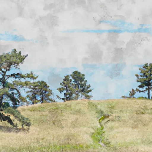
One of the primary reasons to visit Samuel R McKelvie National Forest is its unparalleled beauty. The vast expanses of grasslands, dotted with small ponds and lakes, create a serene and peaceful atmosphere. The Sandhills region itself is a geological marvel, consisting of grass-covered sand dunes that are the largest of their kind in the Western Hemisphere. These rolling sandhills provide a mesmerizing backdrop for outdoor enthusiasts and nature lovers alike.
The national forest offers numerous recreational activities for visitors to enjoy. Fishing is a popular pastime, with several lakes and ponds providing opportunities to catch various species of fish, including largemouth bass, crappie, and bluegill. Boating and kayaking are also available on some lakes. Hunting enthusiasts can explore the forest during the designated seasons for deer, turkey, pheasant, and quail.
For those interested in wildlife, Samuel R McKelvie National Forest is home to a diverse range of species. Birdwatchers will be delighted to spot an array of migratory birds, including sandhill cranes, whooping cranes, and waterfowl. The forest is also home to mule deer, white-tailed deer, bobcats, coyotes, and numerous small mammals.
Interesting facts about Samuel R McKelvie National Forest include its status as the only national forest in Nebraska and its unique topography shaped by glaciers and wind over thousands of years. The forest's varied landscapes support a rich biodiversity, making it an important habitat for various plant and animal species.
The best time to visit Samuel R McKelvie National Forest is during the spring and fall seasons. Spring brings vibrant wildflowers blooming across the grasslands, while fall showcases the beautiful changing colors of the foliage. Summers can be hot and dry, and winters are typically cold with occasional snowfall.
To ensure accuracy, it is advisable to verify this information across multiple independent sources, such as the official website of Samuel R McKelvie National Forest, the U.S. Forest Service, and reputable travel guides or tourism websites.
Plan your visit down to the hour
Same weather feed Snoflo's iOS app uses -- updated continuously from NOAA / yr.no.
Next 5 days, hour by hour
Temperature line with weather symbols on top, snow + rain accumulation as columns, humidity as a dotted line.
5-day forecast table
Every 3 hours, broken out across temperature, snow, rain, humidity, and wind.
| Time | Condition | Temp (°F) | Snow (in) | Rain (in) | Humidity (%) | Wind (mps) | Wind dir |
|---|---|---|---|---|---|---|---|
| Loading detailed forecast… | |||||||
15-day temperature & precipitation
Daily temperatures, snow, and rain projected over the next two weeks.
Responsible recreation & Leave No Trace
- Know before you go
- Check the operator's site for hours, permit requirements, seasonal closures, and fire restrictions before heading out.
- Stay on trail
- Stick to marked paths to protect vegetation, prevent erosion, and avoid disturbing wildlife habitat.
- Respect wildlife
- Observe from a distance, never feed wildlife, and store food securely if camping is permitted on-site.
- Pack it in, pack it out
- Carry out all trash, food scraps, and gear. Many parks have limited or no trash service.
- Leave what you find
- Don't take rocks, plants, or artifacts. They make the park what it is for the next visitor.
Set push alerts in the Snoflo app
Save Samuel R Mckelvie National Forest as a favorite, set a custom threshold (precipitation, freezing temperatures, fire-restriction days), and the iOS app will push the moment conditions cross.
About Samuel R Mckelvie National Forest
What can I do at Samuel R Mckelvie National Forest?
Most Snoflo-tracked parks support hiking, picnicking, and wildlife viewing. Check the operator's site for activity-specific rules (camping, fishing, paddling, hunting).
How fresh is the weather data?
The hourly forecast updates throughout the day from NOAA / yr.no. Streamflow comes live from USGS streamgauges.
When is the best time to visit?
Use the 15-day temperature & precipitation outlook on this page to plan -- pick a window with comfortable temperatures and low precipitation.
How do I get to Samuel R Mckelvie National Forest?
Tap Directions in the hero above to open driving directions in Google Maps, or Open in map to center the Snoflo interactive map on the park.
Can I get alerts when conditions change?
Yes -- alerts are managed in the Snoflo iOS app. Favorite this park, set a threshold (temperature, precipitation), and you'll get a push the moment it crosses.
Park & land designation reference
A quick legend for the federal and state land categories Snoflo tracks. Each designation comes with different rules around access, recreation, and resource extraction.
- National Park
- Large protected natural areas managed by the federal government to preserve significant landscapes, ecosystems, and cultural resources; recreation is allowed but conservation is the priority.
- State Park
- Public natural or recreational areas managed by a state government, typically smaller than national parks and focused on regional natural features, recreation, and education.
- Local Park
- Community-level parks managed by cities or counties, emphasizing recreation, playgrounds, sports, and green space close to populated areas.
- Wilderness Area
- The highest level of land protection in the U.S.; designated areas where nature is left essentially untouched, with no roads, structures, or motorized motorized access permitted.
- National Recreation Area
- Areas set aside primarily for outdoor recreation (boating, hiking, fishing, often around reservoirs, rivers, or scenic landscapes); may allow more development.
- National Conservation Area (BLM)
- BLM-managed areas with special ecological, cultural, or scientific value; more protection than typical BLM land but less strict than Wilderness Areas.
- State Forest
- State-managed forests focused on habitat, watershed, recreation, and sustainable timber harvest.
- Bureau of Land Management (BLM) Land
- Vast federal lands managed for mixed use -- recreation, grazing, mining, conservation -- with fewer restrictions than national parks or forests.