Community Reviews
Been here? Share the conditions.
Reviews, ratings & photos are added in the free Snoflo iOS app — rate a spot, tag the conditions, and your visit is verified by location. Add or manage your reviews from the app.
Tewaukon National Wildlife Refuge
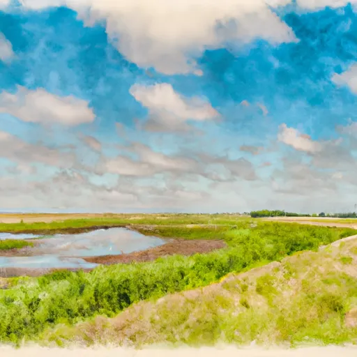
Located near the town of Cayuga, Tewaukon National Wildlife Refuge spans over 8,500 acres, encompassing wetlands, grasslands, and woodlands. It serves as an important stopover for migratory birds and provides a crucial habitat for various wildlife species.
Reasons to visit Tewaukon National Wildlife Refuge are plentiful. Birdwatching is a popular activity, as the refuge boasts over 230 bird species, including rare and endangered species such as the whooping crane. Several observation platforms are strategically positioned throughout the refuge, providing excellent vantage points for viewing the abundant birdlife.
Nature trails wind through the refuge, offering visitors the opportunity to explore the diverse ecosystems and observe the native flora and fauna. The refuge is home to white-tailed deer, moose, beavers, coyotes, and numerous smaller mammals, making wildlife viewing a rewarding experience.
One of the main points of interest within the refuge is Lake Tewaukon, a 2,200-acre lake that attracts fishing enthusiasts. The lake is known for its healthy populations of walleye, northern pike, and yellow perch, providing ample opportunities for anglers. Boating and kayaking are also popular activities on the lake.
In addition to its natural beauty, Tewaukon National Wildlife Refuge also holds historical significance. The refuge lies within the historic Dakota Territory, and remnants of old settlements and homesteads can still be found within its boundaries. Exploring these cultural artifacts offers visitors a glimpse into the area's past.
Interesting facts about Tewaukon National Wildlife Refuge include its role in preserving and restoring native prairie habitats. The refuge actively manages its grasslands to maintain their ecological integrity and prevent encroachment by non-native species. This conservation effort contributes to the overall health and biodiversity of the region.
The best time to visit Tewaukon National Wildlife Refuge depends on personal preferences. Spring and fall are popular seasons for birdwatching due to the abundance of migratory species. During the summer, wildflowers bloom, and the refuge is alive with the sounds of insects and birds. Winter brings a different charm, as visitors can witness the refuge covered in a pristine blanket of snow, offering opportunities for snowshoeing and cross-country skiing.
Overall, Tewaukon National Wildlife Refuge in North Dakota is a remarkable destination for nature lovers, offering an array of activities, diverse wildlife, historical significance, and beautiful landscapes throughout the year.
Streamflow in Tewaukon National Wildlife Refuge
Live USGS discharge at streamgauges inside the park boundary.
Plan your visit down to the hour
Same weather feed Snoflo's iOS app uses -- updated continuously from NOAA / yr.no.
Next 5 days, hour by hour
Temperature line with weather symbols on top, snow + rain accumulation as columns, humidity as a dotted line.
5-day forecast table
Every 3 hours, broken out across temperature, snow, rain, humidity, and wind.
| Time | Condition | Temp (°F) | Snow (in) | Rain (in) | Humidity (%) | Wind (mps) | Wind dir |
|---|---|---|---|---|---|---|---|
| Loading detailed forecast… | |||||||
15-day temperature & precipitation
Daily temperatures, snow, and rain projected over the next two weeks.
Responsible recreation & Leave No Trace
- Know before you go
- Check the operator's site for hours, permit requirements, seasonal closures, and fire restrictions before heading out.
- Stay on trail
- Stick to marked paths to protect vegetation, prevent erosion, and avoid disturbing wildlife habitat.
- Respect wildlife
- Observe from a distance, never feed wildlife, and store food securely if camping is permitted on-site.
- Pack it in, pack it out
- Carry out all trash, food scraps, and gear. Many parks have limited or no trash service.
- Leave what you find
- Don't take rocks, plants, or artifacts. They make the park what it is for the next visitor.
Set push alerts in the Snoflo app
Save Tewaukon National Wildlife Refuge as a favorite, set a custom threshold (precipitation, freezing temperatures, fire-restriction days), and the iOS app will push the moment conditions cross.
About Tewaukon National Wildlife Refuge
What can I do at Tewaukon National Wildlife Refuge?
Most Snoflo-tracked parks support hiking, picnicking, and wildlife viewing. Check the operator's site for activity-specific rules (camping, fishing, paddling, hunting).
How fresh is the weather data?
The hourly forecast updates throughout the day from NOAA / yr.no. Streamflow comes live from USGS streamgauges.
When is the best time to visit?
Use the 15-day temperature & precipitation outlook on this page to plan -- pick a window with comfortable temperatures and low precipitation.
How do I get to Tewaukon National Wildlife Refuge?
Tap Directions in the hero above to open driving directions in Google Maps, or Open in map to center the Snoflo interactive map on the park.
Can I get alerts when conditions change?
Yes -- alerts are managed in the Snoflo iOS app. Favorite this park, set a threshold (temperature, precipitation), and you'll get a push the moment it crosses.
Park & land designation reference
A quick legend for the federal and state land categories Snoflo tracks. Each designation comes with different rules around access, recreation, and resource extraction.
- National Park
- Large protected natural areas managed by the federal government to preserve significant landscapes, ecosystems, and cultural resources; recreation is allowed but conservation is the priority.
- State Park
- Public natural or recreational areas managed by a state government, typically smaller than national parks and focused on regional natural features, recreation, and education.
- Local Park
- Community-level parks managed by cities or counties, emphasizing recreation, playgrounds, sports, and green space close to populated areas.
- Wilderness Area
- The highest level of land protection in the U.S.; designated areas where nature is left essentially untouched, with no roads, structures, or motorized motorized access permitted.
- National Recreation Area
- Areas set aside primarily for outdoor recreation (boating, hiking, fishing, often around reservoirs, rivers, or scenic landscapes); may allow more development.
- National Conservation Area (BLM)
- BLM-managed areas with special ecological, cultural, or scientific value; more protection than typical BLM land but less strict than Wilderness Areas.
- State Forest
- State-managed forests focused on habitat, watershed, recreation, and sustainable timber harvest.
- Bureau of Land Management (BLM) Land
- Vast federal lands managed for mixed use -- recreation, grazing, mining, conservation -- with fewer restrictions than national parks or forests.