Umatilla National Wildlife Refuge
Community Reviews
Been here? Share the conditions.
Reviews, ratings & photos are added in the free Snoflo iOS app — rate a spot, tag the conditions, and your visit is verified by location. Add or manage your reviews from the app.
Umatilla National Wildlife Refuge
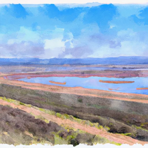
Situated along the Columbia River, the Umatilla National Wildlife Refuge spans approximately 44,500 acres and was established in 1969 to provide habitat for migratory birds, native wildlife species, and endangered species. The refuge is managed by the U.S. Fish and Wildlife Service.
Reasons to Visit:
1. Birdwatching: Umatilla National Wildlife Refuge is a haven for birdwatching, with over 200 bird species recorded, including sandhill cranes, ducks, geese, swans, and various raptors. The refuge provides essential nesting, feeding, and resting areas for migratory birds.
2. Wildlife Viewing: The refuge is home to several mammal species, such as mule deer, coyotes, river otters, beavers, and raccoons. Visitors may also spot reptiles, amphibians, and a variety of fish species.
3. Scenic Landscapes: Umatilla's diverse habitats include wetlands, grasslands, shrub-steppe, and riparian areas, offering picturesque landscapes and scenic views.
4. Outdoor Recreation: The refuge provides opportunities for hiking, wildlife photography, fishing, hunting, and boating (limited access). Several trails are available, including a boardwalk trail, allowing visitors to explore the area's natural beauty.
Points of Interest:
1. McNary Wildlife Nature Trail: This 1.5-mile boardwalk trail allows visitors to explore wetland habitats, observe wildlife, and experience the beauty of the area up close.
2. Headquarters Pond: A popular spot for birdwatching, Headquarters Pond hosts a diverse array of waterfowl and shorebirds.
3. River S Unit: Located in the southeast part of the refuge, the River S Unit offers unique opportunities for wildlife observation and photography.
Interesting Facts:
1. The refuge is an important stopover for migratory birds along the Pacific Flyway, with species traveling from as far as the Arctic to South America.
2. Umatilla National Wildlife Refuge is home to one of the largest wintering populations of mule deer in eastern Oregon.
3. The refuge is actively involved in restoring and enhancing native habitats, including restoring wetlands, improving river channels, and managing invasive species.
Best Time to Visit:
The best time to visit Umatilla National Wildlife Refuge largely depends on personal interests. Spring and fall are ideal for birdwatching, as migratory birds pass through the area. Spring offers breeding displays and nesting activities, while fall brings large flocks of waterfowl. Winter is excellent for observing mule deer and other wildlife. Summer may be hot, but it offers opportunities for hiking and exploring the refuge's landscapes.
To ensure accuracy, it is recommended to consult the official website of Umatilla National Wildlife Refuge and additional reputable sources for the most up-to-date information and specific details.
Trails in Umatilla National Wildlife Refuge
Named trails whose route falls inside the park.
Plan your visit down to the hour
Same weather feed Snoflo's iOS app uses -- updated continuously from NOAA / yr.no.
Next 5 days, hour by hour
Temperature line with weather symbols on top, snow + rain accumulation as columns, humidity as a dotted line.
5-day forecast table
Every 3 hours, broken out across temperature, snow, rain, humidity, and wind.
| Time | Condition | Temp (°F) | Snow (in) | Rain (in) | Humidity (%) | Wind (mps) | Wind dir |
|---|---|---|---|---|---|---|---|
| Loading detailed forecast… | |||||||
15-day temperature & precipitation
Daily temperatures, snow, and rain projected over the next two weeks.
Responsible recreation & Leave No Trace
- Know before you go
- Check the operator's site for hours, permit requirements, seasonal closures, and fire restrictions before heading out.
- Stay on trail
- Stick to marked paths to protect vegetation, prevent erosion, and avoid disturbing wildlife habitat.
- Respect wildlife
- Observe from a distance, never feed wildlife, and store food securely if camping is permitted on-site.
- Pack it in, pack it out
- Carry out all trash, food scraps, and gear. Many parks have limited or no trash service.
- Leave what you find
- Don't take rocks, plants, or artifacts. They make the park what it is for the next visitor.
Set push alerts in the Snoflo app
Save Umatilla National Wildlife Refuge as a favorite, set a custom threshold (precipitation, freezing temperatures, fire-restriction days), and the iOS app will push the moment conditions cross.
About Umatilla National Wildlife Refuge
What can I do at Umatilla National Wildlife Refuge?
Most Snoflo-tracked parks support hiking, picnicking, and wildlife viewing. Check the operator's site for activity-specific rules (camping, fishing, paddling, hunting).
How fresh is the weather data?
The hourly forecast updates throughout the day from NOAA / yr.no. Streamflow comes live from USGS streamgauges.
When is the best time to visit?
Use the 15-day temperature & precipitation outlook on this page to plan -- pick a window with comfortable temperatures and low precipitation.
How do I get to Umatilla National Wildlife Refuge?
Tap Directions in the hero above to open driving directions in Google Maps, or Open in map to center the Snoflo interactive map on the park.
Can I get alerts when conditions change?
Yes -- alerts are managed in the Snoflo iOS app. Favorite this park, set a threshold (temperature, precipitation), and you'll get a push the moment it crosses.
Park & land designation reference
A quick legend for the federal and state land categories Snoflo tracks. Each designation comes with different rules around access, recreation, and resource extraction.
- National Park
- Large protected natural areas managed by the federal government to preserve significant landscapes, ecosystems, and cultural resources; recreation is allowed but conservation is the priority.
- State Park
- Public natural or recreational areas managed by a state government, typically smaller than national parks and focused on regional natural features, recreation, and education.
- Local Park
- Community-level parks managed by cities or counties, emphasizing recreation, playgrounds, sports, and green space close to populated areas.
- Wilderness Area
- The highest level of land protection in the U.S.; designated areas where nature is left essentially untouched, with no roads, structures, or motorized motorized access permitted.
- National Recreation Area
- Areas set aside primarily for outdoor recreation (boating, hiking, fishing, often around reservoirs, rivers, or scenic landscapes); may allow more development.
- National Conservation Area (BLM)
- BLM-managed areas with special ecological, cultural, or scientific value; more protection than typical BLM land but less strict than Wilderness Areas.
- State Forest
- State-managed forests focused on habitat, watershed, recreation, and sustainable timber harvest.
- Bureau of Land Management (BLM) Land
- Vast federal lands managed for mixed use -- recreation, grazing, mining, conservation -- with fewer restrictions than national parks or forests.