Yaquina Bay State Recreation Site
Community Reviews
Been here? Share the conditions.
Reviews, ratings & photos are added in the free Snoflo iOS app — rate a spot, tag the conditions, and your visit is verified by location. Add or manage your reviews from the app.
Yaquina Bay State Recreation Site
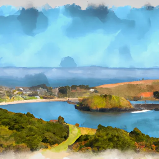
One of the main reasons to visit Yaquina Bay State Recreation Site is its stunning natural beauty. The site is situated along the scenic Yaquina Bay, where visitors can enjoy panoramic views of the bay, the iconic Yaquina Bay Bridge, and the surrounding coastline. The park's sandy beach is perfect for leisurely walks, picnics, or simply enjoying the serene atmosphere.
One of the main points of interest at Yaquina Bay State Recreation Site is the Yaquina Bay Lighthouse. Built in 1871, it is the only existing wooden lighthouse in Oregon. Visitors can explore the lighthouse, learn about its history, and even climb to the top for a magnificent view of the bay.
Another notable feature of the park is the interpretive displays and informational panels that provide insights into the local marine and bird life. Yaquina Bay is home to a diverse range of bird species, making it a popular spot for birdwatching. Additionally, the park offers opportunities for fishing, crabbing, and boating, adding to the recreational options available.
Interesting facts about Yaquina Bay State Recreation Site include its historical significance as a trading and fishing hub dating back to Native American tribes and early European settlers. The park's location near the mouth of the Yaquina River also played a vital role in the region's maritime history.
The best time to visit Yaquina Bay State Recreation Site is during the summer months, from June to September, when the weather is generally sunny and mild. This time of year offers the best conditions for exploring the beach, picnicking, and engaging in outdoor activities. However, it's worth noting that the park can get crowded during peak tourist seasons, so visiting during the weekdays or offseason may provide a more peaceful experience.
To ensure accuracy, it is recommended to verify the information provided by referring to multiple independent sources, such as official park websites, travel guides, and local tourism agencies.
Trails in Yaquina Bay State Recreation Site
Named trails whose route falls inside the park.
Points of interest in Yaquina Bay State Recreation Site
Landmarks and points of interest inside the park boundary.

Plan your visit down to the hour
Same weather feed Snoflo's iOS app uses -- updated continuously from NOAA / yr.no.
Next 5 days, hour by hour
Temperature line with weather symbols on top, snow + rain accumulation as columns, humidity as a dotted line.
5-day forecast table
Every 3 hours, broken out across temperature, snow, rain, humidity, and wind.
| Time | Condition | Temp (°F) | Snow (in) | Rain (in) | Humidity (%) | Wind (mps) | Wind dir |
|---|---|---|---|---|---|---|---|
| Loading detailed forecast… | |||||||
15-day temperature & precipitation
Daily temperatures, snow, and rain projected over the next two weeks.
Responsible recreation & Leave No Trace
- Know before you go
- Check the operator's site for hours, permit requirements, seasonal closures, and fire restrictions before heading out.
- Stay on trail
- Stick to marked paths to protect vegetation, prevent erosion, and avoid disturbing wildlife habitat.
- Respect wildlife
- Observe from a distance, never feed wildlife, and store food securely if camping is permitted on-site.
- Pack it in, pack it out
- Carry out all trash, food scraps, and gear. Many parks have limited or no trash service.
- Leave what you find
- Don't take rocks, plants, or artifacts. They make the park what it is for the next visitor.
Set push alerts in the Snoflo app
Save Yaquina Bay State Recreation Site as a favorite, set a custom threshold (precipitation, freezing temperatures, fire-restriction days), and the iOS app will push the moment conditions cross.
About Yaquina Bay State Recreation Site
What can I do at Yaquina Bay State Recreation Site?
Most Snoflo-tracked parks support hiking, picnicking, and wildlife viewing. Check the operator's site for activity-specific rules (camping, fishing, paddling, hunting).
How fresh is the weather data?
The hourly forecast updates throughout the day from NOAA / yr.no. Streamflow comes live from USGS streamgauges.
When is the best time to visit?
Use the 15-day temperature & precipitation outlook on this page to plan -- pick a window with comfortable temperatures and low precipitation.
How do I get to Yaquina Bay State Recreation Site?
Tap Directions in the hero above to open driving directions in Google Maps, or Open in map to center the Snoflo interactive map on the park.
Can I get alerts when conditions change?
Yes -- alerts are managed in the Snoflo iOS app. Favorite this park, set a threshold (temperature, precipitation), and you'll get a push the moment it crosses.
Park & land designation reference
A quick legend for the federal and state land categories Snoflo tracks. Each designation comes with different rules around access, recreation, and resource extraction.
- National Park
- Large protected natural areas managed by the federal government to preserve significant landscapes, ecosystems, and cultural resources; recreation is allowed but conservation is the priority.
- State Park
- Public natural or recreational areas managed by a state government, typically smaller than national parks and focused on regional natural features, recreation, and education.
- Local Park
- Community-level parks managed by cities or counties, emphasizing recreation, playgrounds, sports, and green space close to populated areas.
- Wilderness Area
- The highest level of land protection in the U.S.; designated areas where nature is left essentially untouched, with no roads, structures, or motorized motorized access permitted.
- National Recreation Area
- Areas set aside primarily for outdoor recreation (boating, hiking, fishing, often around reservoirs, rivers, or scenic landscapes); may allow more development.
- National Conservation Area (BLM)
- BLM-managed areas with special ecological, cultural, or scientific value; more protection than typical BLM land but less strict than Wilderness Areas.
- State Forest
- State-managed forests focused on habitat, watershed, recreation, and sustainable timber harvest.
- Bureau of Land Management (BLM) Land
- Vast federal lands managed for mixed use -- recreation, grazing, mining, conservation -- with fewer restrictions than national parks or forests.