State Park Jones Gap
Community Reviews
Been here? Share the conditions.
Reviews, ratings & photos are added in the free Snoflo iOS app — rate a spot, tag the conditions, and your visit is verified by location. Add or manage your reviews from the app.
State Park Jones Gap
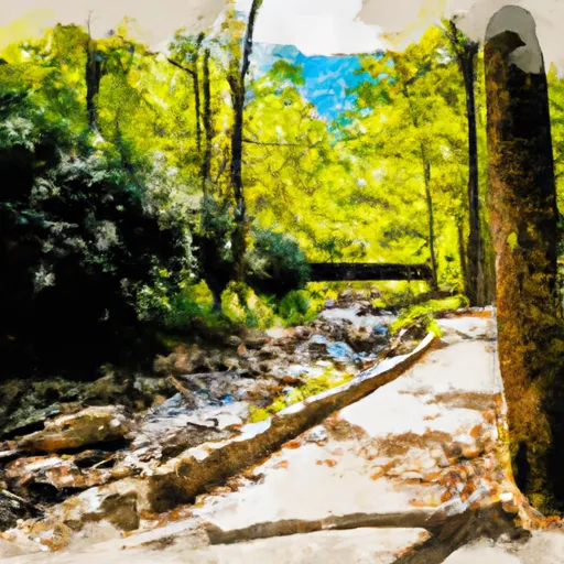
One of the main attractions of Jones Gap State Park is its stunning mountain landscapes. The park is situated within the Blue Ridge Mountains, providing visitors with picturesque views of waterfalls, rugged terrain, and lush forests. The sparkling waters of the Middle Saluda River, which flows through the park, further enhance its charm.
The park offers several points of interest that are worth exploring. Rainbow Falls is a standout feature, boasting a 100-foot cascade that creates a mesmerizing spectacle. The trail leading to the falls offers a moderate hike, allowing visitors to immerse themselves in the surrounding wilderness. Additionally, Jones Gap State Park encompasses over 30 miles of hiking trails, varying in difficulty and catering to both novice and experienced hikers. These trails offer opportunities to discover hidden waterfalls, observe wildlife, and experience the tranquility of nature.
Jones Gap State Park is home to a rich array of wildlife, including various bird species, reptiles, amphibians, and mammals. Nature enthusiasts can expect to spot the elusive black bear, white-tailed deer, and even the endangered green salamander within the park's boundaries.
Interesting facts about the park include its status as part of the Mountain Bridge Wilderness Area, which is home to the largest collection of rare and endangered plants in the state. Furthermore, Jones Gap State Park's Middle Saluda River is recognized as South Carolina's first designated scenic river, highlighting the area's significance in terms of natural conservation.
The best time to visit Jones Gap State Park largely depends on personal preferences and desired activities. Spring offers beautiful blooms and mild temperatures, making it an ideal season for hiking and wildlife spotting. Summer invites visitors to enjoy swimming and picnicking near the river, although it can be crowded during this time. Fall is highly recommended due to the vibrant foliage, creating a picturesque backdrop for hiking and photography. Winter, although colder, presents a unique charm with the possibility of snowfall and solitude within the park.
It is crucial to verify the accuracy of this information by consulting multiple independent sources, such as the official South Carolina State Parks website, park brochures, and reputable travel guides.
Trails in State Park Jones Gap
Named trails whose route falls inside the park.
Points of interest in State Park Jones Gap
Landmarks and points of interest inside the park boundary.

Plan your visit down to the hour
Same weather feed Snoflo's iOS app uses -- updated continuously from NOAA / yr.no.
Next 5 days, hour by hour
Temperature line with weather symbols on top, snow + rain accumulation as columns, humidity as a dotted line.
5-day forecast table
Every 3 hours, broken out across temperature, snow, rain, humidity, and wind.
| Time | Condition | Temp (°F) | Snow (in) | Rain (in) | Humidity (%) | Wind (mps) | Wind dir |
|---|---|---|---|---|---|---|---|
| Loading detailed forecast… | |||||||
15-day temperature & precipitation
Daily temperatures, snow, and rain projected over the next two weeks.
Responsible recreation & Leave No Trace
- Know before you go
- Check the operator's site for hours, permit requirements, seasonal closures, and fire restrictions before heading out.
- Stay on trail
- Stick to marked paths to protect vegetation, prevent erosion, and avoid disturbing wildlife habitat.
- Respect wildlife
- Observe from a distance, never feed wildlife, and store food securely if camping is permitted on-site.
- Pack it in, pack it out
- Carry out all trash, food scraps, and gear. Many parks have limited or no trash service.
- Leave what you find
- Don't take rocks, plants, or artifacts. They make the park what it is for the next visitor.
Set push alerts in the Snoflo app
Save State Park Jones Gap as a favorite, set a custom threshold (precipitation, freezing temperatures, fire-restriction days), and the iOS app will push the moment conditions cross.
About State Park Jones Gap
What can I do at State Park Jones Gap?
Most Snoflo-tracked parks support hiking, picnicking, and wildlife viewing. Check the operator's site for activity-specific rules (camping, fishing, paddling, hunting).
How fresh is the weather data?
The hourly forecast updates throughout the day from NOAA / yr.no. Streamflow comes live from USGS streamgauges.
When is the best time to visit?
Use the 15-day temperature & precipitation outlook on this page to plan -- pick a window with comfortable temperatures and low precipitation.
How do I get to State Park Jones Gap?
Tap Directions in the hero above to open driving directions in Google Maps, or Open in map to center the Snoflo interactive map on the park.
Can I get alerts when conditions change?
Yes -- alerts are managed in the Snoflo iOS app. Favorite this park, set a threshold (temperature, precipitation), and you'll get a push the moment it crosses.
Park & land designation reference
A quick legend for the federal and state land categories Snoflo tracks. Each designation comes with different rules around access, recreation, and resource extraction.
- National Park
- Large protected natural areas managed by the federal government to preserve significant landscapes, ecosystems, and cultural resources; recreation is allowed but conservation is the priority.
- State Park
- Public natural or recreational areas managed by a state government, typically smaller than national parks and focused on regional natural features, recreation, and education.
- Local Park
- Community-level parks managed by cities or counties, emphasizing recreation, playgrounds, sports, and green space close to populated areas.
- Wilderness Area
- The highest level of land protection in the U.S.; designated areas where nature is left essentially untouched, with no roads, structures, or motorized motorized access permitted.
- National Recreation Area
- Areas set aside primarily for outdoor recreation (boating, hiking, fishing, often around reservoirs, rivers, or scenic landscapes); may allow more development.
- National Conservation Area (BLM)
- BLM-managed areas with special ecological, cultural, or scientific value; more protection than typical BLM land but less strict than Wilderness Areas.
- State Forest
- State-managed forests focused on habitat, watershed, recreation, and sustainable timber harvest.
- Bureau of Land Management (BLM) Land
- Vast federal lands managed for mixed use -- recreation, grazing, mining, conservation -- with fewer restrictions than national parks or forests.