
Frost Dam Reservoir Report
Nearby: Thiltgas Gerweck Dam Snethen Dam 5235
Last Updated: January 11, 2026
Frost Dam, located in Rulo, Nebraska, is a vital structure managed by the local government for flood risk reduction and other purposes.
°F
°F
mph
Wind
%
Humidity
Summary
Built in 1980, this earth dam stands at a height of 36 feet and has a storage capacity of 132 acre-feet. Situated on the TR-CANADA CREEK, Frost Dam plays a crucial role in managing water resources in the region, with a drainage area of 0.7 square miles and a maximum discharge capacity of 291 cubic feet per second.
Despite its importance, Frost Dam is currently in poor condition, as indicated by a 2016 inspection report. The dam has a low hazard potential but requires attention to improve its structural integrity. The Nebraska Department of Natural Resources oversees the regulatory aspects of the dam, including permitting, inspection, and enforcement. The dam's emergency action plan and risk assessment measures are currently not up to date, highlighting the need for proactive maintenance and management strategies to ensure the safety and functionality of this key water resource infrastructure.
With its stone core and soil foundation, Frost Dam serves as a critical tool for water resource management in Richardson County, Nebraska. As climate change continues to impact precipitation patterns and increase the frequency of extreme weather events, the proper maintenance and operation of dams like Frost Dam are essential for mitigating flood risks and ensuring the long-term sustainability of water resources in the region.
Year Completed |
1980 |
Dam Length |
179 |
Dam Height |
36 |
River Or Stream |
TR-CANADA CREEK |
Primary Dam Type |
Earth |
Surface Area |
5 |
Hydraulic Height |
35 |
Drainage Area |
0.7 |
Nid Storage |
132 |
Structural Height |
41 |
Hazard Potential |
Low |
Foundations |
Soil |
Nid Height |
41 |
Seasonal Comparison
Weather Forecast
Nearby Streamflow Levels
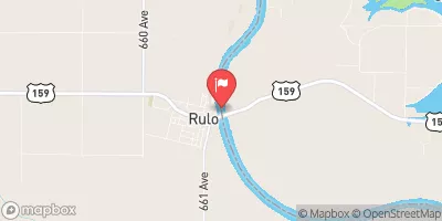 Missouri River At Rulo
|
27400cfs |
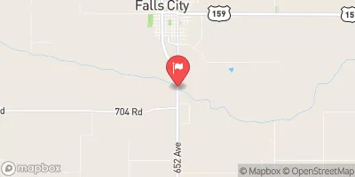 Big Nemaha River At Falls City
|
388cfs |
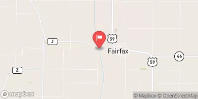 Tarkio River At Fairfax Mo
|
62cfs |
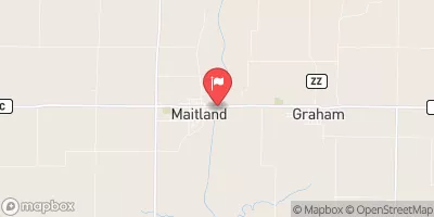 Nodaway River Near Graham
|
92cfs |
 North Fork Big Nemaha River At Humboldt
|
85cfs |
 Little Nemaha River At Auburn
|
134cfs |
Dam Data Reference
Condition Assessment
SatisfactoryNo existing or potential dam safety deficiencies are recognized. Acceptable performance is expected under all loading conditions (static, hydrologic, seismic) in accordance with the minimum applicable state or federal regulatory criteria or tolerable risk guidelines.
Fair
No existing dam safety deficiencies are recognized for normal operating conditions. Rare or extreme hydrologic and/or seismic events may result in a dam safety deficiency. Risk may be in the range to take further action. Note: Rare or extreme event is defined by the regulatory agency based on their minimum
Poor A dam safety deficiency is recognized for normal operating conditions which may realistically occur. Remedial action is necessary. POOR may also be used when uncertainties exist as to critical analysis parameters which identify a potential dam safety deficiency. Investigations and studies are necessary.
Unsatisfactory
A dam safety deficiency is recognized that requires immediate or emergency remedial action for problem resolution.
Not Rated
The dam has not been inspected, is not under state or federal jurisdiction, or has been inspected but, for whatever reason, has not been rated.
Not Available
Dams for which the condition assessment is restricted to approved government users.
Hazard Potential Classification
HighDams assigned the high hazard potential classification are those where failure or mis-operation will probably cause loss of human life.
Significant
Dams assigned the significant hazard potential classification are those dams where failure or mis-operation results in no probable loss of human life but can cause economic loss, environment damage, disruption of lifeline facilities, or impact other concerns. Significant hazard potential classification dams are often located in predominantly rural or agricultural areas but could be in areas with population and significant infrastructure.
Low
Dams assigned the low hazard potential classification are those where failure or mis-operation results in no probable loss of human life and low economic and/or environmental losses. Losses are principally limited to the owner's property.
Undetermined
Dams for which a downstream hazard potential has not been designated or is not provided.
Not Available
Dams for which the downstream hazard potential is restricted to approved government users.
 Frost Dam