
Grassy Creek Watershed Dam G- 92 Reservoir Report
Last Updated: March 4, 2026
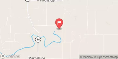
Grassy Creek Watershed Dam G-92, located in Lewis County, Missouri, was completed in 2007 by the USDA NRCS for the primary purpose of flood risk reduction along the Grassy Creek.
Summary
This earth dam stands at a height of 25.4 feet and has a hydraulic height of 25 feet, with a storage capacity of 114.6 acre-feet and a normal storage of 33.8 acre-feet. With a low hazard potential and a moderate risk assessment rating of 3, this dam serves as a vital infrastructure for the local community in Durham.
The dam features an uncontrolled spillway with a width of 30 feet and is managed by the local government as the primary owner. Despite not being state-regulated or inspected, the dam is designed to withstand potential flood events and protect downstream areas from excessive water discharge. The surrounding area covers a drainage area of 172.8 square miles, with a surface area of 3 acres and a maximum discharge capability of 4.2 cubic feet per second.
Grassy Creek Watershed Dam G-92 represents a key component in the flood risk reduction strategy for the region, providing essential protection against potential water overflow and contributing to the overall water resource management efforts. As a notable feature in the local landscape, this dam serves as a testament to the collaborative efforts between the USDA NRCS, the local government, and other stakeholders in safeguarding the community against the impacts of extreme weather events.
°F
°F
mph
Wind
%
Humidity
15-Day Weather Outlook
Year Completed |
2007 |
Dam Length |
520 |
Dam Height |
25.4 |
River Or Stream |
GRASSY CREEK |
Primary Dam Type |
Earth |
Surface Area |
3 |
Hydraulic Height |
25 |
Drainage Area |
172.8 |
Nid Storage |
114.6 |
Structural Height |
30 |
Outlet Gates |
Uncontrolled |
Hazard Potential |
Low |
Foundations |
Soil |
Nid Height |
30 |
Seasonal Comparison
5-Day Hourly Forecast Detail
Nearby Streamflow Levels
 South Fabius River Near Taylor
|
12cfs |
 North River At Palmyra
|
9cfs |
 Wyaconda River Above Canton
|
13cfs |
 Salt River Near Shelbina
|
14cfs |
 Bear Creek Near Marcelline
|
5cfs |
 Bear Creek At Hannibal
|
1cfs |
Dam Data Reference
Condition Assessment
SatisfactoryNo existing or potential dam safety deficiencies are recognized. Acceptable performance is expected under all loading conditions (static, hydrologic, seismic) in accordance with the minimum applicable state or federal regulatory criteria or tolerable risk guidelines.
Fair
No existing dam safety deficiencies are recognized for normal operating conditions. Rare or extreme hydrologic and/or seismic events may result in a dam safety deficiency. Risk may be in the range to take further action. Note: Rare or extreme event is defined by the regulatory agency based on their minimum
Poor A dam safety deficiency is recognized for normal operating conditions which may realistically occur. Remedial action is necessary. POOR may also be used when uncertainties exist as to critical analysis parameters which identify a potential dam safety deficiency. Investigations and studies are necessary.
Unsatisfactory
A dam safety deficiency is recognized that requires immediate or emergency remedial action for problem resolution.
Not Rated
The dam has not been inspected, is not under state or federal jurisdiction, or has been inspected but, for whatever reason, has not been rated.
Not Available
Dams for which the condition assessment is restricted to approved government users.
Hazard Potential Classification
HighDams assigned the high hazard potential classification are those where failure or mis-operation will probably cause loss of human life.
Significant
Dams assigned the significant hazard potential classification are those dams where failure or mis-operation results in no probable loss of human life but can cause economic loss, environment damage, disruption of lifeline facilities, or impact other concerns. Significant hazard potential classification dams are often located in predominantly rural or agricultural areas but could be in areas with population and significant infrastructure.
Low
Dams assigned the low hazard potential classification are those where failure or mis-operation results in no probable loss of human life and low economic and/or environmental losses. Losses are principally limited to the owner's property.
Undetermined
Dams for which a downstream hazard potential has not been designated or is not provided.
Not Available
Dams for which the downstream hazard potential is restricted to approved government users.
 Grassy Creek Watershed Dam G- 92