
Lake Seneca Dam Reservoir Report
Nearby: Lake `A' Dam Lake La Su An Dam
Last Updated: January 12, 2026
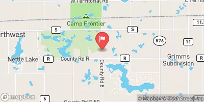
Lake Seneca Dam, located in Williams County, Ohio, is a private earth dam completed in 1966 for recreational purposes.
°F
°F
mph
Wind
%
Humidity
Summary
Standing at 36 feet high and stretching 990 feet in length, the dam provides a storage capacity of 8,117 acre-feet and covers a surface area of 233 acres. It is situated on the West Branch St. Joseph River and is regulated by the Ohio Department of Natural Resources.
With a high hazard potential and a fair condition assessment as of June 2018, the dam is subject to regular inspections every five years to ensure its structural integrity and safety. The dam's emergency action plan status and risk assessment measures are currently unspecified. Despite its age, Lake Seneca Dam continues to serve as a vital recreational resource in the area, attracting water resource and climate enthusiasts looking to enjoy the reservoir's scenic beauty and outdoor activities.
Managed by private ownership, Lake Seneca Dam stands as a testament to engineering excellence, designed by Ralph L. Woolpert Consulting Engineers of Dayton, Ohio. Its location in Montpelier, Ohio, offers visitors a tranquil escape into nature, surrounded by the picturesque landscape created by the reservoir's waters. As climate change and water resource management become increasingly important topics, Lake Seneca Dam remains a significant landmark for those interested in sustainable water infrastructure and its impact on local communities.
Year Completed |
1966 |
Dam Length |
990 |
Dam Height |
36 |
River Or Stream |
WEST BRANCH ST. JOSEPH RIVER |
Primary Dam Type |
Earth |
Surface Area |
233 |
Drainage Area |
106.8 |
Nid Storage |
8117 |
Hazard Potential |
High |
Nid Height |
36 |
Seasonal Comparison
Weather Forecast
Nearby Streamflow Levels

Dam Data Reference
Condition Assessment
SatisfactoryNo existing or potential dam safety deficiencies are recognized. Acceptable performance is expected under all loading conditions (static, hydrologic, seismic) in accordance with the minimum applicable state or federal regulatory criteria or tolerable risk guidelines.
Fair
No existing dam safety deficiencies are recognized for normal operating conditions. Rare or extreme hydrologic and/or seismic events may result in a dam safety deficiency. Risk may be in the range to take further action. Note: Rare or extreme event is defined by the regulatory agency based on their minimum
Poor A dam safety deficiency is recognized for normal operating conditions which may realistically occur. Remedial action is necessary. POOR may also be used when uncertainties exist as to critical analysis parameters which identify a potential dam safety deficiency. Investigations and studies are necessary.
Unsatisfactory
A dam safety deficiency is recognized that requires immediate or emergency remedial action for problem resolution.
Not Rated
The dam has not been inspected, is not under state or federal jurisdiction, or has been inspected but, for whatever reason, has not been rated.
Not Available
Dams for which the condition assessment is restricted to approved government users.
Hazard Potential Classification
HighDams assigned the high hazard potential classification are those where failure or mis-operation will probably cause loss of human life.
Significant
Dams assigned the significant hazard potential classification are those dams where failure or mis-operation results in no probable loss of human life but can cause economic loss, environment damage, disruption of lifeline facilities, or impact other concerns. Significant hazard potential classification dams are often located in predominantly rural or agricultural areas but could be in areas with population and significant infrastructure.
Low
Dams assigned the low hazard potential classification are those where failure or mis-operation results in no probable loss of human life and low economic and/or environmental losses. Losses are principally limited to the owner's property.
Undetermined
Dams for which a downstream hazard potential has not been designated or is not provided.
Not Available
Dams for which the downstream hazard potential is restricted to approved government users.
 Coulter
 Navarre
 Appleseed
 Houston
 Butler
 Clark
Clark
 Lake Seneca Dam