
Petermann Dam Reservoir Report
Nearby: Weber Dam 4056 Tull-Albers Dam
Last Updated: December 6, 2025
Petermann Dam, located in Gosper County, Nebraska, is a privately-owned structure designed for flood risk reduction along the TR-DRY CREEK.
°F
°F
mph
Wind
%
Humidity
Summary
Completed in 1970, this earth dam stands at a height of 17.7 feet and spans 290 feet in length, with a storage capacity of 63 acre-feet. Despite its low hazard potential, the dam's condition assessment is rated as poor, indicating a need for maintenance and repairs to ensure its long-term functionality and safety.
Operated by the Nebraska Department of Natural Resources, Petermann Dam is subject to state regulations, inspections, and enforcement measures to ensure compliance with safety standards. While the dam's primary purpose is flood risk reduction, its normal storage capacity of 21.3 acre-feet serves to mitigate potential inundation events in the area. Despite being classified as a low hazard structure, ongoing assessments and emergency action plans are essential to manage any risks associated with the dam and to protect the surrounding community in Edison.
As a critical infrastructure component in the region, Petermann Dam plays a vital role in managing water resources and climate-related challenges in Gosper County. With its location in a high-risk flood zone, continued monitoring, maintenance, and potential upgrades are necessary to safeguard the dam's integrity and functionality for the long term. Water resource and climate enthusiasts can appreciate the importance of this structure in maintaining the balance between flood control and environmental conservation in the area.
Year Completed |
1970 |
Dam Length |
290 |
Dam Height |
17.7 |
River Or Stream |
TR-DRY CREEK |
Primary Dam Type |
Earth |
Surface Area |
6.7 |
Hydraulic Height |
17.7 |
Drainage Area |
2.11 |
Nid Storage |
63 |
Structural Height |
17.7 |
Hazard Potential |
Low |
Foundations |
Soil |
Nid Height |
18 |
Seasonal Comparison
Weather Forecast
Nearby Streamflow Levels
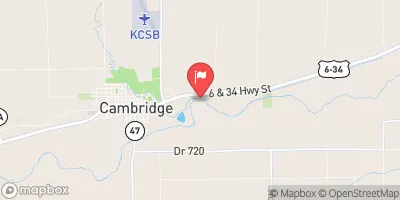 Republican River At Cambridge
|
60cfs |
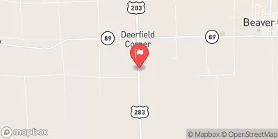 Beaver Creek Near Beaver City
|
1cfs |
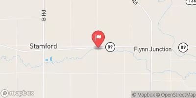 Sappa Creek Near Stamford
|
4cfs |
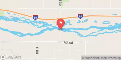 Platte River Near Overton
|
1040cfs |
 Spring Creek Nr Overton
|
7cfs |
 Republican River Near Orleans
|
59cfs |
Dam Data Reference
Condition Assessment
SatisfactoryNo existing or potential dam safety deficiencies are recognized. Acceptable performance is expected under all loading conditions (static, hydrologic, seismic) in accordance with the minimum applicable state or federal regulatory criteria or tolerable risk guidelines.
Fair
No existing dam safety deficiencies are recognized for normal operating conditions. Rare or extreme hydrologic and/or seismic events may result in a dam safety deficiency. Risk may be in the range to take further action. Note: Rare or extreme event is defined by the regulatory agency based on their minimum
Poor A dam safety deficiency is recognized for normal operating conditions which may realistically occur. Remedial action is necessary. POOR may also be used when uncertainties exist as to critical analysis parameters which identify a potential dam safety deficiency. Investigations and studies are necessary.
Unsatisfactory
A dam safety deficiency is recognized that requires immediate or emergency remedial action for problem resolution.
Not Rated
The dam has not been inspected, is not under state or federal jurisdiction, or has been inspected but, for whatever reason, has not been rated.
Not Available
Dams for which the condition assessment is restricted to approved government users.
Hazard Potential Classification
HighDams assigned the high hazard potential classification are those where failure or mis-operation will probably cause loss of human life.
Significant
Dams assigned the significant hazard potential classification are those dams where failure or mis-operation results in no probable loss of human life but can cause economic loss, environment damage, disruption of lifeline facilities, or impact other concerns. Significant hazard potential classification dams are often located in predominantly rural or agricultural areas but could be in areas with population and significant infrastructure.
Low
Dams assigned the low hazard potential classification are those where failure or mis-operation results in no probable loss of human life and low economic and/or environmental losses. Losses are principally limited to the owner's property.
Undetermined
Dams for which a downstream hazard potential has not been designated or is not provided.
Not Available
Dams for which the downstream hazard potential is restricted to approved government users.
 Petermann Dam