
Cheek Lake Dam Reservoir Report
Nearby: Carnes Lake Dam Perry Lake Dam
Last Updated: March 3, 2026
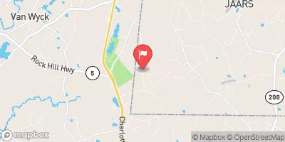
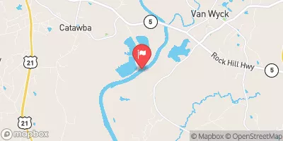
Cheek Lake Dam, located in Union, North Carolina, is a privately owned structure built in 1966 for fire protection, stock, and small fish pond purposes.
Summary
The earth dam stands at a hydraulic height of 15 feet and a structural height of 20 feet, with a length of 420 feet and a storage capacity of 54 acre-feet. The dam, situated on Stewart Branch, serves as a recreational spot covering a surface area of 4 acres, offering a serene environment for water resource and climate enthusiasts to explore.
With a low hazard potential and a condition assessment that is currently unrated, Cheek Lake Dam has not been regulated by the state authorities. Despite being inspected in October 2016, the dam does not require regular inspection as per the provided data. The emergency action plan status, risk assessment, and management measures for the dam remain unspecified, leaving room for further evaluation and preparedness in case of unforeseen events. As a focal point for fire protection and water conservation, Cheek Lake Dam presents an opportunity for environmental enthusiasts to appreciate and engage with the vital role of dams in sustaining local ecosystems.
As a part of the Charleston District in North Carolina, Cheek Lake Dam is a key feature in the Lancaster Sc area, contributing to the local landscape and water management system. While the dam's primary purpose is to serve as a reservoir for fire protection and recreational activities, its significance extends to supporting the ecosystem and providing a tranquil setting for visitors. The dam's history, design, and operational aspects make it an intriguing subject for those passionate about water resources and climate sustainability, urging further exploration and understanding of its role in the region's environmental landscape.
°F
°F
mph
Wind
%
Humidity
15-Day Weather Outlook
Year Completed |
1966 |
Dam Length |
420 |
River Or Stream |
Stewart Branch |
Primary Dam Type |
Earth |
Surface Area |
4 |
Hydraulic Height |
15 |
Nid Storage |
54 |
Structural Height |
20 |
Hazard Potential |
Low |
Nid Height |
20 |
Seasonal Comparison
5-Day Hourly Forecast Detail
Nearby Streamflow Levels


Dam Data Reference
Condition Assessment
SatisfactoryNo existing or potential dam safety deficiencies are recognized. Acceptable performance is expected under all loading conditions (static, hydrologic, seismic) in accordance with the minimum applicable state or federal regulatory criteria or tolerable risk guidelines.
Fair
No existing dam safety deficiencies are recognized for normal operating conditions. Rare or extreme hydrologic and/or seismic events may result in a dam safety deficiency. Risk may be in the range to take further action. Note: Rare or extreme event is defined by the regulatory agency based on their minimum
Poor A dam safety deficiency is recognized for normal operating conditions which may realistically occur. Remedial action is necessary. POOR may also be used when uncertainties exist as to critical analysis parameters which identify a potential dam safety deficiency. Investigations and studies are necessary.
Unsatisfactory
A dam safety deficiency is recognized that requires immediate or emergency remedial action for problem resolution.
Not Rated
The dam has not been inspected, is not under state or federal jurisdiction, or has been inspected but, for whatever reason, has not been rated.
Not Available
Dams for which the condition assessment is restricted to approved government users.
Hazard Potential Classification
HighDams assigned the high hazard potential classification are those where failure or mis-operation will probably cause loss of human life.
Significant
Dams assigned the significant hazard potential classification are those dams where failure or mis-operation results in no probable loss of human life but can cause economic loss, environment damage, disruption of lifeline facilities, or impact other concerns. Significant hazard potential classification dams are often located in predominantly rural or agricultural areas but could be in areas with population and significant infrastructure.
Low
Dams assigned the low hazard potential classification are those where failure or mis-operation results in no probable loss of human life and low economic and/or environmental losses. Losses are principally limited to the owner's property.
Undetermined
Dams for which a downstream hazard potential has not been designated or is not provided.
Not Available
Dams for which the downstream hazard potential is restricted to approved government users.
 Cheek Lake Dam